Tag Archives: smart growth

Silicon Valley Knows Technology, Not Land Use

Apple headquarters, Cupertino, Calif.

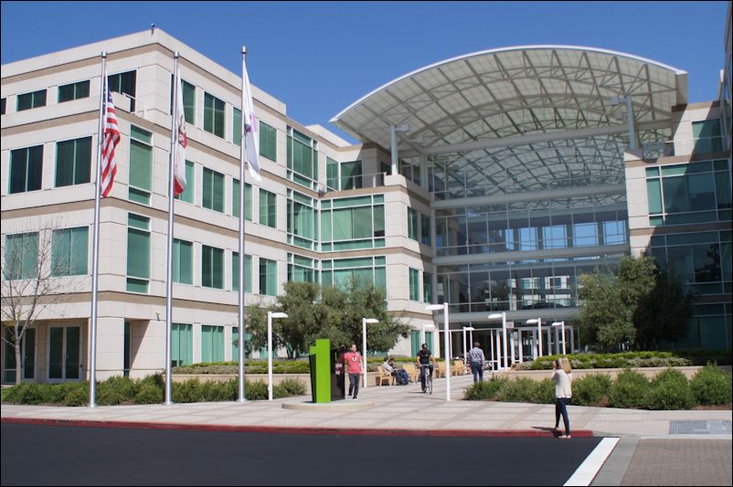
Apple headquarters, Cupertino, Calif. Impressive facade but poor public spaces.

by James A. Bacon

Apple, Google and other collosi of Silicon Valley are re-shaping the world with their technology but you could never imagine them as masters of innovation by viewing their corporate campuses. While the office interiors may be arrayed with java bars and collaborative workplaces to stimulate creativity, the building exteriors are for the most part bland steel-and-glass boxes of a type that can be found anywhere in the United States. Moreover, surrounded by parking lots and landscaping, the buildings are isolated — islands in a sea of mulch and asphalt. Creativity and interaction end at the front door. The streets, sidewalks and other pieces of the public realm are innovation dead zones.

That was the impression I gained from the Bacon family’s whirlwind tour of Silicon Valley earlier this week that took in the corporate headquarters not only of Apple and Google but Hewlett-Packard, Yahoo! and LinkedIn. Perhaps we arrived at the wrong time of year, the wrong time of the week or the wrong hour of the day but we saw almost nothing going on. Most of the street-level activity at Apple was generated by tourist traffic to the Apple store. The environs of the famed Googleplex were even more desolate.

google_bikes

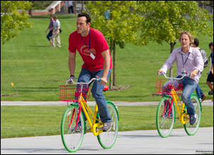
Vaughn and Wilson in “The Internship.”

I was expecting bustling outdoor scenes like those shown in the movie, “The Internship,” in which Owen Wilson and Vince Vaughn finagled their way into summer jobs at Google and into movie goers’ hearts. We didn’t see bupkis. I sneaked around the back of one of the buildings in the Googleplex and did discover an inviting patio with bright umbrellas but didn’t see anyone except a couple of maintenance guys standing around and shooting the breeze. As we drove around the Google corporate campus with its dozens of buildings, we did espy one multi-colored Google bike leaning against a wall and we did spot one fellow riding down the road, but we saw hardly anyone walking outside. Undoubtedly, billions of neurons were burning brightly inside Google’s buildings — but there was no sign of the company’s massive brainpower on display outside. It turns out that, according to CNN, much of the movie wasn’t filmed at Google at all — but the Georgia Institute of Technology campus in Atlanta!

The Google H.Q. is so low-key in appearance, we wondered if we had the right place. According to the Google corporate address listed in Google maps, we did.

The Google H.Q. is so low-key in appearance, we wondered if we had the right place. This is where Google Maps led us.

Who cares whether the innovation occurs inside or outside? Why mess with a proven formula? More to the point, what does a techno-tard like me have useful to say to the likes of Apple and Google, two of the greatest wealth creation machines in human history?

I didn’t visit Silicon Valley with the idea of lecturing the region’s political, business and civic leaders how to improve, which would be incredibly presumptuous on my part. I visited to learn what lessons other communities might learn. Scores of regions around the United States yearn to re-create some of the valley’s technology magic, and I worry they could draw the wrong conclusions. The one dimension of Silicon Valley that others can most readily replicate is its “suburban sprawl” pattern of development — and that would be the worst possible lesson to take away.

Apple parking lot

The parking lots outside Apple’s headquarters are beautifully landscaped but they wall off pedestrian access to the world outside.

I would humbly suggest that Silicon Valley has been insanely successful in spite of its dysfunctional human settlement patterns. Combine world-class research universities, the largest venture capital community in the world and an unparalleled workforce, then shake and stir. You’ll get technological innovation. Silicon Valley’s corporations can create a built environment that discourages interaction outside the firm and it doesn’t matter — the advantages of a Silicon Valley location far outweigh the drawbacks. But no one else has Silicon Valley’s potent mix of research universities, venture capitalists and the smartest engineers drawn from around the world. Other communities need every competitive advantage they can muster — and smarter land use patterns is one of them.

As Hans Johannson has argued in his book, “The Medici Effect,” innovation comes at the intersection — the intersection of different industries, disciplines, cultures or ways of thinking — that allow people to make unlikely combinations of ideas. Some places lend themselves to that kind of interaction, others don’t. Based on her experience living in Greenwich Village a generation ago, renowned urbanist Jane Jacobs brilliantly argued that sidewalks, small parks and mixed uses lent themselves to the kind of meetings and encounters, often serendipitous, where different perspectives and ideas can collide. To spawn entrepreneurship from the ground up, those are the kinds of neighborhoods and communities that aspiring tech centers should be creating.

The built environment of Silicon Valley is Northern Virginia with palm trees — predominantly single-family houses, strip malls and office parks. Thanks to municipal codes and NIMBYs, the region can increase density only sparingly, so it cannot grow “up” by building taller buildings. But wedged between the bay to the north and mountains to the south, it cannot grow “out” through additional sprawl. As a consequence, real estate prices are incredibly high. The cost of housing across the Valley and throughout the entire Bay area is consistently cited as one of the greatest hindrances to living there. The number of homeless in the San Jose metro region, according to the Wall Street Journal, numbers roughly 7,600. To adopt similar land use policies would suicidal for any other region.

Municipal leaders recognize these shortcomings and are attempting belatedly and with mixed results to deal with them. I will discuss two such initiatives in Sunnyvale, as time permits.

In Praise of Small Spaces

SONY DSC

Stairway across from the Ritz Carlton on Nob Hill.

by James A. Bacon

I am fascinated by small urban spaces that normally elude the attention of city planners,  star architects and travel magazines. In low-density settings where low value is placed on land, inhabitants pay little heed to the small spaces. But in densely settled cities, residents apply loving creativity to making the most of the nooks, the crannies, the alleyways and the odd bits of land around them. The accumulation of detail in these small spaces is part of what makes a city like San Francisco great.

Some of the most interesting sights I saw here were tucked away in alleyways and in-between spaces. Many of them were stairways.  The photo above shows a particularly beautiful stairway that led between two houses to a destination up the hill. (I was too tired trudging up and down hills to see where it led.)  With manicured trees and flowers along the edge, this stairway was a significant enhancement to the neighborhood.

The stairway below is all the more interesting because it is all the more ordinary, part of an alleyway on a steep hillside that provides access to several nondescript apartment dwellings. It shows few signs of anyone having lavished money upon expensive materials or landscaping upon it, yet it is visually interesting nonetheless.

SONY DSC
Continue reading

Why San Franciscans Are Thinner than Other Americans

SONY DSCNo, it’s not the bean sprouts and tofu. It’s not even the great year-round climate that encourages people to do stuff outdoors. It’s the hills. The Bacon family has hiked and biked a lot of hills over the past three days and we’ve eaten a lot of food, but the hills won. I swear I have cinched in my belt buckle by a notch.

As I recall, one of the largest concentrations of superannuated (really old) people is in the Caucasus Mountains. The Georgians, Armenians and Azerbaijanis get lots of exercise walking up and down mountains. Living around hills is healthy! I don’t recall seeing a single fat person in San Francisco. (OK, maybe a couple of hefty people but no obese people). I’ve seen more little old Chinese ladies on walkers chugging up the hills in Chinatown than I’ve seen fat people.

Oh, maybe I should add that it’s not just the hills. It’s the hills in combination with the sidewalks. San Francisco is a walking town. The city has great streetscapes and no matter where you are there is an abundance of destinations within walking distance. People walk places, and when they walk, they walk on hills. It’s that simple.

— JAB

Bicycling in Paradise

SONY DSC

One of California’s greatest assets is its climate, and San Francisco, though foggier than nearby locales, is no exception. Climatically speaking, the city is as close to paradise as any location on the planet, which makes it a great place to spend outdoors and a great place to bicycle. As one would expect, San Francisco has an advanced bicycle infrastructure, with some dedicated bike lanes and lots of sharrows. Also bicycling is embedded deeply enough in the transportation system that you don’t feel like you’re taking your life into your hands when you share the roads with cars.

Quite possibly the bike lane with the most awesome views in the world.

Quite possibly the bike lane with the most awesome views in the world.

Having spent only a couple of days here, I cannot profess any expertise on the biking scene, but it seems pretty clear that with all the mass transit — between buses, light rail, trolley cars and cable cars, San Francisco may have more different types of mass transit than any other city in the world — not to mention ZipCar and Uber, anyone can get around perfectly well owning a bicycle instead of a car. The main drawback to establishing a strong bicycling culture here is the hills — they’re not for the weak.

One of the things I like about San Francisco is that, although it is very dense (the second densest city after New York City, as I recall), it is as not automobile-hostile as Manhattan. Owning your own car is not an act of folly, as it would be for most Gothamites. Thus, the city offers the widest possible array of transportation choices. (The way the city handles parking is particularly interesting. I’ll have more to say about that in a later post.)

Clearly, the end product is something that people value highly. Between the superior economic opportunities afforded by the technology- and innovation-economy in the San Francisco Bay region, the divine climate and the quality of human settlement patterns, people have bid up the price of real estate to astronomical levels.

— JAB

The City of Great Places

Belden Street

Belden Street

So, here we are in San Francisco, in the heart of the land of fruits and nuts. We’re  planning to do a lot of the usual tourista things — take the boat to Alcatraz, bike to Sausalito, visit the Exploratorium — but your roving correspondent also will be applying a keen eye to the human settlements patterns of one of the United States’ most remarkable urban experiments.

San Francisco and nearby Silicon Valley comprise the most economically productive region in the U.S. (with the possible exception of Manhattan, although I regard the New York financial industry as a monstrous parasite that, due to Quantitative Easing, prospers at the expense of the rest of the country). San Francisco and San Jose (and environs in between) also happen to have the most expensive real estate prices (outside, perhaps, Manhattan) and the greatest income inequality in the country. Yet there is a remarkable divergence between Frisco and Silicon Valley. San Francisco hews to the Smart Growth ideals of higher density, mixed-use, walkable and transit-oriented human settlement patterns while Silicon Valley epitomizes sprawl. San Francisco is a tourist destination; Silicon Valley is not. I don’t know what all that adds up to but it is my framework for writing whatever I write about.

First observations: Arriving Saturday evening fatigued from a long trip, the Bacon farrow (farrow? Look it up.) checked into its hotel and set out to grab a meal before hitting the sack. There is a delightful little street near our hotel — Belden Street on the edge of Chinatown (see photo above). It really isn’t even a street, it’s more of an alleyway, too narrow for cars, that is lined with seven or eight restaurants. There is nothing exceptional about the street; it’s just one small example of the place-making that inspires love of this city. The alleyway is a visual surprise in that is represents a departure from the dominant street grid. Cozy and intimate in its human scale, it is a delight to stroll through.

Multiply Belden Street hundreds of times across the region and you get a place where people love to live and are fiercely loyal to.

— JAB 

Can Virginia Reverse the Stroadification of Rt. 1?

The Rt. 1 area under study. Click for larger image.

The Rt. 1 area under study. Click for larger image.

by James A. Bacon

People living along the U.S. Route 1 corridor in Northern Virginia seemingly desire contradictory things. They want better pedestrian and bicycle safety, they want mass transit. … and they want automobile traffic to flow faster. Alas, designing the corridor to move automobiles faster makes roads less safe, and it discourages the kind of development that would invite the higher-density, mixed-use development that would support mass transit.

Stewart Schwartz, executive director of the Coalition for Smarter Growth, explores the dilemma in a thoughtful two-part series (Part 1 and Part 2on the challenge of re-developing Route 1. His solution, at the risk of over-simplifying, is to switch the perspective from designing the corridor for cars to designing it for people. Planners are scheduled to submit specific recommendations for the corridor by July. If they focus on creating walkable, transit-oriented communities, Schwartz contends and I concur, automobile traffic flow will improve as well.

A few years back, the Virginia Department of Transportation proposed reducing posted speeds from 45 m.p.h. but an uproar ensued. Apparently, too many people depended upon U.S. 1 as a commuter route and imagined that lower posted speeds would translate into lower actual speeds and longer commuter time. But lowering the speed is critical to achieving the goal of walkability, walkability is required to make mass transit economically viable, and viable mass transit is required to reduce the volume of cars on the highway.

The problem is that U.S. 1 fits the classic definition of a stroad, a street-road hybrid. The route started as one of America’s first national highways. But Virginia state and local governments neglected to control access to the highway, with the result that it became cluttered with haphazard development, cut-throughs, curb-cuts and stoplights. Functionally, in Northern Virginia, Fredericksburg, Ashland, Richmond and Petersburg, the highway became a main street. Yet it failed to fulfill the functions of either highway or main street properly. The lanes were too wide and the speeds too intermittently high to create walkability or the higher-end development that is drawn to walkable places. At the same time, Rt. 1 became so congested with local traffic that it failed as a highway.

At some point, the people of Alexandria and Fairfax County must decide whether they want Rt. 1 fulfill its destiny as a highway or a street. It cannot do both.

Rt. 1 should be easier to salvage in Northern Virginia than in points south. There is so much demand in the region for walkable, transit-oriented communities that private investors should be able to re-develop the low-value development that exists now at higher densities fairly quickly. Proffers and/or impact fees, sweetened by higher density allowances, should be available to pay for streetscape improvements to make the corridor more hospitable to pedestrians. Further, there is such a large volume of traffic that the corridor should be able to support mass transit.

Transportation planners could help by reallocating right of way, in effect converting the former in-name-only highway from a stroad to a street. Reducing lane widths from 12 to 10 feet would free space for bicycle lanes and make the “highway” easier for pedestrians to cross. Yes, narrower lanes would slow the peak travel speed of thousands of commuters to Fort Belvoir. But if the narrower lanes were accompanied by less automobile traffic, lower posted speeds could be offset by shorter waits at traffic lights, less stop-and-go.

All urban Virginians should follow the Rt. 1 experiment with great interest. If Northern Virginia can find a workable solution for the old Jefferson Davis Highway, there is hope for the rest of us.

More Virginia Families Choosing Cities, City Schools

by James A. Bacon

It has been the traditional pattern in Virginia, as elsewhere, for young people to move to core urban areas to live as singles and then migrate to the quieter, safer burbs with better schools when they marry and have children. That dynamic still is working but it is weaker than before. More young families are staying put in urban jurisdictions to raise their kids and enroll them in local schools, feeding the strongest population growth that many Virginia cities have experienced since the 1950s.

And that, notes Hamilton Lombard on the StatChat blog, is forcing many cities and counties to re-work their school enrollment projections and their capital spending plans.

Lombard displays the data in a way I have never seen presented before. The chart below (modified slightly for purposes of clarity) compares the number of births in a jurisdiction to the number of children who went on six years later to enter the school system in 2005. Jurisdictions to the left of the line, mostly urban city jurisdictions, saw a marked loss of school-age children. Localities to the right of the line, mostly suburban counties, had far more children enroll in their schools than were born there previously. The chart show the dominant post-World War II pattern of young families moving from the city to the burbs.

importers_exporters
That was 2005. Now look at 2013 below. What’s different? Well, around 2006, per capita Vehicle Miles Driven peaked — people began driving less. Smart Growth advocates suggest that the younger generation is less infatuated with cars and prefers to live in walkable communities with access to mass transit. Then in 2007-2008 came the real estate crash and the Great Recession. As Lombard observes, mortgage rules tightened and it is harder now for families to buy a house in the ‘burbs. People are staying put. Only one-third as many homes were sold in Virginia in 2012 as in 2005. The number of Virginia families with children living in rented residences has increased 15%.

The shift in school enrollments is marked: Urban core jurisdictions are exporting fewer families with children, and counties are importing fewer.

2013_jumbled

Lombard sums up the impact on school systems:

Elementary schools have been among the first to feel the impact of the change in growth trends. Most rural and suburban elementary schools have too much classroom space because fewer families have moved to their divisions. At the same time, many urban school divisions, after decades of shuttering schools, are reassessing their capital improvement plans so they have enough space for the increases in enrollment.

Bacon’s bottom line: There are several points to be made.

First, this data refutes the commonly held notion that most young families with the means to do so all will desert core cities and move to the suburbs when their children reach school age. Clearly, some young families are still making the move but more are staying. Whether this trend represents a fundamental shift in lifestyle preferences, a temporary effect of economic hard times or a little of both is hard to say. But the fact is undeniable: An increasing number of young city dwellers is growing, which is driving population growth in urban cores.

Second, it is good to see that analysts at the Weldon Cooper Center’s demographics research group, which publishes StatChat, are beginning to document this seismic demographic shift. If these insights get incorporated into the state’s official population projections, it will impact how dollars are spent in many areas, not the least of which is transportation. Kudos to Lombard for work well done.

Third, once middle- and professional-class families begin enrolling their children in urban-core jurisdictions in larger numbers, it could have a profound effect on how those schools are perceived. If the perception of inner city schools improves from dismal to not-so-bad, even more families might be willing to forego the suburban relocation. It’s way too early to say that that city schools have reached a tipping point but it’s not beyond the bounds of possibility.

Tech Insurrection

AnthonyTownsendSmart cities, says Anthony Townsend, will be forged by geeks, activists and civic hackers through bottom-up technological innovation.

By James A. Bacon

Anthony M. Townsend, a research scientist at New York University, has made a big splash with his book, “Smart Cities: Big Data, Civic Hackers, and the Quest for a New Utopia,” in which he makes the case for a bottom-up, technology-driven transformation of the world’s cities.  But he’s not satisfied with preaching from his academic perch on how a grassroots movement of civic hackers is rewriting the social contract between citizens and government. He is taking active part.

As audacious as it may sound, Townsend hopes to build a peoples’ wireless telecommunications system on the New Jersey coast in place of the ATT and Verizon networks that failed during Hurricane Sandy. He is one of a group of citizen volunteers in the Hoboken area who are patching together a distributed wireless network at very little cost. Paralleling the municipal Wi-Fi movement of a decade ago, each participant contributes a piece of the network. The trick is to tie all the pieces together.

“For $60 we can configure a radio that someone can take to their house and point to our rooftop tower,” he explains. The devices discover one another and, in the fashion of a bucket brigade, pass packets of information from one to another. “We’re putting a network together with our bare hands and spare change.”

The reward will be reliable, almost no-cost Internet service that should have enough redundancy built in to withstand another hurricane. Elevating the network to a level of performance on a par with the incumbent providers will be a challenge, Townsend admits.  There will be gaps in their system. But the plug-and-play, distributed nature of their system will cost a tiny fraction of what the telecoms spend on cell towers, infrastructure and other overhead. “It’s very cheap and easy to build,” he says. “We’ll be a lab to test it in the real world.”

Imagine the same kind of technological disruption applied to the electric grid, mass transit, paid transport services, parking, municipal lighting, water and sewer, education and other municipal systems. Then imagine technology applications that no one in municipal government or the Fortune 500 companies are even thinking about – like citizens collaborating to monitor the environment. Municipal government could become unrecognizable. Indeed, it’s no exaggeration to say that, if Townsend’s vision pans out, institutions for providing utilities and local government services will be reinvented on a scale not seen since the early 1900s.

The agents of disruption likely will not be municipal governments themselves, nor even the big technology companies and management consulting firms peddling efficiency and productivity solutions to local governments, says Townsend. The innovators will be tech-savvy citizens – civic hackers – who exploit the rapidly declining cost of sensors, microchips, wireless connectivity and networking technologies to conduct lots of experiments, learn rapidly and disseminate best practices around the globe. Already, he says, “The really transformative things are built by hackers, artists and entrepreneurs that are very end-user focused.”

Needless to say, there is some very smart money – with very deep pockets – that says Townsend is wrong. Tech giants like Cisco and IBM see local government, utilities and infrastructure as an emerging multitrillion-dollar market. At the 2014 Consumer Electronics Show, Cisco CEO John Chambers forecast cumulative revenue and productivity gains for the government sector globally to reach $4.6 trillion by 2020. Big Tech promises the ability to monitor things that have never been monitored, collect unprecedented volumes of data and crunch the numbers to identify patterns and anomalies that municipal managers had not noticed. By reducing leakage from water pipes, improving police response times, coordinating traffic signals and reducing power usage by street lights, technology companies promise billions of dollars in savings. Equally ambitious, IBM markets a “decision support system” that accesses vaults of under-utilized municipal data to analyze the interaction between everything from building permits to high school drop-out rates, housing vacancies to commuting times, to help managers and elected officials understand how investing money in one government sector will reverberate through the system to impact other sectors.

In a recent online debate with Townsend organized by the Economist magazine, Irving Wladawsky-Berger, a VP emeritus with IBM, argued against the proposition that “smart cities are empty hype,” insisting that top-down governance could work. “Digital technologies and the many data services they are enabling will significantly transform cities and make them smarter,” wrote the IBM executive. “These are highly complex projects, requiring considerable research and experimentation. As is generally the case with disruptive technologies, it is all likely to take longer than we anticipate, but the eventual impact will probably be deeper and more transformative than we imagine.” Not surprisingly, Wladesky-Berger sees the big corporations playing a major role.

Taking the position that smart cities are hype, Townsend raised the specter of tech companies creating proprietary “urban operating systems” and ecosystems of software vendors that extract royalties for “shuttling our money and data around smart cities.”  Worse, he said, “once ensconced, these firms will be nearly impossible to dislodge.” Read more.

(Cross posted from the Datamorphosis blog.)

Columbia Pike Streetcars: Delving Deeper into the Value-Capture Scenario

by James A. Bacon

Last week, I made the case that the best way to finance construction of the proposed Columbia Pike street car line in Arlington was to set up an improvement district along the route and impose a real estate tax surcharge on property owners to pay off the bonds. (See “A Second Opinion on the Columbia Pike Streetcar.“) “If the property owners are willing to go along, it’s probably a good idea. If they balk, it’s probably not.”

In response, I received an email from Eric Balliet, a communications specialist with Arlington County. His email is worth reproducing in full:

Your concern that the County is not asking the primary beneficiaries of streetcar – property owners along the streetcar line – to pay for these improvements is not completely accurate. Local funding for the streetcar will come from the Transportation Capital Fund, which is used for major investments in transportation infrastructure throughout the County. The Fund is supported by a commercial real estate tax rate of $0.125 per $100 of assessed value. This tax rate applies to all commercial and industrial properties – including those along the streetcar line. Before the General Assembly provided this funding mechanism for jurisdictions to improve transportation infrastructure, the County used limited general tax revenue for that purpose, including for development of Metrorail in the Rosslyn-Ballston and Route 1 corridors.

The County also has established tax increment financing (TIF) to capture the property value created by redevelopment to fund streetcar and other priorities. The Crystal City-Pentagon City-Potomac Yard TIF is helping to pay for infrastructure improvements such as streetcar in support of the Crystal City Sector Plan. The new Columbia Pike TIF will dedicate up to 25 percent of tax revenue growth generated by new development and property appreciation in the commercial and multi-family residential revitalization districts to affordable housing along the Pike. This ensures that some of the money generated by streetcar will help meet our goal of preserving existing affordable housing along the Pike as property values and rents increase.

One final note – regarding the capacity of streetcar versus bus: Today on Columbia Pike, nearly 600 bus trips per weekday carry more than 16,000 passengers daily. Buses already come every 2-3 minutes in rush hour. Based on updated regional population projections and County-adopted plans, we need transit capacity of 38,000+ daily on Columbia Pike by 2035 to ensure it doesn’t become gridlocked. There is not enough street capacity for buses alone to accommodate that many passengers. A streetcar vehicle can hold 100% more passengers than a regular bus and 40% more than an articulated bus. Accommodating more people in fewer vehicles is key to keeping traffic moving.

I thank Balliet for educating me about the mechanisms being used to finance the street car line, of which I had been unaware. This information enrichens the debate. I must give the Arlington Board credit for recognizing that commercial interests would be major beneficiaries of the county’s roughly $300 million streetcar investment and for creating mechanisms that would capture some of the value created by that investment to lessen the burden on general taxpayers. That alone puts Arlington’s streetcar proposal way ahead of downstate mass transit projects, such as Bus Rapid Transit in downtown Richmond and a light rail extension in Virginia Beach, which have no value-capture elements of any kind. So, I toff my hat to the Arlington Board.

That said, while preferable to funding the entire county share from General Fund revenues, Arlington’s financing mechanism is still deficient. First, by imposing what amounts to a real estate tax surcharge on all commercial and industrial properties, the board is creating what might uncharitably be termed a slush fund for transportation projects which, by their very nature, benefit some commercial interests but not others. While the mechanism is fair to residential taxpayers, it is not necessarily fair to commercial property owners. Second, using tax increment financing (TIF) to tap 25% of the growth in property tax revenue generated by new development is largely a cosmetic measure. Columbia Pike property owners enjoy the blessings of higher leases and rents but don’t pay any more under this scheme.

To my mind, there are two important benefits to a strict value-capture financing scheme. One is that it is fairer, requiring beneficiaries of the public improvement pay for the improvement. Second, it creates an objective and non-political mechanism for weighing the risk-adjusted rate of return on the improvement. Let’s imagine that we set up a special Columbia Pike Streetcar District and tell property owners in that district (picking numbers for purposes of illustration), “We’re going to add a 25% surcharge to cover the full cost of financing construction of the streetcar and pay for operating costs not covered by fares. In return, you will get a streetcar system which, by our calculations, will bolster your rents and leases by 10% over time. There are uncertainties in all these numbers but we think we’re pretty close. Would you vote for or against this idea?”

If presented with this choice, the property owners would engage in a vigorous debate over the merits of streetcars and the assumptions embedded in the proposal, leavened by their own intimate knowledge of business conditions and property values along the route. Unlike planners, politicians and pontificators, they would have skin in the game. They would have the most to gain if the streetcar is a hit and the most to lose if it’s a bust. They, unlike politicians, would be likely to base their preference not on ideology but upon a keen awareness of the bottom line. They would be far less likely to engage in wishful thinking. If a significant majority of property owners agreed — as they did when they set up the special tax district to finance U.S. 28 improvements near Washington Dulles International Airport — then the public can have far more confidence that the project makes sound economic sense. That’s no guarantee, of course; businesses often bet wrong on investments. But they bet wrong a lot less frequently than do politicians playing with others peoples’ money.

One last note: Regarding for the carrying capacity of buses versus street cars, there is a lively discussion on an email thread initiated by Rob Whitfield. Has anyone considered the economics of running double-decker buses along Columbia Pike?

What Happened? Did All the Racists Move North?

Image credit: New York Times

Image credit: New York Times

by James A. Bacon

NewYork state has the most segregated schools in the country, according to a new report published by the Civil Rights Project at the University of California, New York State’s Extreme School Segregation.Other states with highly segregated schools include Illinois, Michigan and California.

“In the 30 years I have been researching schools, New York state has consistently been one of the most segregated states in the nation — no Southern state comes close to New York,” said Gary Orfield, co-director of the project, as quoted by the Associated Press.

Hmmm. How remarkable. What do those four states have in common? Here’s one thing. Their electorates all skew liberal and Democratic, as shown by the percentages that voted for Barack Obama in 2012:

New York — 62.6%
California — 59.3%
Illinois — 57.3%
Michigan — 54.3%

Bacon’s bottom line: Liberals have the loftiest of intentions. They pride themselves upon their enlightened racial attitudes and routinely malign their Republicans and conservative opponents as racist. But there is a vast gulf between intentions and results. It is no accident that the most segregated schools in the country are in blue states. Segregation is the unintended outcome of other “progressive” policies, particularly zoning, also enacted for the very best of reasons. (See Daniel Kay Hertz’ essay on the link between zoning and segregation in Chicago for how that works.)

The trouble with most liberals (not all, there are a few honest ones) is that they seem so incapable of self-reflection. Will this study prompt serious introspection and a wave of reform in New York? Will white liberals, struck by their massive hypocrisy, restrain their impulse to label as racist those who disagree with their policy prescriptions? Not a chance.

Most realistically, will African-Americans, traditionally a core constituency of the liberal/Democratic coalition, wake up and realize that their real enemies are not racists under every bed (like the phantasmagorical communists of the McCarthy era) but the ideology and practice of liberalism? I think that’s a distinct possibility.

Sprawl’s Hidden Subsidies

perverse_citiesby James A. Bacon

If planning and regulation were the answer to sprawl, then the Toronto metropolitan region ought to be a smart growth paradise. Toronto has a sophisticated, multi-tiered planning process, starting with an regional plan, plans for 30 upper-tier municipalities, and plans for 241 lower-tier municipalities (towns and townships, mostly). Yet outside the city of Toronto itself, which is undergoing a condo boom, there isn’t much to show for it.

The various municipal plans, which are comparable to Virginia’s comprehensive plans, define urban boundaries, control densities and show where growth should take place. The goal is for 40% of all new residential units to be built in already-urbanized areas. “That’s not happening,” says Pamela Blais, a city planner and principle of Toronto-based Metropole Consultants. “All the plans said all the right things. … [But] the regulatory approach isn’t sufficient to bring about the change.”

The failure of regulation to halt sprawling, auto-centric development was the basis for Blais’ 2010 book, “Perverse Cities: Hidden Subsidies, Wonky Policy and Urban Sprawl.” She had researched and written the volume to figure out how the planners’ plans had gone awry. If smart growth made so much sense, and if planners had the power to bring it about, why weren’t developers and home builders doing what they were supposed to do? Something else had to be going on, she reasoned, something that was not commonly recognized.

pamela_blais

Pamela Blais

As she delved into the subject, Blais found that real estate development is guided by massive hidden subsidies that shift costs from inefficient, land-intensive development to efficient, compact development. These invisible subsidies work at cross purposes to the regulations. As it turns out, developers follow the dollar.

Blais describes herself as a pragmatist. “It’s not an ideological argument I’m making,” she told Bacon’s Rebellion. “I’m interested in getting better cities. I’m happy to talk to everybody on the whole spectrum.” But her approach to urban development is one that fiscal and free-market conservatives can appreciate. The system for pricing public goods such as roads, water, sewer, electricity and public services bears little relationship to the cost of providing those services, she argues, with the result that a tangled skein of hidden subsidies incentivizes low-density development.

“Everybody thinks [sprawl] is the the invisible hand of the market. It’s a highly distorted market,” she says. “I’ve been arguing, let’s remove the distortions and take it from there. Remove the distortions and you’ll get a different development pattern. That should be the starting point.”

That is very much the argument that I have made in Bacon’s Rebellion, based largely on the work of EM Risse in his work, “The Shape of the Future” and essays published on this blog several years ago. Risse argued that charges do not reflect their “location-variable costs,” a succinct phrase that captures the spirit of Blais’ argument. In my reporting, I have focused mainly on one set of costs — transportation — but Blais carries the analysis to charges for utilities, municipal services, housing, parking and development charges as well. In “Perverse Cities,” she exhumed an impressive body of research to document her thesis across the board.

When you subsidize sprawl, you get more of it. When you penalize smart growth, you get less of it. To achieve smart growth objectives, Blais argues, what the United States and Canada need is not more regulation, which can create distortions of their own, but prices that reflect the underlying costs of development. 

Blais doesn’t oppose all subsidies. But she thinks they should be transparent and a subject of public discussion. “Right now, we’re not even having those discussions. People aren’t aware those cross subsidies are happening.” Here is a sampling from her book of how hidden biases are built into the system:

Water-sewer. Water-sewer charges typically are applied uniformly across a service area, regardless of how much it costs to provide the service. Sometimes charges vary by the volume of water; sometimes they do not. But charges rarely vary by the capital cost of extending water-sewer pipe longer distances to serve scattered, low-density housing, nor the operating cost of pumping water those greater distances. As a consequence, homeowners living in compact urban areas where the service is inexpensively supplied wind up subsidizing homeowners living in low-density areas where it is more expensive. Those subsidies could be avoided by breaking water charges into two components: a charge based on the volume of water consumed and a location-based charge that reflects the cost of building and maintaining the pipes. Continue reading

Measuring Sprawl

sprawl_index

by James A. Bacon

The Charlottesville region is the least afflicted by “sprawl” of any metropolitan statistical area in Virginia over 200,000 in population, according to data in a new report, “Measuring Sprawl 2014,” published by Smart Growth America and the Metropolitan Research Center at the University of Utah. Charlottesville’s composite score ranked it the 43rd least sprawling MSA among the 221 regions surveyed.

The Washington-Arlington region scored 91st in the ranking, followed by Hampton Roads, Roanoke, Richmond, Lynchburg and Bristol-Kingsport, in that order.

The researchers compiled the scores based on 28 variables falling into four main categories: density, land use mix, activity centering and street accessibility. Regions that were judged to be more compact and higher density, to have a better balance of jobs to population on a census-tract level, to have strong downtowns and other definable centers of activity, and to have superior walkability scored higher and were deemed to have the least sprawl.

While the Washington region has the 6th most compact, walkable urban center in the country, the region as a whole fared relatively poorly because the commuting shed that defines the MSA extends across many low-density counties as far away as West Virginia.

The authors said that a region’s position on the spectrum of sprawl between New York City, the nation’s most dense MSA, and Hickory-Lenoir, N.C., the most sprawl-prone large region in the county, is correlated with health, prosperity, quality of life and fiscal health. They hope the report will inspire local political and civic leaders to take a closer look at regional land use patterns.

A breakdown of Virginia counties provides insight into the wide variability within MSAs. In the Washington MSA, compare Arlington with a sprawl score of 163.28 to Stafford County with a composite score of 85.09. In the Richmond MSA, compare the City of Richmond with a score of 158.90 with Goochland County with a score 68.17.

The top composite scores in Virginia were:

City of Norfolk (179.57)
City of Charlottesville (175.93)
City of Alexandria (169.56)
Arlington County (163.28)
City of Richmond (158.90)
City of Harrisonburg (145.19)
City of Falls Church (144.69)
City of Winchester (142.10)
City of Williamsburg (138.61)
City of Fredericksburg (137.06)
City of Roanoke (136.69)

Complete scores are as follows: Continue reading

The Long, Sad, Inevitable Demise of Small Town America

population_loss

Map credit: Brookings Institution

by James A. Bacon

In theory the past decade should have been very good for America’s small towns and rural areas: The fracking revolution has created an energy boom in places as far flung as western Pennsylvania and North Dakota. High prices for agricultural commodities have propped up incomes across the grain belt. Yet, despite the strength of the natural resource economy, non-metropolitan populations are shrinking.

Summing up Bureau of Census data through 2013, the Brookings Institution concluded that, outside of energy boom towns and retirement magnets, the future does not look good for small town America. Communities outside of metropolitan statistical areas showed the third straight year of population loss in 2013. Small cities and towns dependent upon manufacturing have been particularly hard hit.

In this blog, I have frequently cited the work of urban geographers who explain that a knowledge-based economy favors large metropolitan regions with large labor markets of skilled and educated employees. Knowledge-intensive companies gravitate to regions where they can hire workers with the skills they need, and workers gravitate to regions where they can find employment. While this trend does not trump all other considerations — Detroit is a case in point — it is powerful. Only in unique circumstances — a university town, an energy boom town, a town blessed with extraordinary climate or beauty — can small towns fight the tide. Small towns dependent upon light manufacturing especially appear doomed to long-term decline.

In his recently published book, “The Economic Viability of Micropolitan America,” Gerald L. Gordon asks the question, can micropolitan areas (urban centers with populations between 10,000 and 50,000) survive? Gordon is best known in Virginia as CEO of the Fairfax County Economic Development Authority, one of the most respected and successful economic development enterprises in the country. But he also has an academic bent and when he’s not closing big deals like the relocation of Volkwagen USA and Intelsat to Fairfax County, he’s teaching economic development as an adjunct faculty member and doing his own research.

The latest book is one in a series aimed at extracting economic development lessons from communities large and small around the U.S. For this book, Gordon interviewed the mayors of 70 micropolitan communities, including two in Virginia: Danville and Martinsville. While small-town mayors maintain an up-beat outlook as their communities’ chief salesmen, the outlook Gordon describes is grim.

One rampant problem is the brain drain, the loss of residents with skills and education, to larger metropolitan areas that offer superior career prospects. The small towns’ problem is the inverse that of the major metros. Lacking a skilled and educated workforce makes it difficult to attract higher-quality employers; the lack of higher-quality employers makes it difficult to recruit or retain educated workers. Writes Gordon:

The loss of a primary employer means more than the loss of jobs and taxes. It can also mean the loss of the best of the workforce in the city as well as private support for organizations and causes throughout the community. This brain drain is an extremely serious for micropolitan cities.

That problem feeds another one: The erosion of the business tax base and the loss of higher-income individuals reduces the resources available to small towns and cities to make the investments in education and infrastructure they need to grow. “The ‘Catch-22’ is that the community then becomes less attractive to potential new residents and employers.

If there is a magic formula for success, Gordon didn’t find it. Indeed, his summary chapters are remarkably pessimistic — not for any apocalyptic language, which he studiously avoids, but for the simple paucity of plausible economic-development strategies beyond the well-worn ideas of diversifying the economy and revitalizing downtown.

That’s not to say that the future of micropolitan America is hopeless. There is a niche for people who prefer a slower-paced life in a tightly knit community where everyone knows and supports one another. For the most part, those people are retirees. I confess, I did not read all 70 of the community profiles, but I saw little discussion of what it takes to become a successful retirement community — something any region with access to beaches or mountains can reasonably aspire to. Continue reading

Map of the Day: Impact of Conservation Easements

2006 population distribution, Beltway to Winchester.

2006 population distribution, Beltway to Winchester.

Luke Juday is using his mapping tools over at the Weldon Cooper Center for Public Policy to project what Virginia’s population distribution could look like 25 years from now and 50 years from now. You can see those maps here. We’ve re-published many of his maps here at Bacon’s Rebellion, so you may find them familiar. But Juday is always tweaking, and always looking for more geographic databases to play with, and he has done something really new: He shows how conservation easements in Loudoun and Fauquier counties could shape Northern Virginia’s growth trajectory over the next half century.

Beltway to Winchester 50 years from now -- conservation easements in blue.

Beltway to Winchester 50 years from now — conservation easements in blue.

As Juday writes, “Conservation easements matter”… at least when they achieve critical mass, as they have done in the Middleburg-Upperville hunt country area. The easements could play a major role in blocking the western advance of the Washington metropolitan region, forcing development south toward Fredericksburg.

Please note that Juday does not describe these maps as a “forecast” or “projection.” Rather, they are a visualization of how population would be distributed if (a) Weldon Cooper’s planning district-level population projects prove accurate, (b) no “game-changer” roads are built such as the Prince William Bi-County Parkway and (c) regions develop at their current level of density. The visualizations ignore zoning, which is too complex to include in his mapping routine, and it does not reflect the very real possibility that Americans (and Virginians) are driving less, with the implication that trend would have for greater urban density and infill. Finally, I would add, the map doesn’t consider the likelihood that northern Piedmont landowners will continue to place land in conservation easements, meaning that the swaths of blue will get even thicker and more formidable.

Even with all those caveats, the visualization shows how, over a long period of time, conservation easements could become as important as rivers, bays and Interstate highways in shaping Northern Virginia’s future.

— JAB

How to Create Healthier Communities without Breaking a Sweat

healthy_placesby James A. Bacon

American society is buckling under the strain of health care costs. The debate, as I have often opined, is stuck on the question of who pays those costs rather than how we can bring costs down. Improving Americans’ health is not a job we can should relegate to Congress and the General Assembly. It is a job for all Virginians — including the real estate industry, as Maureen McAvey with the Urban Land Institute noted at a meeting of ULI’s Richmond branch Wednesday morning.

Chronic diseases such as obesity, heart disease and diabetes reflect 21st century lifestyles marked by too many calories and too little exercise. Exhorting the populace to work out more has not proven terribly successful. But there is a growing conviction that we can design our communities to make moderate activity a routine aspect of our lives. During her presentation, McAvey hit the highlights of a recent ULI publication, “Ten Principles for Building Health Places,” which outlined several approaches to making our communities more hospitable to healthy living.

The publication contains many ideas that should appeal to fiscal conservatives and free-marketeers allergic to the social engineering impulses of the do-gooders who normally champion such things. Designing communities to encourage people to get more exercise should not be an ideological issue. If anything, conservatives should applaud any approach that encourages individuals to assume more responsibility for their own health.

Here are some of the ideas I plucked from the publication and McAvey’s remarks that philosophical conservatives should embrace.

Build complete streets. Conceptually speaking, there is a critical difference between roads and streets. It is OK to design roads with the primacy of the automobile in mind; their function is to increase mobility between cities, towns and major activity centers, which is usually best accomplished with cars. Streets should be designed with the idea of accommodating pedestrians, bicycles and motor scooters in addition to cars for the purpose of providing local access. Reconfiguring the public right of way in accordance with “complete streets” principles makes it safer and more convenient for people to conduct more of their business and run more of their errands on foot. Not only does that take cars off the streets, it builds light exercise into peoples’ daily routine.

Mix it up. Mixed-use development combines the functions of daily life in a concentrated area rather than mandating the separation of housing, jobs and amenities in separate pods. As the report states, “ULI has concluded that mixed-use development makes people much more likely to walk or use transit to run errands, go shopping, or go to lunch than does spread-out, automobile-oriented, single-use development.” Combine mixed-use development with complete streets and mass transit, and you get a winning formula for getting people to walk more.

Conservatives, please note: No one is talking about shutting down the suburbs and herding people into buses and apartment complexes. All we need here is for local governments to meet the large unmet demand for walkable communities. The idea here is to allow more freedom, not less, by freeing builders and developers from restrictions imposed by local zoning codes in order to build the kinds of communities people want to live in.

Ensure equitable access. Cars are expensive. Not everyone can afford them, and not everyone can drive them. Children under 16 cannot drive. Many elderly and handicapped people cannot drive. Many poor people cannot afford to own a car. Conservatives should aspire to build communities that allow more people to be more self reliant and not to rely upon others for their transportation. People who use mass transit also walk. By necessity, if you ride the bus, you walk to the bus stop.

Another note to conservatives: Supporting mass transit through complete streets and mixed-use development need not entail writing a blank check to money-losing municipal transit authorities. Rather than abandoning the idea of mass transit, we should strip away the subsidies, regulations and politicized decision-making that makes mass transit a financial loser. Conservatives should champion profitable, self-supporting mass transit.

Energize shared spaces. Humans are social creatures and they like to socialize. Creating great public spaces encourages people to get outside, walk and mingle with others. As ULI explains, “the residential street should be regarded as a primary public space, not merely a conduit to meet travel needs. A living street is a street … where people can meet and children can play safely and legally.” Best practices include zero-grade separations between sidewalk and street to create a plaza-like feel, wide sidewalks, installation of trees, planters, public art and ground-level retail. Continue reading