Tag Archives: smart growth

The Cost of Automobile Crashes

accident

Traffic accidents: a bigger problem than congestion by a factor of four.

by James A. Bacon

Virginia transportation policy is driven overwhelmingly by a desire to mitigate transportation congestion and, to a lesser degree, to promote economic development. Rarely does traffic safety enter into the discussion of which transportation improvements we finance.

As evidence that congestion is one of the state’s foremost pressing concerns, elected officials can point to the annual Urban Mobility Report, which documents the cost of congestion in the nation’s metropolitan regions. In 2011, according to the 2013 report, congestion cost the nation $121 billion in lost time and wasted gasoline. But consider this: The economic cost of motor vehicle crashes amounted to $277 billion in 2010, finds a new study by the National Highway Transportation and Safety Administration, “Economic and Societal Impact of Motor Vehicle Crashes, 2010.” If you include the economic value of lives snuffed out — and why wouldn’t you, considering that the Urban Mobility Report counts the value of time lost sitting in congestion — the cost soars to $871 billion.

Think about that — the economic value of traffic accidents outweighs that of traffic congestion by four times but the overwhelming share of public transportation resources is funneled to relieving congestion. The question Virginians should ask themselves is this: Why are we spending billions of dollars to build new roads, highways and mass transit facilities and spending mere millions on making our transportation systems safer? By any rational measure, we have a twisted sense of priorities.

One can’t help but wonder why that is. The answer, of course, is political. I see two dimensions. First is popular perception. Nearly all of us experience the frustration and aggravation of traffic congestion to some degree. That means everyone can relate to the desire to tame congestion. By contrast, only a fraction of Virginians experience traffic accidents, and those incidents are by their nature episodic rather than chronic. Moreover, we tend to think of congestion as something that can be addressed by building more stuff, while we attribute traffic accidents to human frailty. It is less obvious to people how we can build safer roads that can protect us against, say, drunk drivers, distracted driving or road rage.

The second dimension is that traffic accident victims are not organized as a political force. By contrast, developers, construction contractors, labor unions, architects, engineers and an array of special interests stand to gain financially from expenditures on roads and mass transit justified on the grounds of traffic congestion. Through linkages to business organizations such as the chambers of commerce, these self-interested groups are able to mobilize the broader business community behind their initiatives.

Thus, the real estate/construction industry has donated $10.5 million in 2013-14 to Virginia political candidates, the largest of any group excepting the financial industry. Not a single traffic safety-related group appears in the Virginia Public Access Project’s list of miscellaneous, single-issue contributors. Environmental groups have contributed $4.8 million in 2013-14 but traffic safety ranks way down on their list of priorities compared to global warming, the Chesapeake Bay and uranium mining.

Perhaps another reason that safety warrants so little consideration in the Old Dominion is that the economic loss from traffic accidents in Virginia is lower than in most states. Traffic accidents cost $5.7 billion (in 2010 dollars), for an average cost of $713 per person or 1.6% of personal income. Only four other states (Hawaii, California, Minnesota, Oregon) experienced lower costs as a percentage of income. Be that as it may, the $5.7 billion toll is horrendously high compared to the level of public attention it receives.

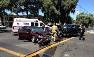
As a practical matter, what could Virginia do to make streets and roads safer than they already are? First, take a look at where the traffic accidents occur. The NHTSA study indicates that intersection crashes resulted in 8,682 fatalities, 2.2 million injuries and 10 million damaged vehicles in 2010 — more than half of all crashes, a quarter of all fatalities, 50% of all economic costs and 45% of all societal harm.

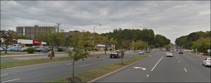
I would hypothesize, subject to verification, that a disproportionate number of accidents take place in a relatively small sub-set of roads — typically commercial corridors that combine relatively high speeds (45 miles per hour) with lots of traffic signals, cut-throughs and driveways creating complex traffic patterns where cars collide at relatively high speeds. Many accidents could be remedied by better street design — turning our stroads (street-road hybrids) into Complete Streets that accommodate buses, pedestrians and cyclists intermingling at lower and safer speeds.

The other big killer category is “roadway departure crashes,” in which people run off the road. This accounted for 18,850 fatalities, 795,000 injuries and 2.4 million damaged vehicles, accounting for 26% of all economic costs and 35% of societal harm. Many of these accidents take place on windy, two-lane, undivided roads. Surely it would be possible to reduce the number of these accidents through such measures as road-straightening projects, wider shoulders and better marking in the most accident-prone stretches. Continue reading

Urbanizing the Burbs: Fairfax Circle Plaza

rt50
by James A. Bacon

Route 50 through the City of Fairfax is a classic stroad, a street-road hybrid, that originated as a state highway and degenerated into a local access road for commercial development, with the result that it serves neither function — moving cars or providing local access — especially well. In a lengthy stretch around Fairfax Circle, the “highway” is flanked by disconnected, low-density and low-value development such as gas stations, fast food, auto dealerships, shopping centers and the like. It’s typical of the “suburban sprawl” development that has dominated Fairfax City and County, and the rest of Virginia, since World War II.

At long last, the stars are aligned to re-develop much of this corridor as high-value, higher-density, mixed-use property that will fill the city’s coffers with greater tax revenue at little offsetting cost — and create an attractive place where people are more likely want to live and do business.

fairfax_circle_plazaOn Tuesday, City Council approved a plan by Combined Properties build two apartment buildings with 400 units, ground-floor retail, and a 54,000-square-foot grocery store. Structured parking will replace large parking lots. Expanded sidewalks, buffers and a frontage road with parallel parking will create a pedestrian-friendly environment. While the plan has imperfections, the results will be vastly preferable to what’s there now.

Fairfax Circle typifies the re-development that is taking place in “suburban” counties across Virginia and much of the country. As I explained in “The Evolution of the Burbs,” suburban jurisdictions are selectively urbanizing. Low-value commercial property on major thoroughfares like Rt. 50 (Lee Highway) will be re-developed in mixed uses, at higher densities, with more walkable surroundings, often with access to mass transit. (Fairfax Circle is within walking distance of the Vienna Metro.) Yes, growth is occurring in the “suburbs” but it’s looking more like Fairfax Circle and less like the shopping centers and cul-de-sac subdivisions of yore.

Cities and counties can either allow this re-development to occur in a haphazard way, or they can create a planning framework for the pieces to fit together. The City of Fairfax completed but never passed a Fairfax Boulevard Master Plan. As Douglas Stewart writes in Greater Greater Washington:

Many of the project’s shortcomings stem from the fact that Fairfax City still does not have a clear plan for Fairfax Boulevard. An adopted plan that sets forth clear guidelines for street connectivity, green infrastructure, affordable housing and other elements would make the process easier for applicants and more beneficial for the city.

Rules governing street connectivity and storm-water infrastructure are essential to ensure that future projects integrate harmoniously with Fairfax Circle. An affordable housing component is more problematic; it will add costs, creating a higher financial burden for re-development without really addressing the affordability issue. (See Emily Washington’s essay, “How Affordable Housing Policies Backfire.”) Be that as it may, we’ll be seeing a lot more development like this and, for the most part, that’s a good thing.

Will Google Cars Boost City Productivity?

Prototype of the Google self-driving car.

Prototype of the Google self-driving car.

The spread of Self-Driving Cars (SDCs) will lead to tremendous increases in the productivity of cites, argues Brian Wang in The Next Big Future blog. Wang builds his argument on claims by Google that the ability of SDCs to drive faster and closer with greater safety than human-driven cars will effectively double the capacity of roadways. In turn, doubling roadway capacity will eliminate a major limit to urban density. Doubling effective density, according to a variety of economic research, will result in a 12.5% increase in productivity. Furthermore, in today’s conditions, doubling a city’s population requires only an 85% increase in infrastructure to support it; strip out the need to upgrade roads, and infrastructure spending is even less. “In general,” writes Wang, “creating and operating the same infrastructure at higher densities is more efficient, more economically viable, and often leads to higher-quality services and solutions that are impossible in smaller places.”

Sounds great. Just one problem. Wang ignores the crucial distinction between roads and streets. Roads and highway, designed for the efficient movement of automobiles between far-apart destinations, very well could double in capacity if Google’s calculations are correct. However, city streets serve a very different function, especially as the Complete Streets movement takes hold. Streets provide local access to cars, buses, bicycles and pedestrians alike; they also help define public spaces. Doubling the speed of cars in city streets would displace other modes of conveyance despite ample evidence that people are yearning for more walkability. In other words, it won’t happen. City dwellers won’t let it happen.

It is appropriate to think of SDCs as a solution to the problem of congested roads and highways, and far-sighted transportation planners should begin scaling back their estimates of how much new construction will be needed over the next 20 years to achieve desired levels of mobility. But it would be folly to turn city streets over to SDCs at the expense of bikes, buses and pedestrians. That would destroy cities’ greatest competitive advantage in the emerging knowledge economy.

— JAB

The Evolution of the Burbs

Leigh Gallagher, assistant managing editor of Fortune magazine, made a big splash last year with her book, “The End of the Suburbs.” While she added little new to the urbanism vs. suburbanism debate, she did a superb job of articulating and popularizing the urbanism side of the argument. The title is misleading — probably dictated by her publishers looking to make it more controversial — in that Gallagher doesn’t predict the demise of the suburbs but rather their transformation. In the TED speech shown above (Hat tip: Strong Towns blog) she makes the case that the “suburbs,” by which she means the lower-density, autocentric communities built since World War II, will take on more traditional urban forms: more density, greater walkability, less cookie-cutter building types.

It would be safe to say that Gallagher sees little future for the low-density “cul de sac” suburb and predicts a revival of the older, trolley-stop or train-station suburbs of the early 20th century where houses were close together, blocks were lined with sidewalks, and there were local downtowns that people could walk to. “A lot of people think these kinds of suburbs are really well positioned for the future,” she says. Whether you call them “urban burbs,” or “vintage burbs,” (after the movie) “Silver Lining Playbook burbs,” or, following the The New York Times, “hipsturbia” (gag), they represent a mid-density development type that Americans will see more of.

Many people want the real thing — the excitement of living near the urban core. But due to NIMBYism and urban zoning restrictions, the supply of urban-core housing can’t come close to keeping up with demand. Inevitably, the interest of developers and home builders will shift to the vintage burbs. Unfortunately, NIMBYism is likely to limit re-development there as well. If the urbanists are right about housing demand drying up on the metropolitan fringe, the action by necessity will shift to the in-between burbs.

The pattern that seems to be emerging is this: The new suburban regime will protect existing neighborhoods of Single Family Dwellings from re-development because most people who live in them like their lifestyle and want to protect it. But the market for new cul de sacs will shrink markedly as lifestyle preferences shift. We will see more mixed-use development, apartments, condos and townhouses in areas once zoned for commercial and light industrial where re-development at higher density does not threaten the integrity of existing neighborhoods. There is enough land dedicated to these uses that Virginia (and the rest of the United States) should be able to accommodate population growth for the next two or three decades with relatively little conflict.

The great planning challenge of the early 21st century will be re-developing and retrofitting these “suburban” places .

— JAB

Save Lives: Treat City Streets Like City Streets

dangerous_by_designby James A. Bacon

In the decade between 2003 and 2012, more than 42,000 pedestrians died on American streets and roads. That’s more than 16 times the number that died in earthquakes, floods, hurricanes and tornadoes. While natural disasters attract national attention, pedestrian fatalities are buried in the back pages, if they’re noted at all, even as the incidence of pedestrian deaths has spiked in recent years.

Pedestrian accidents are far from inevitable, however. Thousands of fatalities along with untold injuries can be mitigated by street design adapted less to the needs of automobiles and more to the needs of people, contends the National Complete Streets Coalition, a program of Smart Growth America, in a publication released Monday, “Dangerous by Design 2014.”

Vehicle speed was a major factor in the pedestrian fatalities. “Where the posted speed limit was recorded, 61.3 percent of pedestrian fatalities were on roads with a speed limit of 40 mph or higher,” states the study. “This figure compares to just 9 percent of fatalities that occurred on roads with speed limits less than 30 mph.”

Sunbelt communities top the list of the most dangerous places to walk in the country. “These places grew in the post-war period, mostly through rapid spread of low-density neighborhoods that rely on wider streets with higher speeds to connect homes, shops and schools — roads that tend to be more dangerous for people walking.”

Orlando, Tampa-St. Petersburg, Jacksonville and Miami-Fort Lauderdale — all Florida metros — nail down the top four spots in the study’s ranking, which compares the number of pedestrian deaths per 100,000 population and adjusts by the percentage of people who walk to work. Among the 51 largest metro regions in the country, Richmond scored the 19th highest Pedestrian Danger Index, with 1.32 annual pedestrian deaths per 100,000 in 2003-2012. Washington ranked 35th and Hampton Roads 36th.

“We can build and design our communities to protect us while walking,” said Stefanie Seskin, deputy director of the National Complete Streets Coalition in a conference call releasing the report yesterday. “Treat city streets like city streets, not like highways. … Auto-oriented streetscapes are not only uninviting and uninspiring but downright dangerous.”

richmond_fatalitiesLocal government officials need to distinguish between streets, which function as public spaces accommodating people, cars and bicycles alike, and roads, which function mainly for the movement of cars at higher speeds. The greatest threat to pedestrian safety occurs in street-road hybrids (stroads), typically commercial strips where people intermix with cars traveling at fairly high speeds. The map of the Richmond region at left shows the concentration of pedestrian fatalities in the region’s major stroad corridors: Broad Street, Midlothian Turnpike and Rt. 1. The peculiar mix of retail, restaurant and office activity along these corridors induces people to walk across streets ill suited to pedestrian traffic with frequently tragic results.

The same pattern prevails across the state. Stewart Schwartz, executive director of the Coalition for Smarter Growth, cited the example of an elementary school principal in Loudoun County who was killed last year trying to cross a four-lane, 35 mph road. “As more people make the sustainable and healthy choice to leave their cars at home, we are unfortunately seeing more tragic crashes,” he said in a press release yesterday. “Decades of car-oriented design has made it hazardous in many of our communities simply to walk to school, work, or shopping.”

What public policy approaches are available to curb the incidence of pedestrian deaths? One option, pursued most vigorously in Florida, is to step up education and police enforcement of speed limits and laws that require cars to yield at crosswalks. A less authoritarian approach is to alter street design. There is a pervasive body of thought that wide roads, wide lanes and the absence of visual cues induce motorists to drive faster than posted speed limits. Proper design discourages pedestrians from attempting to cross high-speed roads and encourages cars to drive much slower on people-friendly streets. Continue reading

Mo’ Money for a Broken System?

broken_downby James A. Bacon

The nation’s roads and bridges have a feevah and Josh Voorhees has a cure: mo’ money for the federal Highway Trust Fund. Writing in Slate, Voorhees highlights Congress’ inability to find new revenue sources to replenish the fund, which faces an $18-billion-a-year shortfall every year over the next decade.

“Current tax rates—18.4 cents per gallon of gasoline, 24.4 cents per gallon of diesel fuel—aren’t enough to prevent America’s roads from crumbling and bridges from collapsing,” he writes. Bridges are structurally deficient, he reminds us, urban highways are congested and too few Americans have access to mass transit. Adding urgency to the situation, he notes that America’s road system is ranked only 18th globally — the U.S. is losing its economic competitiveness!

The good guys in his article are those who implemented, or at least advocated, higher federal taxes for transportation. Alas, he laments, “Recent history suggests such days of good policy winning out over good politics are behind us.”

The fact is, there hasn’t been good transportation policy at the federal level for the decades. The federal gas tax, enacted by Herbert Hoover, was necessary to pay for construction of a system of national highways. That it did, quite successfully. But federal programs never declare, “Mission Accomplished.” They morph into something new. And the “Highway” Trust Fund has evolved into a program that doesn’t just underwrite construction and maintenance of highways but one that subsidizes mass transit and all manner of other non-road spending, not the least of which is the cost of administering the federal program itself.

The best thing Congress can do is dismantle the federal transportation bureaucracy and transfer the gas tax revenue to the state transportation bureaucracies. It is axiomatic here in Virginia that federal money bogs down the lengthy approval process for transportation projects with even more bureaucratic process and, thanks to the strings attached, runs up the construction costs. Cutting Uncle Sam out of the loop would save both time and money.

I harbor no illusion that states are any less likely to spend money on boondoggles than Uncle Sam. While the states are closer to “the people,” they are also closer to developers and other special interests who lobby for projects that benefit them at the expense of the public. But cutting the federal strings and overhead at least would make the boondoggles cheaper.

The conventional wisdom conveyed by Voorhees’ article is riddled with other assumptions that I do not accept such as, for example, the notion that the federal government should do more to offset maintenance under-funding. The under-funding of maintenance is a problem, perversely enough, that the Highway Trust Fund helped create. The program entices states to undertake expensive mega-projects by sharing the up-front capital cost. States leap for the “free” money to help cover the up-front costs — the problem is especially prevalent with mass transit projects — oblivious to the fact that new capacity adds to ongoing maintenance and operations costs. States overbuild their transportation systems, maintenance & operations obligations escalate, and they scrimp on repairs to find money for the next new project.

Another issue: In the business world, corporations continually review their portfolios of assets, sloughing off divisions and subsidiaries that don’t justify continued investment. When was the last time the state or federal government ever reviewed its portfolio of transportation assets? Once a road gets built, it never gets downsized. How many lane-miles of highway serve counties with dwindling populations? How many country roads revert from paved to gravel? The United States has erected a system that only grows and never retracts. As long as Uncle Sam is doling out cash, states have little motivation to reconsider.

These and other travesties can happen only in a country in which citizens are convinced that “someone else” should pay to build and maintain everything from city streets to highways, bicycle lanes to light rail lines… a country in which there is no accounting for life-cycle costs… a country in which transportation planning is divorced from land use planning… a country in which accountability for results is diffused between federal, state and local governments…

I don’t mean to pick on Voorhees — many others think as he does — but the idea that raising taxes is the default solution to our nation’s transportation challenges is ludicrous beyond words. The transportation system does need more investment. But until the ramshackle structure for financing highways, bridges and rail is fixed, Americans should have no confidence that the money will be well spent.

Putting the “Garden” in Rain Garden

Photo credit: Lewis Ginter Botanical Garden

Fall view of West Island MP. Photo credit: Lewis Ginter Botanical Garden

This July Virginians will start spending billions to meet tough new storm-water regulations. Lewis Ginter Botanical Garden wants to demonstrate best practices that save the bay – and look really good doing it.

by James A. Bacon

About a decade ago the leadership of the Lewis Ginter Botanical Garden, an institution known mainly for its formal gardens and conservatory of exotic tropical plants, began re-defining its mission. The new vision called for showcasing how Richmonders and Virginians might address endemic environmental problems such as invasive species and pollution caused by storm water run-off. It was a hard sell at the time, and the 2007-2008 recession dried up traditional sources of philanthropic funding. For years the $9 million project stalled.

But the economy has improved, donations have picked up and the “Streams of Stewardship” vision couldn’t be more timely. The plan calls for reclaiming a stream running through the garden’s 80-acre property, replacing turf lawns with native meadow grasses and using rain gardens to reduce parking-lot run-off – exactly the kinds of things that Virginians will have to do to meet strict new water standards designed to clean up streams, rivers and the Chesapeake Bay.

wetlands

View of West Island Garden. Photo credit: Lewis Ginter Botanical Garden

Come July Virginia localities will have to get serious about reducing nitrogen, phosphorous and sediment borne by storm water run-off.  Localities will have 15 years to meet tough state-federal goals for the Total Maximum Daily Load (TMDL) of those pollutants detected in their waterways – achieve 5% reduction in the first five years, another 35% reduction in the second five years, and the final 60% reduction in the third five years. Nobody knows for sure how much it will cost or where the money will come from.

The relatively easy part will be implementing tighter regulations for new development. “The new standards are very stringent but well vetted, accepted by the developer community,” says Chris Pomeroy, chief counsel for the Virginia Association of Storm Water Agencies. As long as developers know the costs of new Best Management Practices up-front they can incorporate them into their business plans. “There’s peace in the valley on that subject now.”

The hard part, says Pomeroy, will be fixing old development. “It’s cheaper to build it right in the first place. It’ll cost something to do new development but the corrective action will cost far more.” The state Senate Finance Committee estimated that retrofitting the state could cost $15 billion. But even that is little more than a wild guess.

If Virginians are going to spend billions of dollars on retrofits, they might as well make sure the end result looks good. Lewis Ginter President Frank Robinson wants the botanical garden to be a living demonstration of the positive possibilities. With a little extra attention to detail, he says, storm-water remediation projects can become beautiful community assets.

In the 1990s and 2000s Lewis Ginter completed a series of improvements – two man-made ponds, a 1.5-acre man-made wetland and retrofitting building roofs to harvest and recycle two million gallons of rainwater annually. Not only did these investments help control water run-off, they made the facility water-independent by using rainwater to irrigate the grounds rather than expensive treated municipal water. By saving the need to purchase 500,000 gallons of  year from Henrico County, those investments offered an attractive Return on Investment.

The next step is to re-work the formal lawn near the entrance and west of the conservatory. Ornamental lawns always will have a place in Lewis Ginter’s formal gardens, explains Robinson, but maintaining vast swaths of turf is an outmoded idea inspired by 18th-century European landscaping models no longer appropriate for Virginia. Lawns of close-cropped green grass are unknown in the natural world and they can be maintained only through the expensive application of fertilizers. Grass lawns absorb little rainwater. The soil is typically compacted and the grass itself has little vegetative mass to hold the water. Rain just runs off horizontally, carrying the chemicals into the watershed where they feed the algae blooms that rob the water of life-giving oxygen.

Industrial discharges are tightly regulated and farmers are getting savvy about managing their fields, says Robinson. Lawns are the last great frontier of cleaning the Chesapeake Bay. The lawn of any individual homeowner seems small but multiply that size by a million suburban houses and the numbers get big. “There is more acreage in lawn in this state than any crop. … If it were a corporation flushing chemicals through their manufacturing plant, we’d be up in arms.” Continue reading

Map of the Day: Cycling to Work

bicycling_to_work

The number of U.S. workers who traveled to work by bicycle increased from about 488,000 in 2000 to about 786,000 in 2008-2012, the largest percentage increase of any transportation mode, according to a new report issued by the U.S. Census Bureau based upon its annual American Community Survey. Fully one percent of the population in the nation’s largest cities commute by bicycle now.

The percentage of Virginians who bicycle to work is lower than the national average, as can be seen in the map above published by the Census Bureau.

Males are twice as likely to bicycle to work as women nationally, and lower income workers are more than two to three times more likely than Americans in higher income brackets. Hispanics and white are twice as likely to use bicycles as African-Americans.

The political economy of bicycling. There are two closely aligned constituencies that agitate for making American cities more bicycle friendly: environmentalists and urbanists. The enviros love cycling because it causes no pollution and emits no greenhouse gases. Urbanists, most of whom are environmentalists as well, also support cycling because it takes automobiles off the road, ameliorating congestion and reducing the demand for automobile parking. Both of these constituencies skew heavily to the educated white demographic.

However, Hispanics are more likely than any ethnic group to ride bicycles to work. That’s all the more interesting when you consider how in many regions Hispanic immigrants have settled in the suburbs. By contrast, African-Americans are less likely than any ethnic group to bicycle to work. Is there a cultural difference here? Do Hispanic immigrants come from countries where riding bicycles to work was a prevalent form of transportation? I don’t know, but it’s worth looking into.

Regardless, I would suggest that the bicycle lobby — I can only hope that it will one day grow to become known as Big Bicycle — expand its advocacy of bicycles beyond the environmental and urbanist justifications, as legitimate as they are. Bicycles also should be a means of mobility for the poor. There is no cheaper form of transportation. Even poor people can afford to purchase bicycles; charitable organizations in Richmond are collecting used bicycles and giving them to poor people for free. For poor workers lacking access to automobiles, bicycles expand the range they can cover on foot by a factor of three or four.

All I hear from the anti-poverty groups is the need to expand and subsidize mass transit. You could turn the average city into a bicycler’s paradise for the fraction of the cost of adding Bus Rapid Transit or light rail — and you wouldn’t incur the same operating deficits year after year. As for Republicans, conservatives and others who are reflexively skeptical of investing in bicycle infrastructure, I’m surprised they haven’t positioned bicycles as an alternative means of helping the poor access jobs at a fraction of the cost. Let’s see a little more imagination, guys!

— JAB

Map of the Day: Where the Cyclists Are

Source: Strava Global Heatmap

Source: Strava Global Heatmap. (Click for larger image.)

Strava Labs maintains a database of where runners and cyclists using its smart-phone fitness app are running and riding. The data set includes nearly 77 million rides and 20 million runs. The heat map above shows where cycling activity is the most intense across the state. (Sorry about cutting off Southwest Virginia and the Virginia Creeper Trail!) Clearly, more cycling occurs where there are more people — the activity occurs mainly within metropolitan and micropolitan regions. The biggest surprise to me is how strong, relatively speaking, cycling is in the Roanoke-Blacksburg area. Less surprisingly, the activity is strong in the college towns of Charlottesville and Harrisonburg. east_coast 
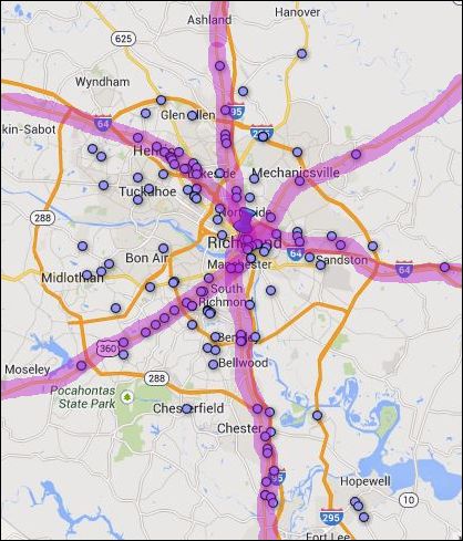
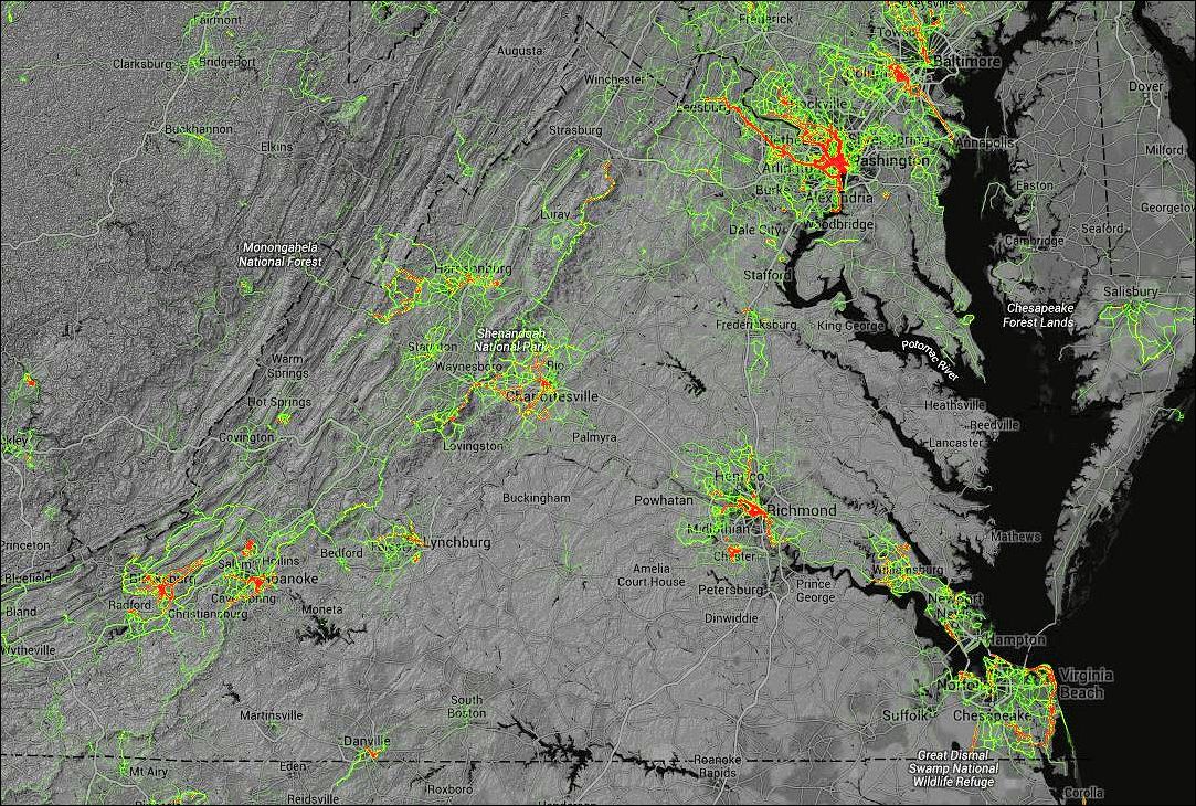
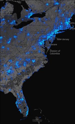
A higher altitude perspective gives quite a different picture. Virginia looks like a relative wasteland set between the Washington-Boston corridor and even the Raleigh-Atlanta corridor. The City of Richmond may have hosted the college cycling championship and is prepping to hold the world cycling championship but the metropolitan region barely registers on the heat map. Hampton Roads also makes a poor showing. (Hat tip:Streetsblog USA.) — JAB

A Timely Reminder of the Anti-Agenda 21 Distraction

agenda21by James A. Bacon

Here in Virginia, the anti-Agenda 21 zealots have managed to stay out of the headlines for quite a while. I don’t know if that’s because they are quietly re-energizing themselves or if the movement is falling apart. But it never hurts to be reminded of the bizarre nature of this populist splinter group, which has done so much to obfuscate the issues surrounding growth and development in Virginia and distract from the task of articulating a positive, forward-thinking set of conservative principles to guide governance at the local-government level.

That reminder comes from a new report from the Southern Poverty Law Center, “Agenda 21: the U.N. Sustainability and Right-Wing Conspiracy Theory.” The report documents how the anti-Agenda 21 movement, which regards the Agenda 21 project of the United Nations as a radical environmentalist plot to deprive Americans of their property rights and way of life, has thrived on the paranoid fringe of conservative thought.

Lead author Heidi Beirich documents the spread of anti-Agenda thinking from its fountainhead, Tom DeWeese, head of the American Policy Center in Remington, Va., to the Constitution Party, the Constitutional Sheriffs and Peace Officers Association, the John Birch Society, neo-Nazis and all manner of obscure, grass-roots organizations. Many of these are groups that mainstream conservatives do not want to be associated with. Indeed, many are a downright embarrassment to conservatives, for their ideological affinity for small government allows liberals and progressives to paint the broader small-government movement as a collection of cranks and weirdos.

Nowhere is that dynamic more damaging, however, than the debate over Climate Change, the very issue that animates the anti-Agenda 21 populists, because an inordinate fear of global warming underpins many liberal/progressive initiatives in the realm of transportation, zoning and land use.

In truth, there are legitimate questions relating to how global temperatures are measured and calculated. There are issues regarding how much global warming can be attributed to human activity and regarding the efficacy of the climate-model projections that underpin climate alarmism. There is disagreement over the extent to which global warming will harm humanity and the environment. And then there are questions outside the realm of science regarding how best to respond to the challenge of climate change — re-engineering the modern industrial economy to limit CO2 emissions or simply adapting to change if and when it occurs. But of all the issues that serious people raise about climate change orthodoxy, the existence of an international conspiracy to impose the United Nation’s sustainability/social justice agenda upon the American people is not one of them.

I addressed the flaws in the anti-Agenda 21 thinking (it is too incoherent to dignify with the appellation of a “theory”) two months ago in a white paper, “A Distracting Doctrine.” The anti-Agenda 21 literature is replete with cherry-picked data, leaps of logic and an astonishing lack of awareness of conflicting information. This scatter-shot body of thought is so embarrassingly unpersuasive that it actually harms the cause of other skeptics mounting a serious case against climate alarmism.

Worst of all, the anti-Agenda 21 movement is an immense distraction. Focusing on a supposed conspiracy is a losing proposition: first, because there is no conspiracy and it is difficult to persuade people to believe in something that does not exist; second, because global warming orthodoxy has many demonstrable weaknesses that people should be talking about but aren’t, in part because they’re distracted by Agenda 21; and third, because the anti-Agenda 21 movement offers no solutions to the challenges of local government in the 21st century.

The Agenda 21 contras have nothing useful to say about how Virginia regions and local governments should address the challenges of fiscal stress, congested roads and highways, quality of life, local environmental degradation and other issues affected by our built environment. The liberal/progressive answer, driven by a conviction that climate change is a threat demanding the investment of billions of dollars to reduce CO2 emissions, is to strive for environmental sustainability. As I have argued on this blog, conservatives should hammer on the themes of fiscal responsibility, livability, economic development and local environmental issues like air and water pollution. It’s hard to do that when the anti-Agenda 21 crowd is attracting attention by swatting at figments of their imagination.

Rise of the Post-College Town

millennials
Every community covets the Millennials, especially those with education, skills and tech savvy who do so much to stimulate entrepreneurial economic growth. USA Today has surveyed the coutry to see which “cities” (urban core jurisdictions, not metro regions) do the best job of luring Millennials. And it turns out that Virginia cities do pretty well.

Arlington tops the list (even though it’s a county and not a city), while Alexandria ranked No. 3. No surprise there. But how about this — Norfolk scored 13th out of the 288 cities surveyed and Richmond scored 18th.

As is always the case, semantic confusion surrounds the use of the word “city.” Chesapeake and Virginia rank disappointingly low on the list. But Chesapeake and Virginia Beach are not urban-core jurisdictions; under Virginia’s unique system of government, they are classified as cities even though their sociological profiles are all suburban. They are bedroom communities geared to households raising children, not urban hipsters.

Greg Toppo and Paul Overberg with USA describes a trend they describe as the “post-college town” — places where college grads head to look for a job and sink roots.

This is a new kind of city, born of deep demographic shifts and the power of technology. Where traditional college towns have long attracted young people who get an education and then leave, another kind of town is emerging: the post-college town.

“These places seem to be built for people, not for automobiles,” says University of Nevada-Las Vegas demographer Robert Lang. “And the 20-somethings love the people, not the automobile.”

The USA Today rankings are based on the ratio of the number of people 20-29 to the number of teens. Cities with high ratios suggest that a large number of Millennials have moved in. Some high rankers are to be expected — Cambridge, Mass. (No. 2.), San Francisco (No. 5) and Seattle (No. 6). But there some surprises like Tallahassee, Fla., Fargo, N.D., Springfield, Mo. — not to mention Norfolk and Richmond, which few people regard as magnets for young people.

Virginia has many, many problems, as Bacon’s Rebellion bloggers make abundantly clear. But the ability of Virginia cities to attract and retain educated young people bodes well for the future of the Old Dominion.

— JAB

The Simple Ingredients of a Good Public Space

nyc_street
What makes a good urban public space? It takes more than a plaza, which can be barren, inhospitable and desolate. The fountains, as shown here on Park Ave. in New York, are a definite bonus. But the critical ingredient is having somewhere to sit, even if it’s as simple as a set of shallow steps. I offer this example not because it is extraordinary in any way but because it is so totally ordinary. Cities and towns don’t have to spend millions of dollars on public art and landscaping. All they need is a vibrant street with lots of foot traffic and a place to eat lunch outside on a sunny spring day.

— JAB

Planners Say Yes to Shockoe Bottom Condo

libbie_hill

View of the James from Libbie Hill Park. Pretty nice… if you don’t mind that grainery.

by James A. Bacon

Libbie Hill Park sits on the crest of a hill overlooking the James River. On that spot in 1737 William Byrd II famously looked upon the turn in the river, was struck by its resemblance to Richmond-upon-Thames outside London, and decided to give the new city founded nearby the name of Richmond. It is understandably a view that preservationists want to protect.

The-James-at-River-Bend-from-Cary-Street

View of The James at River Bend from Cary Street. Image credit CHPN.

But the Richmond Planning Commission approved Monday a special use permit to build a 16-story condominium building, The James at River Bend, just west of the view from Libby Hill Park. That decision follows approval earlier this month of an office complex on the eastern side of Libby Hill. Some conservationists are up in arms, and I sympathize. Some things are worth preserving. Yet I agree with the planning commission’s decision. Shockoe Bottom is an appropriate place for development at greater intensity.

The Richmond metropolitan region has reached a turning point. After decades of scattered, low-density growth giving the region one of the worst sprawl indexes in the country, the momentum of growth has shifted back to the urban core. Richmond’s downtown and surrounding precincts have accommodated significant population growth through the expedient of renovating an extensive stock of old warehouses, offices and industrial buildings. That strategy has been economically feasible thanks to state and federal historic tax credits. But the inventory of old industrial buildings is running low. In the future, developers will have to build taller buildings.

David White, president of Historic Housing LLC, explained during the permit hearing that he could not finance the project without the building height and the views that commanded high condominium prices. “I can’t make the numbers word,” he said. “The only way I can afford to build the build is to get the dollars that come from the height.”

Richmond, Henrico County and Chesterfield County all have to come to terms with the prospect of higher density development and taller buildings. It is the natural order of metropolitan evolution and cannot be avoided except at great cost. Richmond’s urban core needs higher density. Condominium towers generate high tax revenues without major offsetting infrastructure costs. They also provide the density needed to support the Bus Rapid Transit system that city planners want to run along Broad Street. Failure to densify the Broad Street corridor will doom BRT to economic failure and perpetual subsidies. And the alternative to building “up” is to build “out” — creating more sprawl with its voracious needs for expensive new infrastructure.

Those considerations trump the marginal impact of the condo project on the view from Libbie Park, as even the Historic Richmond Foundation agrees. The hard decision will come when someone proposes to erect a building that will blot out the river. Until that time comes, the trade-off is an easy one to make.

Smart Growth for Custom-Minded Conservatives

main_streetby James A. Bacon

As I have endeavored to develop a conservative vision for Smart Growth, I have relied primarily upon conservative principles with a libertarian slant — limited government, fiscal conservatism, free markets and the like. But there is a vast realm of conservative thinking that I have neglected, which William S. Lind, director of the Arlington-based American Ideas Institute, has reminded me of in today’s post on the Center for Public Transportation blog.

In that post, Lind has kind words to say about Bacon’s Rebellion and our offshoot blog, Smart Growth for Conservatives. But he also expands the case for Smart Growth beyond the one that I have made: He appeals to the idea of conservatism that favors institutions that have grown up over time, as embodied in customs, traditions and habits. In the realm of land use planning, he invokes the golden age of American urbanism that reached its apex in the street car era before zoning codes mandated separation of where people lived from where they shopped or worked by distances too great to walk.

Traditional neighborhood development, Lind contends, fostered a sense of community — and community is a core conservative value. Community refers to informal arrangements in which citizens interact in the civic sphere, building bonds of trust, collaborating to achieve goals of mutual benefit and enforcing community norms without the need for government intervention. He writes:

Why do we desire community? Because traditional morals are better enforced by community pressure than by the clumsy and intrusive instrument of the law. But community pressure only works where there is community. If you do not know your neighbors, what do you care what they think? We want people to care what their neighbors think.

Lind then observes that a conservative view of Smart Growth differs from a liberal view in preferring free-market mechanisms and a level playing field (the arguments that I have articulated) and in rejecting the Left’s celebration of “diversity, or the mixing of races, ethnic groups, income levels, and cultures in ways where everyone must live cheek-by-jowl.” When “diversity” occurs as a result of social engineering, rather than the natural coming of people together, it undermines community. “Community, for us,” writes Lind, “is far more important than any putative benefits from ‘diversity,’ benefits that seem entirely ideological in nature.”

I would elaborate that the Left tends to worship diversity as an abstract concept with little heed for its actual consequences. In the real world, as I have blogged recently, some of the most segregated places in the United States are the most politically liberal. Liberal policies (such as giving government more power to control land use) are associated with the most illiberal results. Ironically, while a conservative version of smart growth would eschew “diversity” as a goal, by eliminating exclusionary zoning and building communities based on shared values and trust, Smart Growth conservatism could do more to erode racial and ethnic segregation than all the judicial decrees and government programs favored by liberals.

Lind, who co-authored a study with Paul Weyrich and New Urbanism guru Andres Duany that explored commonalities of conservative and the New Urbanism, has tapped a rich new vein of thought and commentary on why conservatives should embrace Smart Growth. Let’s hope he continues to develop this line of thinking.

Re-imagining Sunnyvale

SONY DSCby James A. Bacon

Silicon Valley appears to be moving in fits and starts toward more rational land use, creating denser, more mixed-use, better-connected communities appropriate to a region with extraordinarily high land values. As a casual visitor to the region, I don’t pretend to speak with any authority on the trend but I can provide a couple of case studies on how change is happening. The good news for businesses and residents of Silicon Valley is that change is occurring and that the new is better than the old. The bad news is that change isn’t coming fast enough, and the new stuff being built probably could work better.

Proposed design of Apple mothership

Proposed design of Apple mothership

Projects like the planned 2.8 million-square-foot Apple headquarters complex, one of the final legacies of Steve Jobs, tend to grab the lion’s share of attention. The proposed headquarters, snarkly dubbed the “mothership” for its futuristic design, will be an architectural masterpiece. Apple says the facility will produce as much energy as it consumes and its floor plan will foster creative collaboration. But the complex will be a self-contained campus. While it may encourage collaboration internally, its isolation will not promote interaction with entities outside the corporation. And while the facility itself may be  carbon neutral, plans include a vast underground parking lot to accommodate thousands of employees who will be commuting (and burning gasoline) by car.

Yes, the Caltrain station provides bike racks -- and people are using them. But look carefully at this picture. Beyond the bikes the valuable land adjacent to the train station is consumed by surface parking lot.

Yes, the Caltrain station provides bike racks — and people are using them. But look carefully at this picture. Beyond the bikes, the valuable land adjacent to the train station is consumed by surface parking lot.

It’s not as if Silicon Valley lacks mass transit. As one would expect of a California locale, the region has made significant investments in rail and bus. A Caltrain track runs from San Francisco to San Jose with several stops along the way. The Santa Clara Valley Transportation Authority runs bus lines throughout. There even appears to be some mixed-use clustering occurring around the transit stations. If the region is to address its long-term challenge of providing more affordable housing and reducing traffic congestion, it will need fewer Apple motherships and more of the uncelebrated development like that which is occurring around the Sunnyvale Caltrain station.

The Caltrain stop is served by an attractive bus station. Too bad nobody was using it when I happened by.

The Caltrain stop is served by an attractive bus station. Too bad nobody was using it when I happened by.

However, local planners and developers in the region also will have to work on their execution. Last week I had spent some time touring the district around the Sunnyvale station. Local planners have done some things right. But my quick and superficial impression is that the district will fall short of potential.

Planners appear to be checking off the smart growth list — light rail. Check. Covered bus stops. Check. Mixed-use buildings, grid streets, bicycle racks, parks, underground parking… Check, check, check.

Sunnyvale open space -- attractive but empty.

Sunnyvale open space — attractive but empty.

But the key players appeared to have paid less attention to how all the pieces fit together. The biggest problem is that the train station is surrounded by parking lots and an empty park-like space. The mixed-use, multi-story buildings are all pushed back from the station. Given the reluctance of people to walk more than a quarter mile to transit (roughly 1,500 feet), the most valuable space is located right next to the station. That’s where the greatest density should be. But in Sunnyvale that’s where the lowest-value land uses are located.

The streets and public spaces of this transit-oriented district were empty. The problem wasn’t just the time of day — late morning and lunch-time on a Wednesday. One street was really hopping: South Murphy Avenue. The design was classic New Urbanism with wide sidewalks, on-street parking, narrow lanes, street furniture, ornamental trees and sidewalk dining. The place was packed. I don’t know how people got there, whether they walked or they drove, but the restaurants were jammed. Continue reading