Tag Archives: Digital cities

The Smart Parking Revolution Gains Momentum

Fear factor

Fear factor

by James A. Bacon

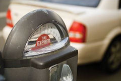
No one likes paying for parking, but the prospect of parting with a buck or two is nothing compared to the hassle of rummaging through your pockets, in your glove compartment or under the floor mats for stray coins. The only thing worse is worrying about your time expiring, dashing outside and feeding the meter to avoid getting a ticket. It is fair to say that the lack of ubiquitous, hassle-free parking is one of the most serious competitive disadvantages of compact urban development everywhere.

But the times, they are a’changing. Parking, once a lazy backwater of economic innovation — the last “big thing” in parking, meters, dates back to 1935 — has become very hot. A slew of start-up companies like Parkopedia and Parking Panda (profiled here) are making it easier for drivers to find parking spaces, be they located on-street, in parking lots, in garages or in someone’s private driveway. Now another company, Applied Telemetrics, is making it more convenient than ever to pay for parking. No more fumbling for coins. A device on the car can determine exactly which space you’re in and automates the payment to your account.

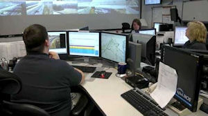
The implications for smart growth are tremendous. Local governments, and the public they serve, stand to gain in several ways. First, the new tools will reduce traffic congestion caused by people circling around and looking for a place to park. Second, the greater ease of finding a parking space and paying for it will make downtowns and other compact urban areas more hassle-free destinations. Third, the technology will allow local governments to optimize the balance between maximizing commerce and minimizing real estate dedicated to parking, a low value-added activity. And fourth, local governments can generate more revenue from on-street parking  at lower cost, reducing the need to raise other taxes and fees. Big picture bottom line: City fathers now have an awesome ne tool for building vibrant, walkable communities.

To gain more insight into the trend, I re-connected with Bern Grush, a principal with Toronto-based Applied Telemetrics. I had last chatted with him several years ago in his capacity as co-founder of Skymeter, which had developed technologies that could be used to administer Vehicle Mile Traveled (VMT) taxes, one of my pet causes. After several years of frustration, Grush concluded that VMT tax was a political non-starter in Canada as well as the United States. So, he and his partners re-purposed some of their technology to focus on parking. This time around, he’s not preaching to the unconverted. The market for smart parking is exploding.

According to a new report by Navigant research, the installed base of on-street smart parking spaces will surpass 950,000 worldwide by 2020. “The parking industry is going through its biggest evolution since the introduction of the first parking meters in Oklahoma City in 1935,” says Eric Woods, research director with Navigant. “It is being transformed by new technologies that are increasing operational efficiency and customer expectations, and by new perspectives on the role of parking within cities.”

Applied Telemetrics employs GPS and other technologies to determine roughly where a car is (within a yard or two) but adds proprietary algorithms that interprets the car’s motions to place it in a specific parking space or even a private driveway. The payment system functions similarly to EZPass. Customers load funds into a pre-paid account and deduct from that account when they park. “The driver simply parks where it is legal to park and walks away,” says Grush.

He concedes that it will take some time for the market to develop fully. Initially, the company is targeting frequent parkers, typically delivery trucks or service vans that might park in a 6 to 12 different locations daily. The convenience of paying automatically and precisely offers tangible productivity gains and savings. A second value proposition is helping municipalities manage loading zones whose use is limited to commercial vehicles.

Among the advantages of the Applied Telemetrics technology is the ability to generate useful data. For instance, the company can measure the amount of time drivers spend circling — driving around and around while they look for an open parking space. That kind of information can inform cities’ parking policies. If there is a shortage of parking, raise rates — encourage people to turn over their parking spaces more rapidly and raise more money in the bargain! If there is a surplus of empty spaces, lower rates!

Grush also contends that his PayBySky payment system can reduce the administrative overhead associated with enforcing parking, billing and collections, thus making the municipal enterprise more profitable. “On average [conventional] methods cost about 50 cents of every parking dollar to collect. Think of that next time you put $4 in a meter — $2 of it went to securing the $4. How dumb is that?”

Applied Telemetrics has embarked, or soon will, upon five pilot projects with municipalities and private operators in Canada, New Zealand and the U.S. Says Grush: “By making payment fair and easy, we are making it better for drivers and better for the city.”

Gearing up for the Smart Car/Road Revolution

by James A. Bacon

The automobile industry is undergoing the greatest technological revolution since… well, probably since the invention of the automobile. Cars are getting “smarter,” as in embedded with more powerful sensors and artificial intelligence, and they are getting more connected — with other cars and with roads, which are getting smarter as well. The way people drive 10 years from now will be radically different from the way they drive today, especially if driverless cars become the norm.

Will Virginia be ready? That’s the question I frequently ask on this blog. I don’t know the answer, but I will say this: If Virginia is prepared a decade from now, it will owe a lot to the Connected Vehicle/Infrastructure University Transportation Center, a research consortium supported by Virginia Tech, the University of Virginia, the Virginia Department of Transportation and Morgan State University.

Last week the Center strutted its stuff in Northern Virginia, putting on a demonstration of emerging connectivity technologies. Dave Forster has the story for the Virginian-Pilot:

To “connect” the car and the motorcycle, they equipped each with a small antenna and a black boxlike device. That allowed them to talk using what’s known as Dedicated Short Range Communications.

“Think of it as robust roadside Wi-Fi,” said Andrew Petersen, the director of technology development at the Virginia Tech Transportation Institute. …

Another device …looked like a large Wi-Fi router. …  That was the roadside part of the equation. It sent alerts to the vehicles as they passed, including one for a work zone and another for a stopped vehicle.

VDOT has installed 43 of those devices on a stretch of Interstate 66 and nearby roads close to the Capital Beltway. For researchers, it’s a real-world lab to test and collect data with a fleet of 12 connected vehicles, including four motorcycles, a semitruck and two SUVs.

Technology connecting cars and smart roads will be widely available to the public within five to ten years, researchers predict. The potential exists to make roads a lot safer, and perhaps to squeeze more capacity out of the existing road network.

Right now, the commonwealth is ramping up to spend billions of dollars to address Virginia’s transportation needs based on the assumption that future roads will be as stupid as today’s roads, that the revolution in automobile/infrastructure technology won’t change much of anything. Why? Because transportation funding is driven by a bureaucratic process in which projects inch through endless review and funding hurdles. Once a project enters this pipeline, rarely is it dropped. Projects conceived today, based upon today’s technology and land-use realities, will be extruded through this process a decade or two from now, when the transportation environment will be totally different. It’s depressing to think how many billions of dollars will be mal-invested.

A critical transportation challenge at this juncture is to figure out how to make that approval process more flexible, allowing future administrations to yank projects that no longer make sense and to accelerate projects that do.

Let’s Jump on the Peer-to-Peer Bandwagon

Vested interests in cities around the country are mobilizing to thwart a new generation of peer-to-peer technologies threatening to disrupt the lodging and transportation industries.

I have documented the difficulties of Uber, the e-hailing service (tap on your smart phone app and an Uber limo comes to pick you up), in Washington, D.C., where it has run afoul of the taxicab cartel. There must be at least a dozen more start-ups coming out of Silicon Valley or Europe — I’ve included YouTube shorts for RelayCars, Airbnb and Flightcar — that allow people to catch rides, share rides, rent someone else’s car or rent someone a room in someone else’s house.

As start-ups, these companies focus their efforts first on major markets like San Francisco, Chicago, New York and Washington. But they often run into regulatory barriers, as described here and here. Not surprisingly, the stakes are really big in those markets and the special interests are really entrenched.

So, here’s the idea. Why don’t second-tier cities (or regions) like Richmond and Hampton Roads make themselves hospitable to the peer-to-peers? Sure, there are local taxi services in each region but they have very small travel-share and they lack the political clout of their big-city counterparts. Why don’t we go out and promise to help work through any regulatory obstacles if these guys commit to establishing a serious presence in our regions.

We could end up with a greater variety of transportation and travel choices, which benefits everyone (except the entrenched competitors). And having more of these Internet-based services active in the region adds a coolness factor that the younger generation might find attractive. Yeah, I know, half or more of these companies will be out of business in two years. So what? The other half might transform their industries. And, as regions, we could send out a signal to the world: We’re open to competition, open to innovation. Check us out.

Another idea from the fertile (some might say febrile) brain of Jim Bacon…

Traffic Management Contract to Save $47 Million

VDOT operations center: from good to great.

VDOT operations center: from good to great.

by James A. Bacon

Outsourcing management of Virginia’s five traffic operations centers will save about $47 million over the life of the six-year contract and accelerate the adoption of state-of-the-art technology and best management practices. So says Dean Gustafson, state operations engineer for the Virginia Department of Transportation.

In a presentation yesterday, Gustafson briefed the Commonwealth Transportation Board (CTB) on the path-breaking contract, which, he said makes “Virginia very much a leader” among the 50 states in the field of traffic operations management.

The Virginia Department of Transportation announced the deal with Serco, Inc., last week, and the CTB formally approved the contract yesterday.

By replacing 11 existing contracts, the Serco contract allows VDOT to achieve economies of scale, achieve consistency of performance across the state and drive innovation, Gustafson said. The hand-off to Serco will take place over 180 days in the second half of this year, and the England-headquartered company will phase in its software over 24 months.

The most obvious benefit will be inter-operability of the five traffic-management centers, which monitor traffic flow, clear accidents and keep motorists informed of traffic conditions on Virginia highways. At present, only the Salem and Staunton offices are inter-operable. The centers in Northern Virginia, Richmond and Hampton Roads have incompatible systems that restrict their ability to work together. VDOT deems inter-operability essential because it allows the centers to back up one another in the event, say, that a severe thunderstorm knocks down a lot of trees and overwhelms a particular center with phone calls.

But Serco, which runs state-of-the-art centers across Europe and Asia, brings other strengths to bear, including predictive analytics that give its technicians the ability to understand 30, 60 or 90 minutes ahead how weather-related or other events might affect particular corridors and intersections. That knowledge allows them to place service vehicles in optimal locations for rapid response.

Serco also will provide advanced safety-patrol vehicles with specialized tools and capabilities, such as the ability pull or push a stranded car out of a traffic lane. The contract’s performance standards will incentivize Serco to clear traffic accidents and broken-down cars as rapidly as possible. Such incidents are the cause of the worst traffic pile-ups around the state.

What makes the Serco contract special, VDOT CIO Murali Rao explained to Bacon’s Rebellion, is the comprehensive nature of the contract and the programmatic approach to managing traffic across Virginia. Having a single vendor also allows clearer lines of responsibility. “We have one person to hold accountable,” he says. The contract contains metrics by which Serco’s performance can be judged. Those metrics will hold Serco to a higher standard than VDOT is able to achieve today.

The technologies and management practices that Serco will introduce to Virginia are routine in its overseas operations, said Michael Plymack, Serco senior vice president, but this contract will put Virginia in the lead in the United States. “Virginia is the first state to integrate these types of services.”

Smarter Analytics for Smarter Roads

schewel

Laura Schewel, CEO of StreetLight Data

As information technology continues to penetrate traditional industry sectors like transportation, the innovations just keep on rolling in. The latest case in point comes from a San Francisco-based start-up, StreetLight Data, co-founded by Richmond native Laura Schewel.

StreetLight Data combines a variety of data sources — wireless data, GPS navigation data, Census data — to infer mobility patterns in the United States. Providing a more detailed and nuanced understanding of where people travel, Schewel believes, will help retailers make more intelligent decisions about where to locate and will enable planners to make better decisions about where to invest transportation infrastructure dollars.

The company is new — founded in 2011, it announced its first round of venture funding this April — but it has some success stories already. Schewel cites how StreetLight data was used in an urban redevelopment project in Oakland. A group was trying to get retailers and restaurateurs to move into a depressed part of the city without much luck. The demographics of the people who lived there were unattractive from a business viewpoint. But StreetLight’s analysis showed that an affluent population that worked downtown and enjoyed a hip nightlife drove through the area every day. “Suddenly,” she says, “they had an attractive location to sell as opposed to a dangerous location.”

StreetLight Data’s main selling proposition is to retailers. Traditionally, retailers have relied upon demographic data regarding where customers live to inform decisions about where to locate stores. Now, thanks to StreetLight Data, they can base location decisions on the basis of the routes people travel. The data also can be used to target online advertising to the workplaces of people who pass by their stores on the way home from work.

A socially beneficial outcome would be if retailers placed stores in locations that enabled people to drive less, says Schewel, whose passion for transportation analytics grew out of a concern about climate change and a desire to reduce automobile C02 emissions. “If you drive the same drive home from work every day, it’s better for you if a grocery store opens up on your route,” she says. “You can chain your trips together. You can reduce extra trips.”

Transportation accounts for 70% of the nation’s oil consumption and one third of its climate emissions. Shopping-related driving accounts for 20% of all vehicle miles driven. In theory, aligning the incentives of drivers and stores will help change behavior, she says. “The American marketing system is the most powerful force of behavior change in the world.”

The company also has applications for urban planning and transportation engineering to better align transportation investments with how people use their streets and roads. State departments of transportation make decisions in a fog. They base investment decisions on traffic counts at specific locations and survey data. “They miss nuances,” says Schewel. “They really don’t know what happens after they institute a new policy. They can’t measure the before and after very clearly. We can.”

StreeetLight Data is crunching numbers that will result in a series of white papers later this year. Two of them will be set in Virginia. Unlike many state DOTs, whose data is inaccessible, the Virginia Department of Transportation puts it online and makes it easy to download. Thanks to that transparency, StreetLight Data is doing a lot of its validation on new data sets here in Virginia. “The state data is so good.”

Bacon’s bottom line: Roads are getting smarter — more sensors, more cameras, more data. Now our analytics are getting smarter. Perhaps the most remarkable thing about StreetLight Data is that it provides a feedback loop to connect transportation decisions with land use decisions. We are on the verge of a remarkable transformation.

The Rise of Civic Tech

Call it digital cities, call it civic tech, call it what you will — information technology is transforming the way local governments deliver services. This brief video by Ben Hecht, CEO of Living Cities, gives a flavor.

My favorite example he cites: The Boston Bump. Instead of dispatching engineers around the city to survey the condition of roads, the city of Boston has created an app that allows citizens to put on their car dashboards to record bumps in the road and their locations. Compiling the data from thousands of these apps allows the city to map road conditions in real time.

With the wealth of IT experience in Northern Virginia, the Old Dominion could be a leader in this field. Why aren’t we? Why are most of the innovations occurring elsewhere?

— JAB

Another Step toward Smarter Highways

The Virginia Department of Transportation (VDOT) has issued a $34 million contract to Pennsylvania-based TransCore to design and build an active traffic management system for Interstate 66. The contract will cover 34 miles of highway from Washington, D.C., to Gainesville, at the intersection of U.S. 29. Reports ITS International:

The active traffic management system will continuously monitor traffic and roadway conditions around the clock, collecting data using roadway monitoring equipment such as vehicle detection sensors and closed-circuit television cameras. The system will use such techniques as lane control signal systems, adaptive ramp metering, enhanced detection and camera systems, lane management systems, and queue warning systems. Active traffic management systems have been used throughout Europe for the last decade, but Transcore says this is a relatively new concept in the United States.

Benefits of the I-66 ATM system for motorists include: dynamic message and lane control signing advising motorists of incidents and delays by providing direction on lanes that are usable, and guidance on merging traffic; expanded use of shoulder lanes regardless of time of day in response to incidents and to manage traffic; improved monitoring of the roadway to provide quicker response by transportation, safety and law enforcement personnel.

Kudos to VDOT for aggressively exploring active transportation management as an alternative to laying more concrete and asphalt. As always, it would be useful for citizens to see a Return on Investment  justification for the investment. My hunch is that commuters will see a lot more benefit from this investment than from extending a single lane for a mile or two. But that hunch needs to be proven. If VDOT can nail down the ROI for smart roads, it will be able to justify more in the future.

— JAB

Swapping Smarts for Asphalt

Smart traffic lights are no cure-all for Virginia’s congested road network but VDOT increasingly regards them as part of the solution.

by James A. Bacon

Northern Virginia traffic was quieter than usual in the early morning of January 17. The weather forecast was calling for snow later in the day, and the Federal Office of Personnel Management had issued an alert recommending that government workers telecommute or take unscheduled leave. Other commuters were staying home, too, especially workers who worried about getting back to day care in time to pick up their kids.

Despite lighter-than-usual conditions, two traffic accidents tied up traffic along Interstate 66, and the Virginia Department of Transportation had to close off some eastbound lanes. To avoid the congestion, many motorists diverted their routes to Nutley Road and the Lee Highway. Back at the Northern Virginia operations center, VDOT employees used video cameras to keep a close eye on the changing traffic patterns.

Had the alternate routes gotten overloaded, VDOT had the option of altering the traffic-light timing: lengthening the green lights for eastbound traffic. But it wasn’t a decision to be made lightly, for it would have thrown off the careful sequencing designed to accommodate the every-day traffic. In the end, the traffic engineers decided not to to tinker with the lights. Emergency response teams cleared the accidents and driving conditions on I-66 eventually returned to normal.

Xiaoling “Ling” Li

Although it went unused that day, the ability to adjust traffic lights real time in response to traffic accidents or disruptive events like the presidential inauguration is a powerful tool in VDOT’s ongoing effort to keep the traffic moving in Northern Virginia. Of the 1,300 traffic lights under its jurisdiction in the region — everywhere but Arlington County, Alexandria and a handful of smaller cities — VDOT actively manages about 900, says Xiaoling Li, Northern Virginia operations engineering manager.

However, while better coordination of traffic signals can reduce congestion, it is no miracle cure for Northern Virginia gridlock, says Garrett W. Moore, former district administrator for the Northern Virginia district who was recently elevated to statewide chief engineer. In numerous Bacon’s Rebellion commentaries, I had urged Virginia transportation policy makers to consider investing more money in “smart road” technologies like traffic light synchronization as an alternative to expensive concrete, steel and asphalt. Moore invited me to observe Virginia’s state-of-the-art traffic management facility and see what traffic-light synchronization can and cannot do.

The VDOT operations center sits in a large complex of state and Fairfax County buildings just off I-66. From the outside, it’s just another boxy government building. But inside it’s a bee-hive of activity. Entombed within the $125 million facility, a vast, high-ceilinged room houses clusters of cubicles manned by dispatchers with VDOT, the state police, Fairfax fire and rescue, and the Fairfax police. These dispatchers field roughly one million calls yearly.

The response to traffic accidents calls for close collaboration in the field. VDOT dispatches a crew to lay out traffic cones and manage traffic. When there are injuries, Fairfax fire and rescue takes control over the rescue phase. Then state troopers move in to investigate who’s at fault. Finally, when everyone else is finished, VDOT cleans up the mess.

Grouping inter-governmental personnel in the same facility makes it easier to coordinate traffic-response teams and to brainstrom measures to boost productivity, says Hari K. Sripathi, VDOT regional operations director.

One recent initiative reduced the crash-investigation time so roads could be cleared more quickly, says Sripathi. The operations center procured a laser scanner that enabled police to measure precise distances of the vehicles, lanes, topography and other relevant details with a quick electronic sweep — much quicker than measuring everything by hand. As a bonus, the police get a 3-D model of the crash site that is far more detailed than anything they could produce before.

VDOT oversees the traffic lights from a side room. When I visited, two employees were keeping tabs on traffic via a large overhead video screen as well as their own PCs. They had a wealth of data at their fingertips. Besides getting a visual fix on traffic flow, they tracked numbers on major corridors and compared them to historical averages, which can vary by time of day, day of the week, and season of the year. Read more.

Taxes and the Urban Mobility Revolution

The future of urban automobility. Graphic Credit: “Reinventing the Automobile.”

by James A. Bacon

Et tu, Hugo?

Del. Tim Hugo, R-Centreville, has proposed eliminating Virginia’s motor fuels tax and replacing it with a 0.9% increase in the state sales tax, the Times-Dispatch reports today. That measure, combined with the allocation of an additional 0.5% of the sales tax to the Commonwealth Transportation Fund, would raise a half billion dollar more for transportation in Virginia per year.

Hugo’s proposal follows a measure submitted by Governor Bob McDonnell to transfer a sliver of revenue from the sales tax to transportation, a bill sponsored by Del. Chris Stolle, R-Virginia Beach, to hold a Hampton Roads referendum for a regional sales tax increase, and a bill sponsored by Sen. John Watkins, R-Powhatan, to increase the wholesale tax on motor fuels.

Under political pressure from local governments and business lobbies to “do something,” the General Assembly is more inundated than Superstorm Sandy with ideas for hiking transportation taxes. But it’s drier than the Sahara when it comes to ideas for ensuring that the money is spent effectively, much less to advance a transportation system for the 21st century. The only figure who halfway makes sense is House Speaker William Howell, who says he might put the brakes on any tax increase because the legislature does not have time during its 45-day session to craft major legislation.

I have little confidence that Virginia’s political class will come to its senses in a year’s time, but we can always pray that the wildebeest-like stampede to higher taxes might relent long enough for reason to take hold ever so briefly.

What would a reasoned approach to transportation reform look like? For starters, it would recognize that the United States (and indeed the world) is on the brink of the greatest revolution in mobility since the invention of the automobile more than a century ago. We can either squander money on 20th-century transportation strategies, which are increasingly obsolete, or we can invest money in projects that will help us pioneer the future in a way that will make Virginia more livable, sustainable and economically competitive.

Every elected official in Virginia, every lobbyist and every civic leader needs to read “Reinventing the Automobile: Personal Urban Mobility for the 21st Century.” This slender, amply illustrated volume describes how the Information Technology revolution is transforming the automobile into something that no one imagined even five years ago.

As the co-authors observe, today’s automobiles are way over-engineered. “Today a typical automobile weighs 20 times as much as its driver, can travel over 300 miles without refueling, is able to attain speeds of more than 100 miles per hour, requires more than 100 square feet for parking, and is parked 90 percent of the time.” By designing cars to specifications that match the requirements of personal urban mobility, it soon will be possible to mass produce vehicles that reduce mass, save energy, ameliorate congestion and diminish the space consumed by parking — all while dramatically cutting the cost of automobile ownership and supporting infrastructure.

“Reinventing the Automobile” describes four inter-locking developments. The first is the emergence of a new “automotive DNA” allowing for Ultra Small Vehicles (USVs). These electric vehicles designed for urban use, prototypes of which have already been built, weigh less than 1,000 pounds, have top speeds of 25-35 miles per hour, have a travel range of 40 miles or so and take up one-third the space of conventional automobiles.

The second trend is the rise of the “Mobility Internet,” in which USVs equipped with sensors and wireless are able to communicate with one one another, allowing them to travel safely at closer distances, effectively increasing the capacity of urban roads. Eventually these cars will be capable of driving on auto-pilot, which will make them safer.

A third development is the integration of electric USVs with the smart grid, in which electric power companies use time-of-day pricing to balance load demand and offset the cost of green but intermittent power sources like solar and wind power. Eventually, hydrogen fuel cells will replace conventional batteries to extend the range of electric vehicles.

Fourthly, advances in IT and sensor technology will make it possible to develop electronically managed, dynamically priced markets for electricity, scarce roadway capacity, parking and even shared-ownership vehicles. “These markets … will depend on ubiquitous metering and sensing, make use of powerful computational back-ends, provide price signals and incentives that regulate supply and demand, and motivate sustainable activity patterns within cities.”

This is not pie-in-the-sky stuff. Many pieces of the system are coming into the market already, and the technology for the rest is under development. The impact on urban development will be mind-boggling. Imagine how human settlement patterns will change if the new technology makes it possible to boost the capacity of existing streets and thoroughfares while narrowing lanes and slashing the footprint devoted to parking spaces. Just think of how much more pedestrian- and bicycle-friendly we can make our communities. Imagine how much more livable densely populated urban areas will become. Write the authors:

Over time, as this process gathers momentum, we will see the increasing emergence of cities that provide high levels of personal mobility but are safer, quieter, cleaner, more livable, more energy efficient, and more sustainable that those of today. Cities that don’t adapt fast enough will find themselves at an increase competitive disadvantage with those that do.

Here’s what really gets me. You’d think Northern Virginia’s super tech-savvy businesses would get it. IT is their business. The integration of complex systems is their business. But where are they in this debate? Are they taking the lead? No, they’re backing business-as-usual thinking articulated by the region’s real estate interests. How very, very sad. An extraordinary opportunity is slipping away. Sometimes, I just want to cry.

The IT Revolution Cometh. Will It Passeth Virginia Transportation By?

Mapping analysis of San Fransisco-area freeways. Source: UC Berkeley News Center.

by James A. Bacon

The spread of smart phones and car navigators equipped with GPS technology is making it easier than ever to measure automobile traffic, and some transportation planners are putting the data to good use. In northern Spain, for instance, the Basque Traffic Control Centre is using GPS data from TomTom navigation systems to inform decision making.

TomTom has compiled the world’s largest car-centric database, containing more than six trillion individual points of data and adding five to six billion new measurements from customers daily. The Basques use the data to get real-time feedback on the effectiveness of traffic-calming measures such as traffic lights, speed bumps and roundabouts.

“The detail contained within the TomTom database has given us a much better insight into how our traffic schemes are working,” Ignacio Eguiara, head of Basque traffic investigation told ITS International. “We have been able to learn lessons that mean we are now able to plan new schemes far better and often more cost-effectively than before.”

Using GPS data from cell phones, engineers from the Massachusetts Institute of Technology and University of California-Berkeley have found that drivers do not contribute equally to traffic congestion. According to the UC Berkeley News Center, canceling or delaying the trips of one percent of all drivers across a road network would reduce delays caused by congestion by about three percent. But canceling the trips of one percent of drivers from carefully selected neighborhoods would reduce the extra travel time for all other drivers in a metropolitan area by as much as 18 percent.

Said Alexandre Bayen, a Berkely engineering and computer science professor: “Reaching out to everybody to change their time or mode of commute is thus not necessarily as efficient as reaching out to those in a particular geographic area who contribute most to bottlenecks.”

Bacon’s bottom line: It remains to be seen whether this particular MIT-Berkely study will translate into changes in transportation policy, but it demonstrates the unprecedented level of analysis that GPS technology and massive data-crunching capabilities make possible. The information technology revolution is changing the rules of transportation planning.

The IT revolution is penetrating even the dark corner of Virginia, which under Governor Jim Gilmore had fancied itself the “digital dominion,” but, since then, seems to have abandoned any pretext of digital leadership. The newly opened 495 Express Lanes uses state-of-the-art traffic-monitoring technology to adjust its variable tolls. Of course, 495 Express Lanes is a private-sector venture. (I will profile the 495 Express Lanes control center very shortly and hope to visit the VDOT control center in Northern Virginia next month to get a better feel of how far IT has infiltrated the Virginia’s transportation sector.)

Meanwhile, Virginia’s political conversation about the need for new sources of transportation revenue — the only question asked is where to get the money, not how to invest it more wisely — seems oblivious to the technology tsunami rolling across the globe.

While the Basques race ahead, Virginians prattle about building a “transportation system for the 21st century” while investing billions in a transportation system that seems awfully reminiscent of the 20th. Our imaginations seem terribly stunted. Truly, the idea of building smarter roads rather than more roads should not be so hard to gasp.

Coming Up: Smart Parking

Here’s a new wrinkle in the digital cities world: a smart phone application that tells you where the empty parking spaces are and how much they cost. Santa Monica, Calif.-based ParkMe has introduced an app that lets users find the the best bets for parking on a block-by-block basis, throwing in a rate calculator, “in-app” route guidance and a timer for good measure.

ParkMe recently closed a deal with Colonial Parking in Washington, D.C., that will stream data from the parking company’s garages. It’s a coup for Colonial, as CEO Andrew Blair explains in an ITS International article: “Providing parking location and availability information to motorists for our 250 plus metropolitan locations will be a great benefit to our customers, building owners and motorists in general.”

“As more cities go online with respect to parking, it’s great to see Colonial, D.C.’s premier parking provider, coming into the fold,” Sam Friedman, co-founder and CEO of ParkMe, said. “Getting drivers to their spaces faster not only reduces frustration, it ameliorates the flow of traffic. This integration establishes Washington, D.C. and Colonial Parking as one of the most advanced cities in the nation when it comes to smart parking.”

As a bonus, convenient access to parking data should reduce urban congestion as drivers spend less time circling the block looking for a free street space or open garage.

Bacon’s bottom line: Imagine using this technology to provide drivers with real-time information about on-street parking not just for garages but city streets. Every municipality in the country ought to be jumping on this bandwagon!

Imagine linking this technology to time-of-day pricing for parking spaces that vary with supply and demand. Optimizing the use of parking space would have beneficial spillover effects. More efficient use of parking space would reduce the inventory of empty spaces, shrinking the need for garages and on-street parking. Superfluous garages could be converted to offices, apartments or retail space, while street parking could be converted to other uses such as, say, bicycles.

One more point: You want to spur downtown revitalization? The hassle and uncertainty of finding a convenient parking space is one of the biggest deterrents to suburbanites shopping, seeking recreation and doing business in central business districts. Downtown advocacy groups of every major city ought to be beating down ParkMe’s doors to sign up.

Update: Kevin Blomberg with ParkMe informs me that the company has just rolled out an on-street, real-time, meter feature in its hometown of Santa Monica and in downtown Los Angeles.

— JAB

Virginia’s Path to Digital Cities


by James A. Bacon

Songdo, a city 40 miles from Seoul, South Korean, can easily generate a case of “thinking big” envy. The Songdo International Business District, being built from scratch, aspires to become “the world’s smartest, greenest city” and “the commercial epicenter” of Northeast Asia. It’s a 1,500-acre mixed-use project with 600 acres of open space and parks, an advanced technology infrastructure, signature buildings designed by world-class star-chitects, and a commitment to sustainable design.

Among other highlights, Sangdo’s development consortium is partnering with Cisco Systems to impregnate the business district with smart-city services such as integrated building and facility management, on-premises safety and security, home networking and virtual concierge services. Businesses will have access to state-of-the-art video conferencing technology. Residents will be able to control lighting, HVAC, gas, curtains and other home devices with touch-screen wall pads, computers, tablets and smart phones.

Can anyone imagine such a project taking place in Virginia? Not by a long shot. Twenty years ago, Korea was still considered an “emerging” economy. Now it’s pole vaulting past us. It won’t be long before the Koreans and other East Asians consider us the developing economy.

But before you anyone spazzes out with wild-eyed ideas of sinking tens of billions of dollars Virginia doesn’t have into keeping up with the Jeungs, heed the words of Carlo Ratti and Anthony Townsend in a an article, “The Social Nexus,” in Scientific American.

Real estate developers, global information-technology companies and governments are attempting to build urban centers from scratch that are filled with technologically enhanced infrastructure and services. The designers say their grand conceptions will determine how future cities will be built.

But as models, these top-down projects pale in comparison to the emergent form of intelligence that is bubbling up from millions of newly cyber-connected residents. Truly smart — and real — cities are not like an army regiment marching in lockstep to the commander’s orders; they are more like a shifting flock of birds or school of fish, in which individuals respond to subtle social and behavioral cues from their neighbors about which way to move forward.

Ratti and Townsend advocate a ground-up approach to creating smart cities. The potential for change already exists thanks to the digital technologies already blanketing our cities: broadband fiber-optic and wireless technology grids connected with increasingly affordable PCs, tablets and smartphones, supplemented by a network of sensors and digital control technologies. Thanks to smart phones embedded with a GPS capability, every person becomes a sensor. “Our cities,” they write, “are quickly becoming like ‘cities in the air.'”

Here’s the key: Networked individuals can contribute vast amounts of data that would be useless individually but can provide valuable information in the aggregate.


The Copenhagen Wheel, a hybrid-like mechanism for storing otherwise wasted energy in bicycles, doubles as a sensor that measures temperature, humidity, noise and pollution data — data than can be mapped and made accessible on smart phones.

Trash Track in Seattle embedded electronic tags in household trash to track what happened to more than 2,000 items, including recyclable materials, hazardous waste such as rechargeable batteries, and electronics. One printer cartridge traveled 6,152 kilometers. Some ended up in illegal destinations.

Instead of building a costly network of dedicated vehicle sensors along roadways, Google polls a network of anonymous volunteers whose mobile devices report their location, thus revealing where traffic is flowing, slowed or stopped.

Ratti and Townsend advocate embedded sensors and actuators in buildings, plazas and even sculptures: “We need to build mechanisms for scanning, evaluating and cross-fertilizing good ideas — ways to spread the best methods for crowd-sourcing public services or using citizens as sensors.” In contrast to a top-down vision imposed by master designers, they argue, a bottom-up approach is inherently more innovative, flexible and tailored to the wishes and culture of the people.

Virginia cities don’t need to spend billions of dollars building Songdos from scratch. But we have to get off our derrieres and take the “smart city” concept seriously. By adopting the decentralized, bottom-up approach advocated by Ratti and Townsend, we can accomplish remarkable things to improve the livability of our communities. But someone has to take the lead. Is there anyone out there who might be interested in collaborating with Bacon’s Rebellion in drumming up interest?