
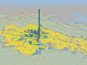
Richmond region settlement patterns, circa 2013.
In May about 300 people gathered at Virginia Commonwealth University’s Siegel Center to participate in a Reality Check visioning exercise for the Richmond region. Everyone crowded around tables and placed Lego boxes on maps to indicate where they thought 450,000 new people and 200,000 new jobs expected for the region ideally should be located should be located by 2035. Teams at 28 tables produced 28 different visions of the future.
Yesterday, ULI-Richmond unveiled the composite results of those 28 efforts. As the RVA Reality Check Results summarizes the results of the exercise: “Participants overwhelmingly chose to grow in a more dense pattern than currently exists. Every single group of participants built more densely, and some significantly more so. Further, most groups carefully avoided building on undeveloped land, showing a strong preference for preserving undeveloped land and using current infrastructure.” Virtually every group concentrated much of the new development in downtown Richmond and nodes like Innsbrook office park.
Seventy-five percent of the participants expressed a preference for preserving historic and natural resources, especially the James River; roughly 80% for expanding multimodal transportation options (i.e.mass transit); and 68% favored more mixed-use development.
By and large, I share those Smart Growth preferences. But it’s hard to know what to make of the findings. First of all, the participants were a self-selected group of real estate professionals, environmentalists, government officials and citizen activists. How representative are they of the community at large? Not very. For all practical purposes, Reality Check reflects the views of the civically engaged elite, not the general population.
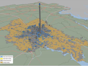
Composite vision for Richmond settlement patterns, 2035.
Secondly, the exercise largely ignored economic and financial constraints. Background data provided the participants gave some sense of the infrastructure costs incurred by different categories of development, but people seemed to take at best cursory notice. Missing from the exercise were (a) market supply and demand data, (b) the constraining effects of city and county zoning policies, and (c) information on density levels required to make mass transit economically justifiable.
I wouldn’t call Reality Check a meaningful guide to Richmond’s future. But it does encapsulate the preferences of the region’s civic elite — the people who drive transportation, land use and development decisions. It’s pretty clear that there is a major disjuncture between what the elite would like and what the City of Richmond and outlying counties are zoned to deliver.
— JAB

