
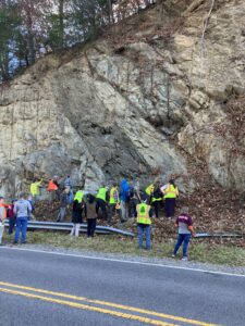
Mafic dike in wall of granite. Roadcut on VA Rt. 16 near Mouth of Wilson Baptist Church
by Dick Hall-Sizemore
This past weekend I went back in Virginia’s history. Waaaay back. Over a billion years back.
The occasion was the 2023 Virginia Geological Field Conference. This is an annual event staged by a group of leading geologists in the state. Attending were faculty members from several institutions, including one community college; geologists from the United States Geological Service; staff from several state agencies, such as the Department of Environmental Equality; college students, folks from the private sector; and one or two non-geologists (such as me) who nevertheless are keenly interested in the science.
We met in the Mt. Rogers area (the site of the conference rotates among Virginia’s five geographic regions). There we spent a day and a half traveling among sites that have been explored and mapped by USGS geologists over the past few years. We would go to a site, get a briefing from the lead USGS geologist and then go crawl over and around the rocks, with many using their geologist’s hammer to break off chunks for examination. As for me, I would stand in front of a wall of rock or hold a chunk in my hand and ask one of the USGS or other geologists, “Tell me what I am looking at.”
Most people (including me), when they think of Mt. Rogers at all, simply think of it as the highest peak in Virginia. But it is so much more than that. Mt. Rogers and two other nearby mountains are the remnants of ancient volcanoes. A glacier once covered much of the area. There was a huge lake that covered a significant portion of the area. (When I asked how big a lake, the USGS guy just spread his arms out wide.) The whole area is the leading edge of the Blue Ridge Thrust Plate. (That is the part of the state that was pushed up, back, over when the land mass that contained what is now Virginia slammed into Northern Africa during the formation of the supercontinent Pangea.) In the Mt. Rogers area, there are portions of the “basement rock” that was formed 1.3 billion years ago during the formation of the earlier supercontinent Rodinia. (I got a chunk of that.)
I bring all this up on a blog devoted to public affairs because an experience like this gives one a whole new perspective on the world. We argue passionately about events, but their importance and immediacy seem to fade in the face of so much quiet continuity. The rocks were here long before humans inhabited the Earth, and they will be here a long time after this generation of humans has passed. For example, these rocks have endured many changes in the climate. At the same time, however, they are not permanent. They erode, grain by grain, primarily from weathering. After all, the sediment from the mountains is what constitutes our beaches.
Another benefit of the conference for me was watching scientists work. The lead USGS geologist would present his findings (of which I understood about five percent) and others would challenge some of his conclusions or theories. He would then present the reasons why he thought his conclusions were more plausible than an alternative being presented. (The guidebook he created for the conference will likely be soon published as a USGS bulletin or paper.) In some cases, they would note that long-held explanations had been superseded. “We used to think “xyz”, but now, based on more recent evidence, we think “abc.” (For example, the likely time period of the Mt. Rogers glacier has been changed to a time earlier than once thought.) The technology that current geologists have is far superior to that available to their predecessors. Nevertheless, they are building on the findings of past geologists—refining and tweaking those earlier theories.
Furthermore, there are still lots of questions. Geologists often have explanations for what they are seeing in the rock but admit that is just their conclusion and may not account for all the evidence present. (Geology is unlike most other sciences. Often, there are unavoidable gaps in the evidence, eroded away. Also, a lot of evidence is deep underground, not easily available.) They often disagree. One presentation showed three different mappings by different geologists for the same fault system. And, finally, there were occasions for which they had no answers.
At the last stop on Sunday, we were examining an outcrop of mudstone (fine-grained sedimentary rock) and some rocks had lots of white spots on them (some said it looked like bird poop). Neither the retired state geologist, a retired geology professor, nor the lead USGS geologist knew what it was and all said so. (Somehow, it was reassuring to me that these experts don’t always have the answers.)
At the end of the conference, I realized what a relief it was to be, however briefly, in an atmosphere in which people were not arguing passionately about DEI, abortion, critical race theory, tax cuts, immigration, parents’ rights, etc. Instead, there was serious discussion and good-natured debate about rhyolites, mafic dikes, intrusions, faults, unconformities, amygdule (look it up), cameras, etc.
The one exception was a high school earth sciences teacher whom I sat next to in the van on Sunday. In response to my questions, he voiced the same complaints that often appear on this blog: students’ poor preparation, pressure to pass students, too few days to cover the material he needs to cover for the SOL, students’ attitudes and discipline problems, and lack of backing from administration.
Finally, I took this picture for the benefit of our resident historian of religion in Virginia, James Wyatt Whitehead:
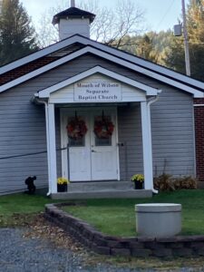
I also saw Missionary Baptist churches, but could not get a picture of one.

