
by Dick Hall-Sizemore
This year’s Virginia Geological Field Conference was held in Radford the weekend before Election Day. Like the one I attended last year in the Mt. Rogers area, it was an opportunity to go back in time as well as get a brief respite from the drumbeat of politics.
The tenor of this conference was different from last year’s, which focused on ancient rock formations and the forces that created them. There was a considerable amount of that kind of focus this year, as well. After all, these are geologists and that is what they do. However, the main focus was on the current effects of these geological forces and formations. The theme of the conference was “Rocks, Water, and People: Establishing Connections Between Geological Processes, Water and Mineral Resources, and Human Activity in the New River Valley of Virginia.”
The geology of the New River Valley is significantly different from that of the Mt. Rogers area. Mt. Rogers is part of the Blue Ridge physiographic province, dominated by granites and “basement rock.” The New River Valley is in the Valley and Ridge province, which encompasses the area west of the Blue Ridge to the West Virginia border, including a good part of Southwest Virginia.
The area that now constitutes the Valley and Ridge, along with most of the northeastern coast of the United States, began to form during the break-up (rifting) of the ancient supercontinent Rodinia about 800 million years ago. For about 500 million years, that tectonic plate drifted in ancient seas with much of it covered in fluctuating levels of water. As a result, some of the basement rock is still present, but the most prevalent geological formations are sedimentary—sandstones, shale, limestone, and dolomite. These are the formations that have shaped the interconnections among rocks, water, and people.
Karst
Karst is defined as “terrain created from the dissolution of soluble rocks, principally limestone and dolomite.” The most common examples of karst are sinkholes and underground caverns.
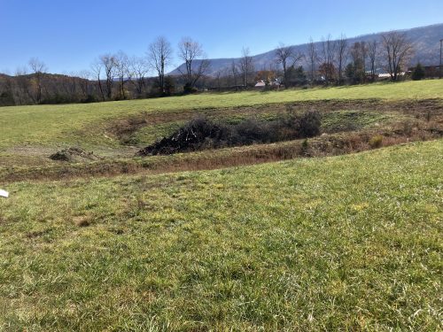
Giles County is underlain with karst. As of 2023, 74 miles of underground cave passages had been surveyed beneath the county. The longest and deepest is 22.5 miles long and 718 feet deep. New caves and new passages in known caves continue to be discovered. The town of Pearisburg, the county seat, is located on a “sinkhole plain.” An aerial image reveals at least 100 sinkholes within the town. There are underground streams. Sinking Creek disappears underground and re-emerges 2.5 miles downstream as a spring.
The Mountain Valley Pipeline crosses Giles County. Karst was a major consideration in planning and constructing the pipeline. A significant number of previously unidentified karst hazards were discovered during field-based studies, resulting in numerous additional route adjustments.
Hokie Stone
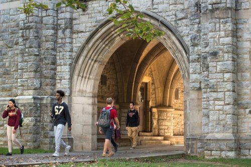
Those readers familiar with the Virginia Tech campus are doubtless familiar with the distinctive stone veneer facing of its main buildings. That stone is affectionately known as Hokie Stone. It is native dolostone (or “dolomotized limestone,” as one geologist called it) quarried in the Blacksburg area. Virginia Tech owns and operates the quarry currently used to produce Hokie Stone. Dolomite comes in muted shades of pink, red, gray, brown, and black, which can vary quarry to quarry and even at different levels in a single quarry.
There have been a number of dolostone quarries in the Blacksburg area, including on the Virginia Tech campus itself. The first building using the native stone was built near the turn of the 20th century, using stone from a quarry on the northwest edge of the campus. That quarry is now buried beneath the Architecture Building complex. The current quarry is located off campus adjacent to a residential area in Blacksburg.
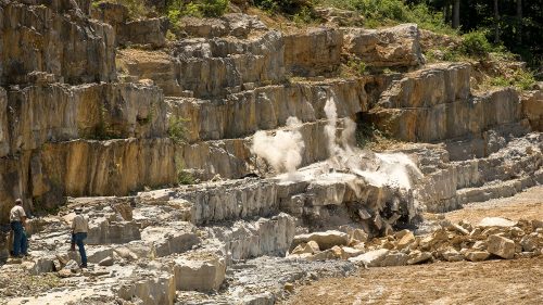
Virginia Tech personnel not only blast and cut stone blocks from the quarry walls, they cut and polish the stone on site to produce the seven-inch thick blocks that are used in construction projects on the campus. A large-diameter diamond saw and a wire impregnated with diamonds are used to cut the stone. The equipment with the diamond wire is programmed to run 24 hours a day. The facility is operated six days a week to keep up with the need for stone.
According to the Virginia Tech magazine, Tech’s quarry operations produce about 50 tons of Hokie Stone per week, or approximately 2,500 tons annually. To provide some perspective, one ton of stone will cover about 35 square feet of a building. Torgenson Hall, including a stone bridge that connects it to other areas of the campus, is composed of about 2,700 tons of Hokie Stone.
The quarry in Blacksburg provides about 80 percent of the stone needed in campus construction. In order to have variations in color, Tech purchases the remaining 20 percent it needs from a quarry operation in Montgomery County, but Tech quarry workers process the blocks into Hokie Stone.
The limestone was formed from sediments laid down in shallow ocean waters about 480 million years ago.
Iron and pigments
Some sandstone and siltstone deposits formed about 500 million years ago when what is now the Valley and Ridge province was covered by shallow oceans rich in iron oxides. Those iron oxides were the major source of iron for the Confederacy. After the war, they were the source of a thriving iron industry in Virginia during the latter part of the 19th century.
One of the sites was Hiwassee, in south-central Pulaski County. The story goes that, during the Battle of Cloyd’s Mountain, a Union soldier, whose family owned a foundry near Philadelphia, noticed a lot of iron ore in the area. After the war was over, he returned and, “Carpetbagger that he was,” bought up a large portion of that side of the New River and started an iron works.
In addition to iron ore deposits, the deeply weathered sandstone and siltstone overburden included iron oxide that could be used for pigments for a wide variety of products such as paint, varnishes, clothing, inks, and cosmetics. To produce the pigments, the rock material is successively reduced by grinding. As explained by the former owner of the Hoover Color Company, which had operations at Hiwassee, “A pigment is a fine and soluble powder. So, we’re trying to get our particles down to about one micron. A human hair is 100 microns. The pebble we made pea-sized. From the pea, we made a sand-sized piece and we take the sand and make our final pigment.”
After larger, much higher-grade iron ore deposits were discovered in the American West, demand for Virginia iron ore decreased significantly. The owners of the iron works at Hiwassee converted the operation to the American Pigment Company. The operation saw a series of owners culminating in the purchase of the mines and processing facility in 1973 by the family-owned Hoover Color Company, a New Jersey corporation that had been a customer of the former owner. In 2016, Hoover was acquired by Cathay Industries (now Oxerra Americas) when none of the youngest generation of Hoovers wanted to continue in the family business. (At the time, the company leadership was the fourth generation of Hoovers to lead it.) The new owner ceased operations in Hiwassee earlier this year.
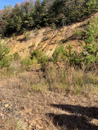
Pictured above is the one of the iron oxide pigment mines at Hiwassee. The mining operation at this site ceased in 2010. The Hoovers donated 250 acres that included this site to the state for the development of the Hoover Mountain Bike Area, which is a segment of the New River Trail State Park.
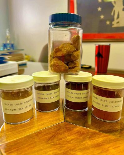
As is evident in the picture, the iron oxides in this area are yellows and browns, “earth tones.” Using pigments from these iron oxides, along with pigments and rock material purchased from other sites, the Hoover Color Company has produced pigments for some high-profile products. They were used to produce the brown shades in Walt Disney’s animated movie, Snow White and the Seven Dwarves. The pigment for the distinctive brown paint on UPS trucks was developed by Hoover, using the iron oxides from Virginia stone. From 1990-2014, Hoover produced the colors for all Crayola crayons.
One of the pleasures of the conference for neophyte amateurs (me) was the interaction among all those attending. There were academics (including the current president of the Geological Society of America), professional geologists from the state and the United State Geological Survey, representatives from the private sector, and students. For the most part, these were people who had known each other for a long time and were friends. However, that did not inhibit them from questioning and challenging each other’s conclusions or interpretations.
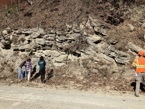
Furthermore, there was a sense of modesty present. One stop consisted of a long road cut comprised of complex geologic structures. The geologists taking the lead at this stop outlined the current interpretation of the structures, but pointed out questions that had been raised since the outcrops “are better exposed now due to recent flooding from Hurricane Helene.” They went on to say, “These observations raise structural and stratigraphic questions, and we look forward to the insights of field trip participants at this stop. We offer a few possible interpretations for consideration….”
As the gaggle of geologists proceeded along the road, inspecting the various structures up close and from a distance, sometimes using a rock hammer to get a sample for closer examination, one could hear talk of anticlines, synclines, anticlinorums, faults, folds, Shady Dolomite, and Rome Formation, among other terms. It was a graphic illustration that science, and our understanding of the natural world around us, is not static, but ever-evolving and that people of goodwill, although disagreeing with each other at times, can work collaboratively to advance our collective knowledge.
(Note on sources: Except where indicated otherwise, I relied heavily on two sources for this article. One was the guidebook put together by the organizers of the field conference. An article published by The Patriot/The Southwest Times provided a lot of the history of the Hoover Color Company: https://pcpatriot.com/hoover-color-closes-after-vivid-history/ )


Leave a Reply
You must be logged in to post a comment.