
by Jon Baliles
For some time now, the city has been engaged in an effort to update the city’s zoning ordinance which was written in 1976. Richmond has come a loooong way in that time in many ways and in other ways…not so much. The latest zoning effort, known as Code Refresh, has generated much discussion and debate about how to grow the city in the decades ahead. Richmond is landlocked and cannot annex any of the surrounding counties (which I’m sure they’re thankful for); nevertheless, in order for Richmond to grow, it needs to grow up (literally and figuratively) and it needs to spur growth and development vacant and undeveloped properties, of which there are plenty.
The Code Refresh effort has held numerous public sessions over the last year plus and the process has drawn much discussion and debate, sometimes intensely so. There is a school of thought that the city needs to maximize density on just about every single property no matter where it is, and there is a school at the other end of the spectrum that wants little to no change or rewriting the zoning code. As usual, the truth and the solution are usually found somewhere in the middle.
The second phase of the city’s public comment period on Code Refresh is coming to a close on March 1st (Sunday), so you have a chance to weigh in if you have not already done so. The city created a helpful, interactive map where you look at your neighborhood and see what changes are proposed and participate and add comments and register your support, concern or displeasure. The goal is to have City Council approve parts or all of Code Refresh sometime later this year, so this weekend might be your last chance before Council considers it.
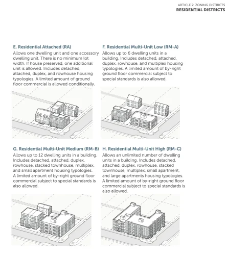
Stephen Versen, the Museum District Association Zoning Chairman, published an immensely helpful guide this week about the approaching deadline and how to register your opinion. He points to the city’s Code Refresh webpage and then, to learn what each category means, points to the “Draft Two Zoning Regulations.” He notes that Starting on Page 2-17 (or pdf page 28) you can find more detail on building height, density, number of units, etc., and to see what uses are allowed in those zones, you scroll down to Page 3-4 (or pdf page 128). You can look at your neighborhood or elsewhere and click on an area of interest or concern and register to leave your comments on the site, or you can email the Planning Department at [email protected].
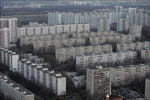
For the most part, zoning of existing buildings will not change much in the city, but there are some issues and conundrums that remain with the process. Most people would agree the city needs more density (that’s what cities are), and since we can’t grow outward as we did historically, the question becomes, density to what degree? The city needs more housing, but at what length do we go to encourage and incentivize it? Is the answer to cram as many residences on each parcel and build as high as we can? That’s what Soviet housing and neighborhoods looked like, which were beyond awful, devoid of any character, and life-sapping.
At the same time, we know the status quo is not tenable and the city must change and grow, but like all arguments with extremes on both sides, what does moving forward smartly look like? To get there, there are still have a lot of questions that need answers and clarity and buy in, which means the city has to be willing to listen and adapt, too. Kevin Vonck, the city’s planning director, said his office mapped out almost 77,000 parcels of land in the city in recent years and the more than three dozen zoning districts in the existing zoning ordinance make it hard to grow the city. The city has long relied on the Special Use Permit that allows uses that would otherwise violate the code, but it is a slow, cumbersome, and expensive process.
He told VPM News, “we’re trying to figure out, can we at least at first adjust the code to make the things that do exist, and a lot of the neighborhoods that Richmonders love, legal and conforming.”
Vonck said the city officials are being “thoughtful” and have their “eyes wide open” to the potential impacts of zoning changes.
Mayor Avula has said the process is thoughtful and deliberate and that the city is listening. He said at a press conference last fall, “our approach to this is we’ve got to use every tool that we can to increase housing production in our community,” and Code Refresh was one of those tools to meet the growing demand of housing and the people who are moving here. The city’s population has grown from 203,000 in 2010 to about 234,000 today. The Mayor added, “if we’re going to temper the real estate market, if we’re going to cool the real estate market, we do need to produce more housing.”
He also tried to put to rest that the outcome of Code refresh was preordained. “Let me reiterate that what we are doing right now in this community engagement process,” and added, “There is not a fixed plan about what zoning is going to look like as we go and have all of these community meetings, as we have different voices weigh in on the proposed zoning plan, we will make adjustments. And so absolutely, the outcome is not fixed. We really are sincere in our effort to hear from people. We will use this feedback to really be responsive to the things that we’re hearing from community members.”
There are easy ways to hit singles and score runs by looking at the low hanging fruit for adding housing and increasing density like conversions of office towers into housing. Just this week, there was a big celebration about work getting underway at a former Dominion office tower on Main Street that will be home to a 200-room hotel and 300 mixed-size apartments; and there have been many office-to-residential conversions downtown over the last decade plus and more than a few vacant lots downtown.
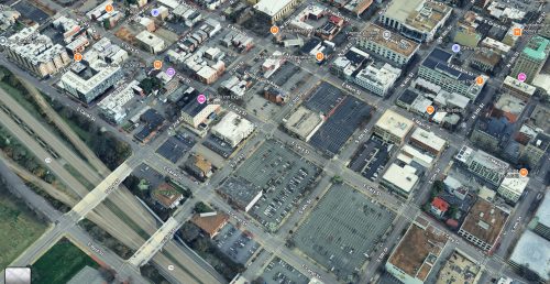
There are also projects that have already started to change streets and neighborhoods like the development of surface lots in places like Monroe Ward. This photo of Monroe Ward along the Downtown Expressway shows numerous, large parcels waiting for development; in the left-hand corner of the picture are infill apartment buildings that have all been constructed in the last decade or so on former surface lots or small buildings.
However, the most intense debate about density comes when you start talking about rezoning neighborhoods. Sarah Vogelsong at The Richmonder reported last year about the “duplex proposal” that appeared in the first version of Code Refresh. Initially, it was proposed that two units would be allowed on all residential parcels in the city by right; however, that was amended later to include a “preservation bonus.” Vogelsong explained:
Intended to discourage teardowns of existing structures, the bonus allows a property owner to construct a second unit by right only if they preserve the primary structure, and it limits the new unit’s placement to behind or within the current home. (In both cases, following a City Council decision, accessory dwellings are also allowed on nearly all residential parcels.)
“The kind of overall theme here was that people were worried about displacement in certain neighborhoods, people being pushed out, and also the architectural character of neighborhoods substantially changing with the removal of existing houses,” said René Biberstein of Code Studio, the consultancy the city has hired to help with the refresh. “So new standards were essentially established to incentivize preservation of existing houses while also allowing for some intensification.”
That decision was seen by some as an agreeable compromise and others as watering down the ability to maximize density everywhere. Advocates of duplexes and triplexes argue that allowing such development by right on all parcels will encourage more affordable development and reduce housing costs everywhere and not just in low-income areas. Opponents say allowing two, three or four units on a residential parcel will inevitably change the character of the neighborhood and not for the better, nor is it a guarantee that any such additional housing would be “affordable.”
Another area of contention has been over building heights. Maximum density advocates would like to see 13-story or more buildings along major transportation corridors like the Pulse line along Broad Street. One area in particular is along Broad Street between VCU and the Science Museum. That corridor has been designated as MX-13, which would allow mixed use development by right up to 13 stories tall (see the hideous apartment building next to the Lowe’s for reference). Residents of the Grace Street corridor south of Broad have steadfastly argued the agreement they made with the city during the Transit Oriented Development (TOD) rezoning a decade ago when establishing the Pulse line should hold and limit the height of buildings along that stretch.
That seems like a reasonable compromise, which is what this debate should be about and not taking anything and everything to the extreme. The north side of Broad Street does not back up to any neighborhoods, but the south side of the street does. The neighbors on Grace Street have said all along the city should go hog wild north of Broad, but limit the south side to somewhere between three and five stories, depending on who you ask. Not to mention, if the city is going to make deals like the one they did with Grace Street then later break them, how will that instill trust in City Hall to do anything or make even minor changes that can affect people’s daily quality of life?
There is another concern how Code Refresh is currently framed. In areas proposed for RM-A, RM-B, or RM-C zoning, it would allow ground-floor commercial activity in buildings in the middle of a street (in row houses or apartment buildings) by-right “subject to special standards” but with no parking requirements for a restaurant, convenience store, retail, or a soon-to-be burgeoning weed outlet once the state approves their Cheech & Chong legislation. Such establishments would be administratively approved with no neighborhood input.
If the goal is to make neighborhoods more walkable, then having corridors of commercial activity makes more sense than allowing it in apartment buildings or houses on every block. The RM-A, B, and C designations have been proposed in some most walkable neighborhoods in the city like Church Hill, Union Hill, and the Museum District, all of which have existing commercial corridors. It seems counterintuitive (or nefarious) to allow intensified commercial activity by right in some neighborhoods that are already dense and walkable with commercial corridors (or at least limit such uses own corners or corridors and not mid-block).
The most repeated refrain for changing the zoning code has been about providing more housing options for city residents and those that want to move here. We have heard for years that we need more housing, more affordable housing, etc., and that is beyond doubt. However, there has not been a huge movement or proven need to allow for commercial or retail development in the middle of residential streets. Even before Covid, the city had an excess of vacant commercial and retail space that has only intensified since 2020. It is slowly coming back, but that certainly doesn’t warrant opening the flood gates the way the RM-A, B, and C zoning designations are written.
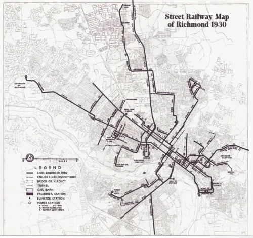
History instructs that higher intensity or trafficked uses such as stores and restaurants are in most neighborhoods generally located on corners or along more heavily trafficked (cars and pedestrians) corridors. If you look at the city’s old streetcar map, many people rode streetcars to and from work and the main corridors housed the markets and stores people would visit before walking home, and that is why those corridors have the commercial structures they do. Think of Robinson Street or Laurel Street in The Fan, Lafayette Street in the West End, Brookland Park Boulevard in Northside, or Venable Street in the East End.
Versen noted two other concerns in his take on the latest version of the plan that are worth a quick note. One would allow all churches in the city to be zoned MX-3 (mixed use, 3 stories); if a church was sold or moved its congregation, it could be replaced with almost any kind of structure or commercial activity three stories in height. He noted as “extreme examples” that a church could become a brewery or frat house, but his point is two fold: it “could allow for something strikingly different from its surroundings” and could “create a powerful financial incentive for that institution to sell and have the property converted to a different use.”
Change is good (and the only thing that is constant), but his concerns are valid; rather than a blanket exemption given that most churches are in neighborhoods and some sit on large parcels, it might be a more appropriate to find a different zoning designation for churches citywide and should warrant further discussion. (There have been numerous conversions of churches to residential and other uses, most notably in The Fan District; however, they were done using the existing structure.)
Versen also suggested that some context be added to the Code Refresh definition of “amenity space” that doesn’t allow the potential for out-of-scale development with new construction. As written, CodeRefresh would allow development to include rooftop decks and internal courtyards as “amenity space” which would give the building the appearance of more lot coverage. He has suggestedadding a “lot density contextual requirement, something like by-right lot coverage cannot exceed by 50% the lot coverage of neighboring properties. This would be similar to existing contextual requirements that make building setbacks align with neighboring properties and height restrictions that forbid more than a one-story difference on adjoining properties.” Requiring that amenity space to be on ground floor and visible from the street would help prevent some neighborhoods or parts of neighborhoods from morphing into looking like Scott’s Addition. What’s been built in that neighborhood fits in better with the less intensive and industrial uses that existed there for decades, but would not go over as well in a demolish-and-rebuild project in places like Northside or Westover Hills.
Richmond is a city of neighborhoods and always has been. They have changed over the years and will continue to do so in the years ahead. Sometimes they changed because population moved in (or out), sometimes because of federal redlining housing policies, in some cases industry relocated and opened up parcels; in too many cases the city tore down some dilapidated neighborhoods (and some were saved by residents), and we should not forget that, twice, the city and the state cut neighborhoods in half with interstate highways.
Now we have a chance to shape the city’s future and our ability to grow population-wise and economically. That chance depends on finding a path for growth that is smart and strategic, not extreme or noxious. It shouldn’t move at a snail’s pace, nor should it be move with a battalion of bulldozers and lighter fluid. If density and walkable neighborhoods are the goal, then there is less need to completely reinvent the wheel where those things already exist and focus more on creating those things where they don’t. Tweaks and movement are always helpful, while tsunamis and flooding are less so.
Some people see compromise as a four-letter word, but crafting and achieving compromise often signifies you can create a good plan with the actual ability and likelihood to get it implemented — everyone gives a little something, everyone gets a little something, and everyone is both a little bit happy and a little bummed out. Given Richmond’s history both past and present, the bigger the vision, the less likely it is to become a reality. Code Refresh has a chance to become a guiding document if the vision and plan can be implemented together and not forced fed. Add your voice to the discussion by Sunday and stick around for the continuing debate in the year ahead.
Jon Baliles is a former Richmond city councilman. This article has been republished with permission from his Substack blog RVA 5×5.
Leave a Reply
You must be logged in to post a comment.