
by Dick Hall-Sizemore
The redistricting map presented by Democrats is outrageous, embarrassing, and just plain outlandish. I can’t think of other words to describe it. It certainly violates the state constitution’s requirement that districts be compact. The traditional ideas of respecting communities of interest and jurisdictional boundary lines to the extent possible were thrown out the window.
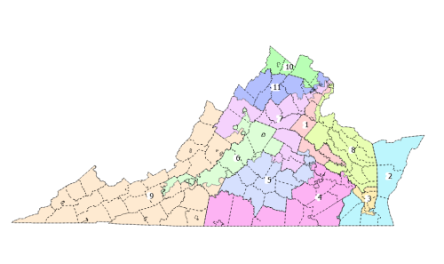
The most outrageous examples:
First District: From King William County, east of Richmond in the Middle Peninsula, the district snakes northward all the way to Alexandria. For most of its journey, it is only one county, part of one county, wide.
Fourth District—From Prince George and Surry Counties south of Petersburg, it goes southwest and then west all the way to Pittsylvania County.
Seventh District—From Powhatan County, just west of Richmond, this district goes north to Orange County, then splits. One branch continues west and includes parts of Rockingham and Augusta Counties in the Shenandoah Valley. The other branch heads northeast, picking up parts of several counties all the way to Arlington. Whoever represents this district will have constituents from the Richmond suburbs to the Shenandoah Valley to Northern Virginia.
Of the state’s 11 members of Congress, five would would have a portion of Fairfax County in their districts.
I could support the proposal to have a mid-census redistricting to tweak some districts to pick up a couple of Democrat seats as an answer to Trump’s manipulating the redistricting in Texas and other states to gain Republican seats. However, Virginia Democrats have gone too far.
Leave a Reply
You must be logged in to post a comment.