|
When
James Oglethorpe drew the layout in 1733 for a new
settlement in the pine wilderness of Georgia, he was intent mainly
upon organizing his band of colonists so he could
muster them to repel the Spanish. It could not possibly
have occurred to him that he was designing what one
day would come to be regarded as one of America's
urban gems.
He
laid out the city of Savannah in squares that he called
"wards." At the center of each ward was a
smaller square, which he left open, to function as a
military exercise ground for the settlers living around it.
The four corners of each ward contained a "tything,"
10 lots for housing. Serving Oglethorpe's early
18th-century notions of
equality, each lot was the same size. On the east
and west flanks of each square, he allotted larger
parcels he called "trustee lots,"
designated for public structures such as churches,
banks or government buildings.
Oglethorpe's
original plan called for six contiguous squares. As the city expanded, it replicated the squares
repeatedly, eventually creating
24 of them before abandoning the pattern for other
development forms. Some of the tythings have
been replaced by magnificent mansions, and a few
historic buildings have been lost to abominable, 60s-era
architecture. But
overall, the historic district remains remarkably well
preserved -- and is remarkably well adapted to the
modern era.
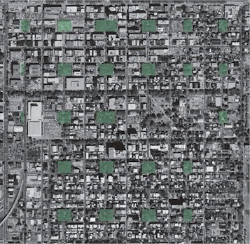
This
aerial view of Savannah highlights in green the
square
parks.
The grid street pattern is easy to discern. (Wikipedia)
I
visited historic Savannah last month on the way to
Disney World. The Bacon family was visiting
relatives on the outskirts of town, so we could
linger downtown no more than a few hours before hitting the
highway. I'd heard people say great things about the
city -- and seen snatches of it in the
movie, "Midnight in the Garden of Good and
Evil" -- but I'd never been stirred to go
there. I will confess that it was only upon the
urging of my wife, who absolutely must see
anything of remote historic, cultural or scenic
interest anywhere we go, that we detoured from our
hotel on the Interstate to take a look around.
Once we got there, I didn't want to leave.
Savannah
is a enchanted place -- far more so than
Orlando's Magical Kingdom, where we ultimately
ended up. We wandered along
the waterfront, where exhibitors were preparing for
a craft show, and then we hiked up Abercorn Street
to meet our cousins for brunch. We walked around a
bit more afterwards, and then we had to leave. So, when I write about Savannah, I do so from a
position of the most casual acquaintance. To say
that my
knowledge of the city "skims the surface"
would exaggerate the depth of my familiarity. But
even a cursory glance was sufficient to take in
lessons about functional urban design that would apply here in Virginia.
Savannah
appears to be a profoundly livable place. The people
who live in the historic district certainly believe so, for many have moved there from all
around the country. I spoke to one fellow, about my
age, who was standing outside and watering the
plants in clay pots along the side of his house. He
had lived in Lexington, Ky., and Charleston, S.C.,
and visited many other cities, and Savannah was the
one he fell in love with. It was not the munificence of the housing
that captured him -- most of the dwellings are modest
in size and the exteriors are spare.
It was the feel of the place that drew him, for in
Savannah, the whole is truly greater than the sum of
its parts.
Although
historic Savannah consists mainly of single-family
houses, development is compact. It's
not the square footage of the houses that makes it
so: It's the frugality in the use of space between
the houses. There are no setbacks. Because most houses abut
up to the sidewalks, there is little in the way
of front yards or side yards. From my
hasty observation, it appeared that some houses had
walled-in patios and gardens, but they were tiny. In sum, Savannah
economizes on private lots in order to lavish space upon its
public areas.
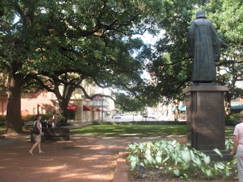
One
of Savannah's squares, on Abercorn Street. Each of
the city's 24 squares has its own distinctive
character, but each is integral to the surrounding,
mixed-use cityscape. Note the commercial buildings
in the background.
There
is a significant advantage to compact development:
It shortens the destination between any two
addresses. Shorter distances make a wider
array of activities accessible by foot, which
sometimes eliminates the necessity for using the automobile,
and they put most
residents within reach of the city's bus lines. Even when
driving is a necessity, compact development is a
plus: Reducing the distance between destinations cuts down on Vehicle Miles Driven.
It
is noteworthy that historic Savannah, though
compact, was not "congested." Admittedly,
we were visiting on a Saturday morning. But in my
observation of suburban Henrico County, Va.,
Saturday mornings are peak "errand
running" time and the main retail corridors
generate almost as much congestion as during rush
hour.
The
movement of automobiles through historic Savannah
was aided by a grid street system that provided many
alternative paths between any two destinations.
That's a marked contrast to the conventional
two-tiered system of "suburban" subdivision
streets, which serve no one but the residents of the
subdivisions, and connector roads. A majority of lane-miles
in the typical suburban
community functions as
private roadways, carrying ludicrously low levels
of traffic. As a result, traffic funnels into a limited
number of connectors and arterials, where
gridlock occurs.
In historic Savannah, as with most
cities laid out in grids, all streets
contribute to mobility. Thus, in a seeming irony,
the higher population density of the old city
equates to less
congestion.
Not
all streets are created equal, of course. As you can see
from the aerial photograph above, the edges of the
wards are thoroughfares, often lined
with businesses, which carry higher traffic loads.
Liberty Street, for instance, is a handsome,
tree-lined boulevard comparable to Monument Ave. in
Richmond. Running parallel to the main thoroughfares are lesser
corridors that intersect with the square parks. (The
squares function like traffic "circles,"
with one-way traffic circulating around the perimeter.)
Interconnecting the larger streets is a skein of local streets that provides
access to
individual city blocks.
I
imagine that parking can be a problem, as it is in
most neighborhoods with compact development. There is a
abundant curbside parking, but apparently not
abundant enough -- it is metered in places,
indicating a need to ration space in high-demand
locations. What struck me, though, was the
cleverness with which parking lots have been
integrated into the scheme of things without
creating large vacant spaces that have so shredded
the urban fabric in other cities.
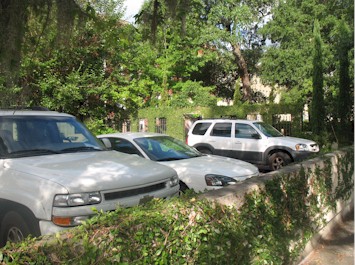
Savannah
parking lot tucked away behind garden-like walls.
As we
were strolling along, I stopped to snap the photo
above. What intrigued
me was how the lot was woven into the urban
fabric. The walls created visual interest for
passers by. The far-side wall, standing as high as the
side of a one-story
building, was bedecked with ironwork and
vines. Shade from the trees along the perimeter
softened the harshness of bare asphalt.
Those
who guided the evolution of the urban form after
Oglethorpe truly understood the importance of
maintaining what we nowadays call the
"pedestrian friendly streetscape." A
streetscape requires far more than brick sidewalks,
fancy streetlights and intersection pavers. The
pedestrian space is defined by the elements all
around the sidewalk, including the facade of houses
and storefronts on one side, and a psychological
barrier of mature trees and garden plantings on the
street side.
Savannah
offers visual delights at every turn. For the most
part, the city has preserved its historic
|
|
architecture,
with its richness of detail. Lapses into
'60s-era architecture do inspire occasional
gasps of dismay, however. One of the worst
offenders, ironically enough, is the Savannah
College of Art and Design, seen to the left,
which
|
has
played a leading role in historic preservation. With
its blank visage, this building creates a dead zone
in the streetscape.
|
|
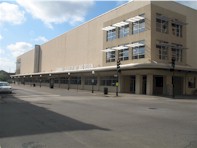
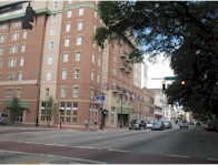
Fortunately,
some newer buildings have paid homage to the
style and scale of the historical structures.
The Holiday Inn hotel shown to the left may not replicate all
the features of historical buildings, but it
does maintain visual continuity |
with the
rest of
the district through its flags, ornamental trees,
balconies, brick facade and stonework around the
windows.
Savannah
is best known for its famous squares, which now
number 21. Each these oases of greenery is
distinctive in its own way: typically named for some
historic personage such as Oglethorpe, George
Washington or Count Casimir Pulaski, or some battle
of import to the early United States. Many squares
are arrayed around a statue or some other monument,
and every one offers places to sit amid carefully
tended gardens. Adding to atmosphere, many squares
are rimmed by architecturally significant mansions
or public buildings.
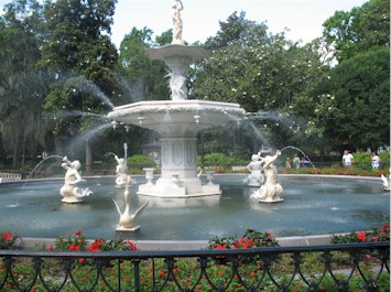
The
fountain at Forsyth Park.
There
is a reason that millions of tourists have visited
Savannah to stroll through its streets. The historic
district is visually appealing. The parks are
postcard picture perfect. The fountain in Forsyth
Park (depicted above) is as beautiful as any I've
seen anywhere in the United States, and comparable
to Europe's best. But parks alone cannot carry an
entire city. The streetscapes are crucial. And so
are the out-of-the-way nooks and crannies, so common
among old cities, that travelers happen upon almost
by accident.
Some
of Savanna's more interesting vignettes can be found
in the most mundane places, like along the
riverfront where the terrain rises some 40 feet from
the river to the top of the bluffs. The vista
depicted below won't make its way into anyone's
coffee table book, but I include it as an example of
the fascinating glimpses that greet visitors at
every turn.
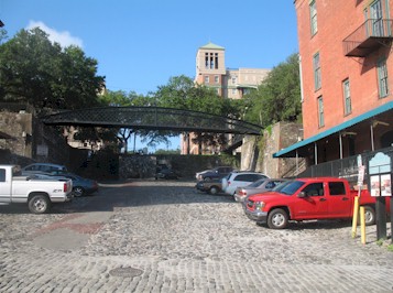
Cobblestone
street providing access to River Street.
This
cobblestone street rises from the river walk to Bay
Street above. I found the masonry to be distinctive,
as well as the steel pedestrian bridge overhead.
It's hard to distinguish in this photo, but there
are steps where pedestrians can climb to the street
level above. As evidenced by the cars and trucks, this odd
little scrap of urban space also serves as a place
to park.
It
takes more than scenery, of course, to make a city
an exciting place to live and visit. People
must be part of the landscape. And the way to make
people part of the landscape is to create an
environment that gets them out of their houses and
out of their cars. There are two aspects to this
urban-design challenge. One, discussed above, is to create
hospitable streetscapes. The other is to encourage
mixed uses.
Instead
of segregating land uses -- houses here, offices
there, and stores way over there -- historic
Savannah displays a finely grained mix of
activities. A
good illustration can be found down along River
Street, which is lined by multistory buildings on
the land side, and pocket parks and public parking
on the riverside.
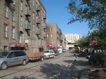
Savanna's
River Street. Note the restaurants and shops on the
ground level and the apartments above. The obtrusive
and inappropriate white building at the end of the
street is a hotel.
This
would not be the place to live if you're married
with kids, or if boisterous voices outside keep you
up at night. The ground floors of the old buildings
are lined with restaurants and shops, which, I
suspect, keep the place humming well into the
evening. When I took this early-morning photo,
things had settled down. Vendors were setting up
their craft booths along the river in preparation
for a festival that was to begin at 10 a.m.
Perhaps
the most intriguing aspect of Savannah is the least
visible to the naked eye -- at least from the ground
level. But you can see what I mean when you view the
aerial photo at the top of this column.
By
way of explanation, a bit of context.
While many people agree on the characteristics that
Virginia's cities should share -- compact
development, mixed uses, pedestrian-friendly
streetscapes and the like -- no one has figured out
how to expand the urban fabric of the street grid into the
free-form suburbs or countryside. How do you build,
or redevelop, just a few city blocks of development
at a time, adding them incrementally as the
community grows? In a related question, how does a
city grow organically in such a way as to preserve a
"balance" of jobs, housing and amenities
at the neighborhood level?
Oglethorpe
stumbled across a fascinating solution: Grow in
squares or other replicatable cells, in which
neighborhood balance is designed into the structure.
Each of Oglethorpe's squares contained not only a
park at the center but 40 residences and space for
stores, office or amenities such as schools,
churches, post offices or clinics. Another beauty of
Oglethorpe's geometry is that the streets of a new
unit can plug directly into the streets of its
neighbor. Connectivity comes built in. Who needs
transportation impact fees when the
"subdivision" roads and the
"connector" roads are one in the same?
Oglethorpe
had the advantage, of course, of drawing his plan
upon a blank sheet of paper -- and imposing his
vision upon a blank piece of land. We rarely that
luxury in Virginia today, where we have to work
around existing roads and development as well as
environmentally sensitive terrain such as steep
slopes and wetlands. Even the city of Savannah, for
one reason or another, found reasons to cease
replicating Oglethorpe's squares.
Regardless,
Savannah is a delightful place to visit, and I
recommend it highly to Virginians seeking insight
into what it takes to build prosperous, livable and
sustainable communities.
--
July 7, 2008
|