
by James A. Bacon
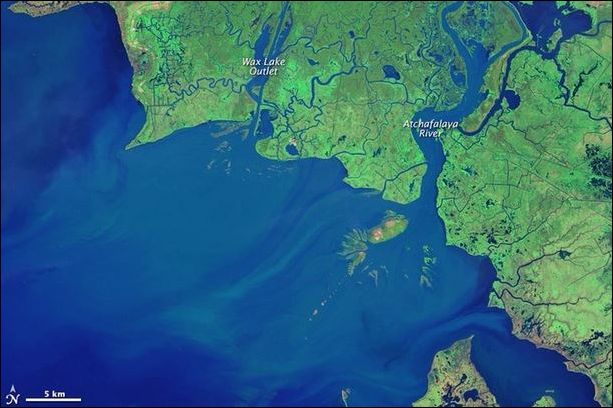
Atchafalaya delta, 1984
Louisiana’s coastline is shrinking. Humanity’s impact on the state’s massive but fragile wetlands — levees accelerating Mississippi River water flows, the criss-crossing of marshes with canals — has aggravated the natural phenomena of subsidence and sea-level rise to inundate some 1,900 square miles of coast land over eight decades. It’s an object lesson for Virginia, much of whose low-lying Tidewater region also could end up waterlogged as sea levels rise. We’ve seen the maps — I’ve published some on this blog. A hundred years from now, there could be little left of Norfolk and Virginia Beach in a storm surge but a bunch of islands.
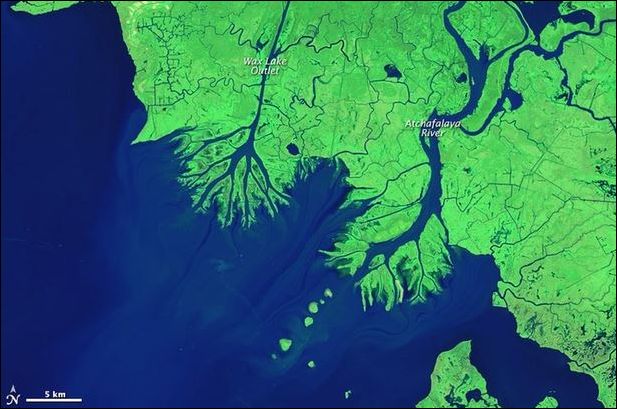
Atchafalaya delta, 2014
But, wait, the process of shrinking land mass is not inevitable. Portions of the Louisiana coast are expanding. That’s exactly what you’d expect to find in the Mississippi River delta as the nation’s mightiest river deposits massive volumes of silt and sediment into the Gulf of Mexico. An article in Atlantic CityLab shows satellite photos of the Atchafalaya River, which empties west of the Mississippi, in 1984 and 2014. This delta complex is growing at the rate of one square mile per year.
Writes John Metcalfe: “Scientists are quite interested in studying these processes, as they believe they might help counter today’s leading cause of coastal deterioration: rising sea levels.”
There is a widely held assumption that Virginia could lose hundreds of square miles of wetlands as local subsidence and rising global sea levels conspire to flood the Tidewater marshlands. But is inundation inevitable? The James, Potomac, Rappahannock, Susquehanna and other tributaries dump large volumes of sediment into the Chesapeake Bay — so much so that the silt clouds the waters, blocks sunlight and disrupts the bay ecology. But eventually the sediment settles to the bottom, contributing to the build-up of mud and muck.
It would be interesting to know: Which process is occurring more rapidly in the Chesapeake Bay — sea level rise or sedimentation? A related question: How is the sediment distributed? Accumulation of silt in the middle of the Bay just makes a shallower bay. But accumulation in the marshlands might support the creation of new land mass that we see in the Atchafalaya delta.
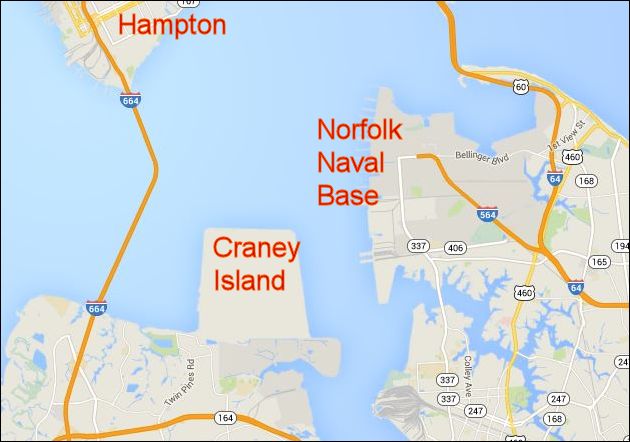 Dredging the sediment build-up in Virginia’s shipping channels costs tens of millions of dollars a year. Much of the dredge material has been directed to Craney Island, a man-made land mass that has transformed the coastline of Hampton Roads. We have a lot of raw material to work with.
Last summer, Governor Terry McAuliffe appointed a Climate Change and Resiliency Update Commission to prepare Virginia’s coastal communities for the impact of climate change. It strikes me that the sedimentation issue is ill understood and little discussed. How likely are Virginia marshlands likely to survive incremental sea-level rise as the deposition of silt raises the bay bed? To what extent can Virginia productively re-route sediment from channel dredging to build up the most vulnerable sections of the coastline?
There is a strong bias among those who fret about Global Warming toward solutions that entail re-engineering the nation’s energy economy in order to reduce the carbon dioxide emissions implicated in rising temperatures. Any changes we make in Virginia will have an infinitesimal impact on global temperatures, even if, as widely asserted, CO2 emissions are driving them higher. To survive global warming and rising sea levels, we must make our communities more resilient. That’s where our actions can make a difference.
The Governor’s commission is scheduled to submit its recommendations by June 30 this year. Let us hope that it incorporates the insights scientists are gleaning from Louisiana’s Atchafalaya delta.

