

Jamestown archaeological dig site. Photo credit: Daily Press
How does the state put a dollar value on historic, cultural and environmental assets threatened by eminent domain?
by James A. Bacon
In its high-stakes effort to win regulatory approval to build a 500 kV electric transmission line to the Virginia Peninsula, Dominion Virginia Power proposed in December to spend $85 million to mitigate the project’s impact on historical and environmental resources. That’s over and above the estimated $155 million cost to build the 7.7-mile line, which Dominion says is critical to maintain a reliable electric supply to nearly 500,000 residents from Williamsburg to Hampton.
Measures in the draft Memorandum of Agreement submitted to the U.S. Army Corps of Engineers would do nothing to alter the visual intrusion of the 17 towers crossing the James River near Jamestown. But it would allocate $52.7 million to underwrite archaeological work and other improvements in and around Jamestown Island, $15.6 million for water quality improvements, $12.5 million for landscape and battlefield conservation, and $4.2 million to acquire wetlands, restore shorelines and preserve historical resources nearby.
Dominion’s proposal is being circulated for feedback, and there is no guarantee that it will be accepted by the Army Corps, which is charged with considering the adverse impact of the project on wetlands and historic assets. In the view of some conservationists, nothing can make up for the cluttering of view sheds in and around Jamestown, one of the most important historical sites in American history.
Whatever the Army Corps decides, the MOA still represents a watershed in Virginia regulation. It would be one of the largest sums, perhaps the largest sum, ever proposed to offset the impact of a Virginia utility project on environmental, historic or cultural resources.
“We’ve not conducted an exhaustive file search, but [I] suspect that few final mitigation proposals to resolve adverse effects to historic resources associated with a Corps permit have exceeded a total cost of $85 million,” says Mark W. Haviland, chief of public affairs for the Army Corp’s Norfolk office.
Few spots resonate in the Virginia psyche like Jamestown does, but the state is chockablock with historical sites, cultural sites, landscapes, wildlife habitats and view sheds that many would like to preserve from development. As Bacon’s Rebellion documented recently (see “Clash of Competing Values“), these intangible resources have become so ubiquitous that it is increasingly difficult for energy companies to build gas pipelines or electric transmission lines without crossing multiple assets.
Decades ago, routing pipelines and transmission lines wasn’t the complex task that it is today. It was a relatively straightforward exercise to calculate the fair-market value of farmland, timberland and houses to compensate landowners for lost economic value. But the determinants of economic value for land have evolved. Increasingly, Virginians in rural areas purchase property for the views they offer or the natural habitat they conserve, not for their ability to extract income. Moreover, various public and private entities are identifying habitats and view sheds as worth protecting — historical sites and districts; federal, state and local parks; scenic highways and scenic rivers; private conservation easements and public conservation zones; and wetlands, wildlife habitat and more.
Can a price tag be put on an acre of habitat for the rare Cow Knob Salamander? How much is it worth to preserve the view from James Madison’s library window at Montpelier? What is the value of an obscure Civil War battlefield such as the indecisive 1864 cavalry clash at Samaria Church in Charles City County?
Much of the conflict between utilities and conservationists stems from regulators’ inability to value intangible assets that loom large in nearly every project, thus making it impractical for utilities to pay meaningful compensation. Dominion’s proposal is significant because it attempts to offset the adverse visual impact on Jamestown-area historical resources by funding the creation of non-visual benefits.
Both utility executives and their foes acknowledge the trade-offs between economic growth, jobs and profits on the one hand and hard-to-value historical, cultural and environmental assets. The great public policy question is what weight should be given to one and what weight to the other.
For years Virginia was a “a manufacturing powerhouse,” says Margaret Fowler, co-founder of the Save the James Alliance and one of the more outspoken foes of the Surry-Skiffes Creek transmission line project. “We were undeveloped, we needed power, we needed factories. Industrialization happened. At some point … we became sensitive to what we were losing — air quality, water quality, visual beauty. Has the pendulum swung too far? I don’t think so. But I understand the dilemma.”
Cultural attachment
In the current regulatory regime, utilities plot paths for their pipelines and transmission lines with the goal of creating the least disruption to landowners –within the utilities’ capital budgets. If a landowner refuses to grant an easement, the utility can condemn the land on the grounds that there is a public purpose for the project. There are well-established rules for determining the fair market value of the land taken from the property owners. But foes of big projects argue that fair market value cannot compensate landowners who have a long-standing “cultural attachment” to a property.
Cultural attachment is the “cumulative effect over time of a collection of traditions, attitudes, practices, and stories that ties a person to the land, to physical place, and kinship patterns,” wrote a group of environmental and landowners groups in a filing with the Federal Energy Regulatory Commission in opposition to the Atlantic Coast Pipeline.
Such attachment to the land is particularly widespread in rural areas where property has passed through the same family for generations. These are communities where everyone knows everyone else, where neighbors often are related to one another, where there are complex patterns of inter-dependence and mutual assistance. Inhabitants of such communities place a higher value on their property than would outsiders who are not embedded in the web of relationships and sentiment. Thus, the argument goes, the fair market value of the land, as established by sales of comparable properties, reflects the value others would place on a house or farm, not the value of landowners whose families have been entwined with it for generations.
James Kibler, senior vice president for external affairs for Atlanta-based AGL Resources, a partner in the proposed Atlantic Coast Pipeline, says he understands sentimental ties to the land. Born in mountainous Craig County near Roanoke, he says, “I have a strong cultural attachment to the Blue Ridge and Appalachians. I still get a lump in my throat when I come back home.”
To Kibler the question is, what is the greater good? The rights of landowners need to be acknowledged, he says. “But how are they so unique and so special as to outweigh the significant benefits” of a project like the Atlantic Coast Pipeline? “Is the greater good served when a very small percentage of the public can stop a project because of esoteric issues not everyone would agree with?”
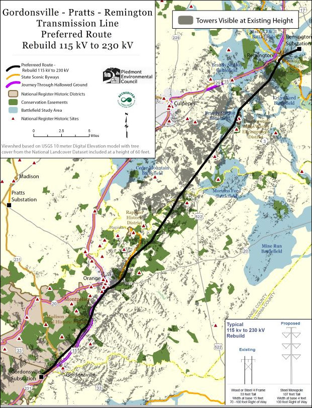
Gray areas show where Dominion Virginia Power’s existing 115 kV line between Gordonsville and Remington are visible. Map credit: Piedmont Environmental Council. (Click for more legible image.)
View sheds
Preservationists also attack big infrastructure projects — highways, pipelines and especially electric transmission lines — that disrupt landscapes. The desire to conserve view sheds is particularly prevalent in parts of the states such as western Virginia, with its spectacular mountain views, and the northern Piedmont, where affluent owners of vineyards and horse farms pay a premium to enjoy bucolic farming landscapes.
In the northern Piedmont, Dominion proposes to upgrade an existing 115 kV power line paralleling the scenic Rt. 15 corridor between Gordonsville and Remington. Although Dominion will use existing right of way, which transmission line foes commonly urge utilities to do, the proposed line will be roughly 50 feet taller and far more visible. Using off-the-shelf software, the PEC has mapped the impact of the existing line and the proposed line on the viewshed of the Route 15 corridor. The difference is dramatic, as can be seen by comparing the maps immediately above and below.
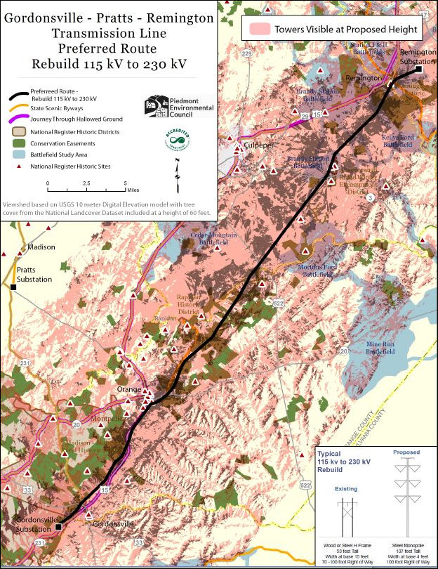
Beige areas show where the Dominion transmission line would be visible if upgraded to a 230kV line, according to PEC mapping software. (Click for larger image)
The Rt. 15 corridor’s scenic byway designation has no legal force, other than banning billboards, but it affirms the consensus of the communities along the road that they want to preserve the landscape. Counties along the route enact comprehensive plans to provide zoning protection, and citizens place conservation easements on their property.
The idea that “coherent visual landscapes” are worth protecting go back a century or more to the movement to set aside lands in the national parks, says Chris Miller, president of the Piedmont Environmental Council (PEC), which defends the scenic integrity of Virginia’s northern Piedmont. The preservation of view sheds can be seen in the designation of state parks, national scenic areas, and national heritage areas, as well as the recognition bestowed upon scenic rivers and scenic byways.
There are many other view sheds in Virginia that Miller would like to preserve. Take one of Virginia’s treasures, Monticello, for example. The first step was to purchase the building and keep it from falling in on itself. Then came the acquisition of Thomas Jefferson’s properties, some 6,000 acres of land. But more can be done. “This is a world heritage site, a national landmark and an anchor to our identity,” he says. One of the reasons Jefferson built his house upon a mountaintop was to enjoy the expansive view. That view, he says, “is what we’re trying to protect.”
Another example is the Madison-Barbour National Historic District around Montpelier. The goal shouldn’t be limited to preserving the home of James Madison, he says. “You want to protect the view from Montpelier. This is the view that inspired Madison as he looked out the window when he was writing about the Constitution.”
Scenic Virginia, a private, non-profit organization dedicated to the preservation of scenic beauty, argues that view sheds have economic value. In a public policy statement on utility corridors, contends that sightseeing is the most popular recreational activity in the United States. “Virginia’s scenic resources are arguably the major tourist attraction in the state, an thus make a significant contribution to our economy.”
Margaret Fowler with the Save the James Alliance takes the economic-development argument a step further for urban areas. Citing the work of Urban Land Institute fellow Ed McMahon, she argues that scenic resources are critical to creating a “sense of place” that people value, that communities possessing this magical quality are particularly attractive to the kinds of smart, educated people that corporations like to hire, and that corporate investment follows people to these places.
“Electricity is important, but so are views and national historic resources,” Miller says. “The cost of electricity is only one value. There has to be a balancing with public values. All we’re asking for is a robust process where the agencies given the responsibility of protecting the resources actually do.”
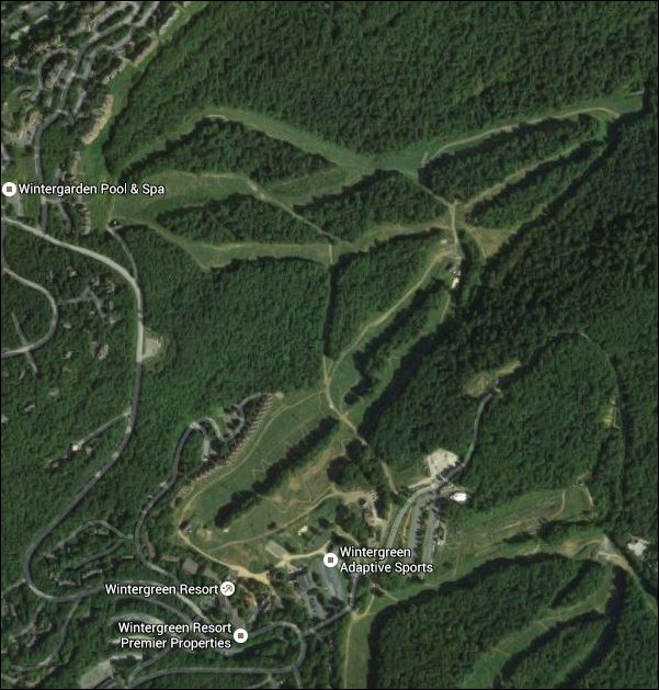
Aerial view of Wintergreen, showing ski slopes. (Cilck for larger image.)
However, Kibler, the AGL Resources executive, responds that these values are vague and subjective. “The Virginia Supreme Court has ruled that loss of view is not a compensable damage,” he says. “You can’t put a dollar figure on it. It’s too subjective.” For example, he says, residents of the Wintergreen resort get exercised about the “scar on the land” created by a 125-foot pipeline right of way that will be cleared of trees and planted with meadow grasses. Visually, what’s the visual difference between a pipeline right of way and Wintergreen’s ski slopes?
It is important to look at the larger context, Kibler adds. The pipeline right of way will consume 5,500 acres of land end to end. But compare that to the impact of wind farms or solar facilities capable of producing a comparable amount of electricity. Wind farms would require more than 70 times the amount of land, solar 300 times, he says, citing the Energy Sure website. Moreover, the pipeline will be buried “underground and invisible” while renewable energy sources would be above ground and visually intrusive. (The Federal Aviation Administration recently stated that ridge-line wind turbines in a proposed Botetourt County wind farm could pose a threat to aviation!)
Why, Kibler asks, aren’t environmental and conservation groups mobilizing to shut down wind and solar?
What to do?
Is the inherent tension between big energy and the preservation community destined to create win-lose scenarios, or is it possible to create optimal outcomes in which both sides get much, though not all, of what they want?
One idea is to document as many valuable places as possible and put them on maps so that when utilities begin planning routes, they can identify obstacles before they get committed to a particular route.
Scenic Virginia supports the creation of a scenic registry, similar to a landmarks registry, that identifies places that people regard as special. The hope, says Executive Director Leighton Powell, would be to push development away from these resources. “People want to be in beautiful places. … These areas have a lot of value — economic value, emotional value, health value.”
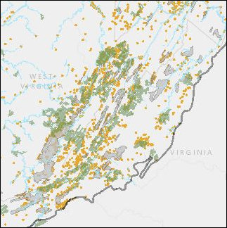
Nature Conservancy map shows priority forest cores (green), priority caves (gray), active cover in rivers (blue), and critical habitats (orange) in western Virginia and eastern West Virginia.
A parallel initiative, launched by the Nature Conservancy, is building an inventory of irreplaceable biological resources. “We’d like anyone planning a project to have access to the location of irreplaceable resources,” says Judy Dunscomb, senior conservation scientist with the conservancy. “In the Central Appalachian region, we’ve identified large patches of intact forest, caves and karst resources, and rivers where the forest alongside the river is intact, and globally rare species. We’ve mapped those out and made them available to anyone.”
Her long-term vision is to create a central statewide clearinghouse — a one-stop geographic information shopping, so to speak — where a project developer could find all environmental, historical and cultural resources. The database would have no regulatory weight, says Dunscombe, but it potentially could help utilities side-step a lot of conflicts.
Sometimes conflicts are unavoidable. In a concept analogous to a proffer in which a developer promises to upgrade roads or build a school to help offset the fiscal impact of a real estate development, Dominion is proposing to spend $85 million on projects to offset the negative impact of the Surry-Skiffes Creek line. Just as there is a rational nexus between the proffers and the development, Dominion’s plan posits a nexus between its mitigations and the historical resource — America’s first permanent English-speaking settlement and the land and waters around it — that would be harmed.
States a document that Dominion submitted to the Army Corps of Engineers:
The MOA defines a series of mitigation initiatives that while not able to further avoid or minimize adverse effects, will in our opinion, strengthen the general public and visitor’s understanding of an experience at significant places within and related to this landscape through enhanced heritage tourism opportunities including development of additional interpretive and orientation facilities. Proposed mitigation also seeks to ensure future permanent preservation of existing above-ground cultural landscape features, such as natural resources and systems, vegetation, landform and topography, land uses, circulation, buildings and structures, Native American settlements, views, and small-scale features through land acquisition, and acquisition of historic preservation and open space easements.
Critics of the Surry-Skiffes line undoubtedly will find fault with the proposal, but at least it provides an alternative to a yes-no decision by the Army Corps of Engineers.
In the meantime, preservationists are trying to tilt the regulatory playing field in their favor. Miller wants to make sure the “scenic” designation means something more than a signal to counties to put protections into their comprehensive plans. He’d like to see the Virginia Outdoor Federation, the state agency that manages conservation easements, take a more forceful role in State Corporation Commission deliberations over electric lines. (The SCC does not regulate gas pipelines.) “Scenic values haven’t been part of the [SCC] process,” Miller says. “It ought to be.”
“We value private property but we also value public goods,” he says. “Both are strong values. Working through those tensions is what democracy and our governing process are all about.”

