
Virginia development in 50 years: sprawl scenario
I’m a map geek because maps help us visualize information that is difficult to explain in words. In few fields of endeavor is spatial visualization more important than understanding human settlement patterns. That’s why I’m psyched that Luke Juday, an urban planning graduate student at the University of Virginia, has launched a blog, “Mapping the Commonwealth.”
If the quality of his first three posts is indicative of his future work, I’ll be a regular visitor. Check these out:
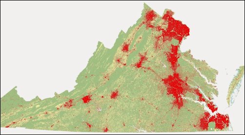
In “Projecting Development,” Juday shows what Virginia will look like in 50 years if it grows by the same population and at the same low densities as in the past 50 years. He doesn’t think this is a likely scenario — but it’s a precautionary tale of what could await the Commonwealth if we don’t mend our ways. The red in the map above represents developed area — roads, buildings, parking lots, etc.
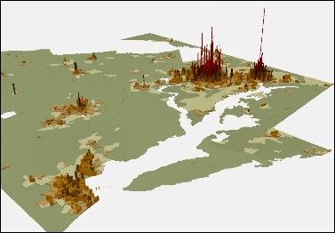 In “Visualizing Density in Three Dimensions,” he provides a 3-D look at density. This map highlights the a dramatic differences between Washington-Baltimore and the urbanized areas of downstate Virginia.
In another exercise, “Understanding Density and Urban Form,” Juday asks an interesting question: If all Virginians lived in settlement patterns of a particular density, how much space would they consume? He finds that if all 8.3 million lived at the density Richmond’s Fan district (grid streets, mostly single-family houses with very small yards) we would take up a space the size of Chesterfield County. If we lived as people in low-density, outer-ring suburbs do, development would consume one-fifth the land mass of the state.
Nobody’s advocating that any particular density is the “right” density — people should be free to live in the kinds of communities they choose, as long as they pay their location-variable costs — but it highlights the challenge of providing transportation, water, sewer, public safety and other public amenities over in low-density settings versus higher-density settings.
— JAB

