|
Albemarle
Place:
Can
a Giant New Development be Part of
Charlottesville's U.S. 29 Traffic Solution?
By
Bob Burke
CHARLOTTESVILLE
- Whoever picked this burg as the nations best
place to live probably didnt drive on U.S. 29.
The
city has plenty of college-town charm, and
surrounding Albemarle County showcases
Virginias beautiful piedmont. But north of the
city, the eight-laned U.S. 29 runs like a scar
across the landscape. A jumble of banks,
restaurants, gas stations, old and new shopping
centers are so poorly stitched together that you
cant get from one to the next without first
getting back onto U.S. 29 and clogging the traffic
there.
This
stretch of U.S. 29, which carries about 57,000
vehicles a day at the Charlottesville city limits,
is among the worst thoroughfares in Virginia. Yet
thats exactly where Albemarle County planners
have OKd plans for a whopping 1.9 million
square feet of new development, including 780
residential units, a 150-room hotel, big retailers
and a 14-screen cinema.
By
traditional planning logic, the Albemarle Place
project is in the worst possible location: The
trips generated by thousands of additional
residents and workers should turn U.S. 29 into a
poster child for gridlock. But the Albemarle
planners know what theyre doing. In fact, the
rest of Virginia should watch this development
closely because it may offer a way to harness
economic growth into a mechanism for transforming
the disconnected, traffic-plagued development of
the past four decades into something far more
livable.
What
makes this project different is its approach to
moving people between home, work and daily
errands, trips that otherwise would crowd existing
roads. The development follows the precepts of New
Urbanism: a pedestrian- friendly mix of
residential, retail and commercial that gives
people a chance to live near where they work and
shop.
Projects
inspired by New Urbanism, a design trend that took
root in the 1980s, can be found increasingly all
around Virginia. Many such projects, however, are
set in empty fields on the urban periphery. A
handful, like Albemarle Place, seek to revitalize
existing swaths of dysfunctional development.
Frank
Cox, a leading local developer whose Cox Company
has spent several years working on the Albemarle
Place project, says the location is the perfect
place to try the New Urbanism approach. It
is at the geographic heart as well as the
demographic heart for all of central Virginia,
he says. Almost every car going east or west
has to go through there.
Work
on the site could begin by the end of the year.
Cox and his partners havent revealed which
businesses will occupy the projects leasable
space but say it will be an upscale shopping
district. The developers have also pledged more
than $5 million in transportation and other public
capital improvements.
Coxs
firm won a rezoning for the site in late 2003 with
strong support from county officials, who praised
it for following the countys new
Neighborhood Model, which calls for a more
urban-styled development of mixed uses,
interconnected transportation networks and clear
boundaries with rural areas. Besides adopting the
neighborhood model, the county is steering growth
into designated development areas around
Charlottesville in response to sprawling
development. The population in Albemarle has risen
more than 10 percent since 2000 to over 88,000
people.
Cox
acknowledges that his project will increase the
number of vehicle trips in the immediate area. The
difference from other developments, he says, is
that many of those trips will happen inside the
project without spilling onto U.S. 29.
When
the project is completed it will produce about
41,500 vehicle trips on an average weekday,
according to a 2001 traffic study. But close to 20
percent of those will occur inside the development
or involve passing vehicles that would have been
on the road anyway. A typical shopping center
of the same size would create a lot more trips
on the existing road network, says Juandiego Wade,
transportation planner for Albemarle County.
The
master plan shows a grid-like network of
tree-lined streets with major retailers mixed in
with smaller stores, offices and apartments. There
are parking decks to hold most of the cars, which
will put more of the retail locations within
walking distance. People can park once and do
several errands. Says Cox: We will absorb
traffic.
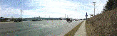
U.S.
29 as it looks today
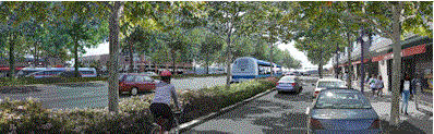
U.S.
29 as local planners envision it
Initially,
the projects ability to ameliorate congestion
will be limited for a couple of reasons. For one,
the design is starkly different from the existing
development around it. The 80-acre site stands at
an intersection of U.S. 29 and Hydraulic Road, a
popular shortcut for locals to the Route 250
Bypass around Charlottesville. Across U.S. 29 is a
Big Kmart. On the opposite side of Hydraulic Road
sits a no-sidewalks neighborhood of small brick
homes. Next door on U.S. 29 is the former plant
for Comdial Corp., a telecom equipment firm.
People
may be able to park and walk around inside
Albemarle Place, but otherwise the place will be
an island. Once youre in, you can get
around, says Alia Anderson, director of the
Charlottesville-based Alliance for Community
Choice in Transportation. But without a car,
getting to the development from anywhere else
is pretty much impossible.
Secondly,
right in the middle of the site is the Sperry
Marine plant, which blocks part of the internal
road network that could help mitigate the impact
on U.S. 29, says John Giometti, the local planning
and land development manager for the Virginia
Department of Transportation. As always with
anything of that magnitude, the devil sometimes is
in the details.
If
the land around the Comdial site next door is ever
redeveloped, it will face the same problem,
Giometti says. If the two properties had been
master-planned and developed as one piece, I think
you would really see the true benefits of this
style of development.
Despite
the difficulties,
there are regional efforts to extend the New
Urbanist approach along the U.S. 29 corridor. Last year the Thomas Jefferson
Planning District Commission and the regions
Metropolitan Planning Organization produced a
105-page report titled UnJAM 2025 that outlined
some options for dealing with the regions
traffic woes. Among its goals is the creation of a
well-connected network of roadways parallel to
major highways.
The
Albemarle Place project is at least an early step
in that direction, says Harrison Rue, executive
director for the planning district commission.
If, as one of a series of similar improvements
along U.S. 29, it provides a piece of parallel
route, and , as other development occurs, we are
able to locate other pieces of parallel routes and
really connect the dots, well have gone a long
way toward solving a lot of the transportation
problem.
Bacon's
Rebellion News Service
July
20, 2005
|