Before
citizens can plan where they want to go, they
must know where they are.
For those who live, work or seek
services in Northern Virginia, this is a
significant problem because it is not clear
where Northern Virginia starts or stops.
Geographic
confusion has a greater impact in Northern
Virginia than anywhere is the United States --
except perhaps Northern California, where
residents periodically attempt to create a
separate state. No one's started a serious secession
movement for Northern Virginia yet, but that's
not for a lack of a distinct regional identity
that some down-staters have jokingly likened
to "the People's Republic of Northern
Virginia" or "Northern Occupied
Virginia."
A
secessionist movement is not likely to ever
get off the ground, if for no other reason
that the organizers are unlikely to ever agree
upon a definition of the region. All
the vituperation and confusion masks the fact
that the official Federal designation based on
the Year 2000 Census indicates that nearly
one-third of all residents of
Virginia
are in Northern
Virginia.
Based on
official and widely-used sources, Northern
Virginia is region populated by 1.36 million
to 3.0 million people -- a difference of 2X
plus. This place, according to these sources,
has an area of between 280,000 acres and
3 million acres -- a difference of 10X plus.
What exactly, and where exactly, is
this mythical place?
The
following is a summary of official
designations of Northern Virginia.
The graphic below tracks the conflict
definitions.
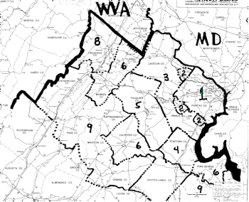
(1)
Northern Virginia is the area
defined by the jurisdiction of the Northern
Virginia Transportation Commission and other
agencies and public offices serving this
geography. This
is the area covered by the widely-used
multi-jurisdictional Northern Virginia
Street Map Book (atlas) published by the
Alexandria Drafting Company (ADC).
This
definition of Northern Virginia includes
the City of Alexandria, the Counties of
Arlington and Fairfax plus the cities and
towns surrounded by these jurisdictions and is
283,000 acres, 1,357,300 population, 4.8
person per acre density.
A
recent use of this definition in the media is
found in Robin Shulman's Loudoun Considers
Buying Bus Fleet, The Loudoun Extra, The
Washington Post,
13 July 2003, regarding the proposed
use of buses to transport Loudoun residents to
Northern Virginia.
This geographic designation, adopted by
many institutions and enterprises, has been
reinforced with references such as Free
delivery within Northern Virginia.
(2)
Northern Virginia is the
contiguous urbanized area in the northern part of
Virginia as designated by the U.S. Bureau of
the Census. While
important for statistical purposes, this area
is not easily identified, and maps are hard to
find. Area
codes recently lost their geographical
meaning. Prior
to that, this geography was roughly the area
covered by Area Code 703.
It was depicted on the cover of some
telephone books.
This
definition of Northern
Virginia covers (1) above plus urban
portions of Loudoun and Prince William
Counties it adds an undetermined area
and population with approximately the same
density.
This
territory is rarely used, even in media
coverage of census data.
For instance, the annual stories of the
Texas Transportation Institutes traffic
congestion report do not note that the
urbanized area is the basis for travel
tabulation for the northern part of Virginia.
(3)
Northern Virginia is the area
covered by the Northern Virginia Planning
District Commission (NVPDC), which was
recently and confusingly named the Northern
Virginia Regional Commission (NVRC) as opposed
to the Northern Virginia Subregional
Commission.
This territory is the same as the
Virginia Department of Transportations
Northern Virginia District (NV VDOT) and the
Virginia portion of the Washington
Metropolitan Area Council of Governments (Wash
COG) membership area.
It is also the jurisdiction of other
institutions and agencies.
This
definition of
Northern Virginia includes (1
& 2) above plus the remainder of Loudoun
and Prince William Counties including the
cities and towns completely surrounded by
those counties, for total of 840,000 acres,
1,935,000 population, 2.3 person per acre
density.
The
media often uses this definition when
reporting on activities of Washington COG,
Northern Virginia VDOT and NVRC.
It is also used to describe the area of
some federal programs.
See Maria Glod's Task Force To Track
Gangs: Area Police Share Fed Grant to Curb
Gang Activity,
Loudoun Extra, The Washington Post, 2
Feb 2003. The article lists the jurisdictions.
(4)
Northern Virginia is the Virginia
portion of the Washington Metropolitan Area
established by the 1980 Census also known as
1983 Washington MSA.
This is the area included in the
Virginia portion of the territory subject to
Federal Air Quality Standards
control of air quality.
This
definition of Northern Virginia includes
1, 2 & 3 above
plus Stafford County for a total of 1,013,000
acres, 2,026,200 population and 2.0 persons
per acre density.
A
recent use in the media is William Banigin's
Stafford Teens Charged in Burglary Ring,
The Washington Post, 14 July
2003. Stafford
County is noted as one of the Northern
Virginia jurisdictions in which the ring
operated. This
is also the Northern Virginia referred to in
all media coverage of air quality in the
National Capital Subregion.
(5)
Northern Virginia is the area of
the Regional Northern Virginia atlas
produced by the Alexandria Drafting Company.
This new atlas contains the Northern
Virginia atlas (1) plus the maps for Loudoun,
Prince William and Fauquier Counties.
The atlas was first published in the
late 1990's.
This
definition of Northern Virginia includes
1, 2 & 3 above plus Fauquier County for a
total of 1,280,000 acres, 1995,000
population and 1.6 persons per acre density.
Media
coverage for definitions (5) through (9) is
too confusing to sort out in this context.
In general, the regional press
and media outlets use varying geographies for
Northern Virginia which include these areas,
especially in sports, business and lifestyle
coverage. The
community media in the jurisdictions outside
(3) almost always refer to Northern Virginia
as being over there, a place apart from
their community.
Enterprises, institutions and agencies
use differing geography depending on whether
they seek to be inclusive or core focused.
(6)
Northern Virginia is the Virginia
portion of the Washington-Baltimore
Consolidated Metropolitan Statistical Area (CMSA)
and the Washington Primary Metropolitan
Statistical
Area (PMSA) as established by the 1990
Census. As noted in (7) below, this geographic
configuration has been superceded by the 2000
Census, but it has become implanted in a
number of formal and informal territorial
agglomerations.
This
definition of Northern Virginia includes 1, 2,
3, 4 & 5 above plus Clark, Culpeper, King
George, Spotsylvania and Warren Counties and city
of Fredericksburg for a total of 2,305,000
acres, 2,308,100 population and 1.0 persons
per acre density.
(7)
Northern Virginia is the Virginia
portion of the Washington PMSA as established
by the 2000 Census.
Between the time the Census Bureau and
the Office of Management and Budget designated
MSAs, PMSAs and CMSAs based on the 1990 Census
covered by (6) above to those geographies
based on the
2000, Census the definitions were
changed.
The
change in definitions was made in reaction to
the pressure from congressional offices,
municipal officials, local chambers of
commerce and others.
These entities did not want urban
enclaves in their territory to be subsumed
under the name of the regions core
jurisdictions from which they desire name
differentiation, whether or not economic,
social or physical differentiation exists in
reality. The
reality of interconnection is, of course, the
reason for calling the entire area Northern
Virginia.
Two counties, Culpeper and King George,
were dropped from the 1990 Census
PMSA because the commuting percentage
does not meet the new minimum standard.
This
definition of Northern Virginia includes
1, 2, 3 & 6 above minus Culpeper
and King George Counties for a total of 2,060,000
acres, 2,254,600 population and 1.1
persons per acre density.
(8)
Northern Virginia is the Virginia
portion of the Washington-Baltimore Consolidated
Metropolitan Statistical Area (CMSA) as
established by the 2000 Census.
As noted in (7) above, the Census Bureau
definitions have been changed. The
result is that the Washington-Baltimore CMSA is
now larger than the CMSA based on the 1990
census because it includes the new
Metropolitan and Micropolitan areas
centered on Winchester, Va., and Chambersburg, Pa., as
well as Cambridge, Easton, Hagerstown and
Lexington Park, Md.
Questions about these new designations
are legion.
This
definition of Northern Virginia includes
1, 2, 3 & 7 above plus Frederick County and
the City of Winchester for a total of 2,360,000
acres, 2,341,600 population and 1.0 persons per
acre.
Only
when one reaches definition (8) does it include
Frederick County which includes the northernmost
territory in Virginia.
(9)
Northern Virginia is the Virginia
portion of the Washington-Baltimore New Urban
Region (NUR). Those
who have read The Shape of the Future
understand the regional reality of this
geographic agglomeration.
This
definition of Northern Virginia includes 1, 2,
3, 6 & 8 above plus Caroline, Lancaster,
Madison, Northumberland, Orange, Rappahannock,
Richmond and West Moreland Counties as well as
portions of Essex, Page and Shenandoah and other
counties for a total of 3,000,000 +/- acres,
2,600,000 +/- population and .9 persons per acre
density.
And
now, to move from the subregion to the region...
The
above geographic entities listed above are
candidates for Northern Virginia or the
Virginia Subregion of the National Capital
Subregion of the Washington-Baltimore CMSA and
of the Washington-
Baltimore
NUR. One
would be correct to assume there is an even
wider range of possibilities for definitions of
the multi-state National Capital Subregion, the
Washington-Baltimore CMSA and the
Washington-Baltimore NUR.
It
is reputed to be unpopular to be part of a subregion.
This is strange because many are proud to
be in what is called a suburban area.
Region
and subregion are relative terms.
Both must be used with modifiers to
identify which region or subregion is being
referred to. Since
northern Virginia means different areas to
different people using Northern Virginia
without a modifier is misleading.
So,
what different does it all make?
Why
is knowing where you are (aka, geographic
literacy) so important?
My book, The Shape of the Future,
devotes most of Chapters 3 and 16 to this
question. Perhaps
a paraphrase of an ad for The Washington Post
sums it up best: If you dont know what you
are talking about, you dont know what you are
talking about.
Nowhere
is this dictum more clearly illustrated than by
media coverage that refers to Northern
Virginia but does not say which Northern
Virginia the writers are referring to. See, for
example, Kenneth Bredemeier's Tennessee Bank
Plans Virginia Debut, The Washington Post,
page E-1 21, July 2003.
It
is imperative to understand geography in order
to understand the economic, social and physical
parameters of creating a sustainable future.
One of the foundations of dysfunctional
human settlement patterns is citizens failure
to comprehend the consequences of the decisions
that they make.
--
August 11, 2003