|
It
is time for everyone to get on board the train
for Dulles. By this we mean:
Unless
all the stakeholders who want to see METRO
extended to the Centre of Greater Tysons
Corner and on to Dulles International Airport
get on the same train very soon, there will be
there will be no METRO extension to Dulles.
(See End
Note One.)
There
may be future options to connect the Centroid of
the National Capital Subregion with Dulles
International Airport via a shared-vehicle
system, but not with a METRO extension. Further,
we predict that any new system a sketch
outline of such a system can be found in Rail-to-Dulles
Realities (Jan. 5, 2004) will be a
long, long time in coming.
Those
who follow The Shape of the Future
columns may jump to the conclusion we have
written all we could about Rail To Dulles.
(See End
Note Two.) That is not the case. In the
light of recent events and further analysis,
this column rearticulates, expands and amends
what we wrote about METRO to Dulles in September
2006 (Two
Steps Backward) and in recent posts on
the Bacon's Rebellion Blog.
The
Headlines
The
30 March Dulles Transit Partners, LLC, press
release and the 31 March WaPo coverage
seems to close the door on a tunnel for a METRO
line through Greater Tysons Corner. (See Contract
Set for Rail Line To Dulles: Prospects Look
Dim For Plan to Tunnel Beneath Tysons Corner
by Bill Turque, and End
Note Three.)
The
new contract may not end the tunnel vs
overhead debate. However, further arguments
over tunnel vs overhead will compound the
already substantial hurdles to be overcome if
there is to be METRO compatible
Rail-to-Dulles in our lifetimes.
This
was the message of Doug Koelemays column in
the 21 March edition of Bacons Rebellion (Tunnel
Vision). Koelemay expressed well the
do not let the perfect chase out the good
argument that is a mantra of Business As Usual.
In this case, Koelemay is probably right. There
are so many other barriers that a prolonged
tunnel vs overhead conflict may kill the project
as now envisioned. METRO is a 50-year-old
technology, and few citizens favor the high-density
settlement pattern that METRO-like systems best
support.
There
is another important reality:
If
METRO through the Centre of Greater Tysons
Corner consists of an elevated track that in
any way resembles the graphics that the WaPo
has published, it will be the kiss of death
for any evolution of Greater Tysons Corner
into a functional, urbane, much less Balanced,
Community.
If
the photo simulation of the proposed rail
is representative of what is actually built,
there is no way to put lipstick on this pig. The
overhead photo simulation is not merely ugly: A
METRO line on stilts in a roadway median will
not provide mobility and access for Greater
Tysons Corner. This configuration will leave the
Autonomobile as the preferred way to get to,
from and around-in the Centre of Tysons Corner.
Roger Lewis articulates this view well in Why
Going Underground Makes Sense in Tysons
Corner in the 17 February 2007 WaPo.
Upon
Further Review
Back
in September we castigated Governor Kaine for
withdrawing his support for tunneling under all
of Tysons Corner (Two
Steps Backward, 17 September 2006).
Conventional wisdom holds that the only
civilized way to locate a high-capacity,
shared-vehicle system in an urbanized area is to
put it underground. Many also argue that
tunneling is the only strategy that makes
economic sense in the long-term. Based on past
experience, elevated lines are often equated
with blight. See the Roger Lewis column cited
above.
This
preference for underground Metro is based, in
large part, on the fact that almost all good
examples of high-capacity,
shared-vehicle-system-served urban fabric have
the transport system underground. The
Underground (aka, Tube) in London, Metro in
Paris, U-Bahn in Berlin, Tunnelbanan in
Stockholm, Subway in Toronto, BART in San
Francisco, MARTA in Atlanta almost every
high-capacity system in the First World (except
Miami) runs primarily in tunnels within the
Centre (aka, downtown). Closer to home,
tunnel advocates point to the Centre of the
Federal District and to the Rosslyn-Ballston
Corridor.
Upon
further review the absolute necessity for a
tunnel is not as clear cut as I suggested it was
in September:
-
In
all of the examples cited above, the pattern
of land ownership (and buildings) as well as
the streets and roadways to serve urban land
uses were in place before the shared-vehicle
system was installed under the already-urban
streetscapes. For reasons we will explore in
some detail below, this is a critical issue.
This condition is unrelated to the broad
arterial rights-of-way that the METRO line
extension is planned to follow through
Greater Tysons Corner.
-
In
the Two Steps Backward column we
spelled out several possible silver linings
from the Kaine decision. One was the
potential to abandon all efforts to save
Tysons Corner and to shift the focus of
urban activities in the Radius = 5 Miles to
Radius = 25 Miles Radius Band from Greater
Tysons Corner to Greater Reston, Greater
Fairfax Center, Greater Springfield, etc.
This silver lining assumes that there
will be the public and private resources
necessary to cover the cost of abandonment
and rebuilding elsewhere the urban fabric
capacity that is now present in the Centre
of the largest Beta Community in the
Virginia portion of the National Capital
Subregion. That well-spring of resources may
not exist in the future.
-
Finally,
and most importantly, the National Capital
Subregion is facing a major Mobility and
Access Crisis (as well as an Accessible and
Affordable Housing Crisis and a
Disaggregation of Settlement Pattern Crisis)
that is already impacting every citizen of
the Subregion and of the Washington-
Baltimore New Urban Region.
As
we have been arguing since 1982 and have been
writing for the last 20 years, METRO is the only
mobility and access system that has excess
capacity. Most METRO trains still leave most of
the METRO stations most of the time essentially
empty. (See It
Is Time to Fundamentally Rethink METRO.)
A
key to solving the crises facing the National
Capital Subregion is to rationally use METRO
station areas and the METRO system capacity.
Intelligent design, and implementation of METRO
in creating Rail-to-Dulles and Rail-to-Tysons
Corner, could be an important first step.
The
next Rail-to-Dulles milestone is May, when the
Federal Transit Administration is scheduled to
conclude a risk assessment. The biggest
risk is that someone in the administration
will see federal money spent for Rail-to-Dulles
as a threat to some other administration
program. The more parties that are on the same
train, the less likely any individual obstacle
will kill the prospect of Rail-to-Dulles for the
foreseeable future.
We
also have a personal reason to look for a basis
for consensus. We have traveled to Cleveland,
Chicago and Atlanta to ride the shared-vehicle
system to the airport. We have gone out of our
way to do the same in Paris, Roma, Munchen and
London. We hope to do the same in Dulles, having
been professionally involved in Rail to Dulles
since the early 80s.
Some
will recall that we suggested repeatedly, from
the mid 80s onward, selling the National Airport
site and using the funds to extend METRO to
Dulles Airport. Given the...
-
current
expansion of Dulles capacity
-
flat
air travel demand since 11 September 2001
-
growing
concern for noise generated by flights to
and from National Airport, and
-
many
good economic and ecological reasons that
air travel numbers should not grow
...the
sale of the National site might have been a very
good idea.
The
Sale of National ideas time may come
again. Think how much better it would have been
to have the Air and Space Annex at a METRO stop
and a historic airport. But that is another
story.
Broad-Based
Support
Right
now it is hard to find anyone who thinks it is
not a good idea to extend METRO to Tysons
Corner. Support for extending METRO to Dulles
via Greater Reston is almost as strong. That has
not always been the case. (See End
Note Four.)
Right
now it is hard to find anyone, except a few who
live very close a specific rail station, who
does not think it is a good idea to put
intensive development in METRO station-areas. In
March, the Fairfax County Board of Supervisors
adopted a new policy on this issue. The 13 March
2007 WaPo article, Dense
Development Sought Near Transit: Fairfax
County Policy Will Promote Pedestrian-Friendly
Areas Near Stations, by Amy Gardner and Bill
Turque is a generally factual report of what
went on when the Board of Supervisors adopted
new, and very intelligent, .25- and .50-mile
radii policy criteria for METRO and VRE station
areas. The story is, however, woefully weak with
respect to the history of METRO station-area
policy and action in the County.
This
level of citizen and political leader
support has not always been present. Support for
specific station-area, METRO-related development
was written into the Comprehensive Plan in the
70s but removed in the 80s. (See End
Note Five.)
Even
many of those who live near a METRO station and
do not want transit-oriented development
at their station agree that, in general,
METRO-supportive station-area development is a
good idea. Many think that station-area
development should be a monoculture but that is
also another story.
A
Different Vision
Given
the fact that the existing development in the
Centre of Greater Tysons Corner is nothing like
what existed when METRO came to the Centre of
the Federal District or to the Rosslyn-Ballston
Corridor, the Four Billion Dollar Question
is:
What
could be done in the Centre of Greater Tysons
Corner so that METRO on stilts does not look
like the current photo simulation?
Let
us wipe the slate clean and consider a real
alternative to a tunnel or a naked track on
stilts in the median of a busy arterial.
The
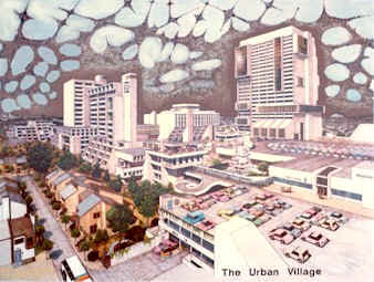
first image of a real station-area alternative
that I recall seeing was a low oblique
perspective of a multi-use, shared-vehicle
station-area termed The Urban Village.
It was drawn by Richard L. Thornton in the early
1970s. Rich was a recent Georgia Tech
graduate in architecture who worked with me at
RBA (nee, Richard Browne Assoc.) As I
recall, Richs sketch was drawn to illustrate
what a station area might look like in connection
with RBAs bid to do design work on the East
Line of MARTA in the Atlanta New Urban Region. (For
background of this and related drawings by
Thornton See End
Note Six.)
Other
illustrations may have predated Thorntons
drawing but his is the one that sticks in my
memory. The image was more complex more
buildings, more architectural interest and
larger in scale but had some of the flavor
of the Disney World Contemporary Hotel, which
had a monorail station in the lobby.
Thorntons
drawing represented a fundamental shift from the
schematics that influenced the design of the
above- ground METRO stations in the National
Capital Subregion, the BART stations in the San
Francisco New Urban Region and later the MARTA
stations.
Richs
graphic was also dramatically different than the
recent renditions of transit oriented
development by New Urbanist designers. New
Urbanist drawings almost always have the station
located at the edge of a meadow or facing a
large plaza. (That is, if the station is not
underground along a boulevard that looks like
Champs Elysees.) The town square
station-area is a pleasing visual element and it
allows the transit operator to see their pride
and joy the station and the train front
and center across a greensward or plaza.
Architects
of all persuasions (and their clients) prefer to
show off their buildings fronting on a plaza or
other open space. Most of the graphics depicting
shared-vehicle stations (and the design of the
stations) are paid for by the shared-vehicle
system operator or by those who want to please
or impress the system operator.
On
the other hand, what shared-vehicle system
riders do not want when they step from the car
onto the platform is the prospect of a long
escalator to ride, a wide street to cross or a
long pedestrian bridge to navigate. They
especially do not look forward to a big plaza or
greensward to slog across especially in hot,
cold or wet weather.
Most
riders got onto the system to travel to a
destination and that destination is not often a
park. If a park is the destination, then the
park should be a main use in the station area
such as the Montreal Zoo at the Angrignon
station. In most cases the open space should be
accessible but not take up the space between the
car door and the destinations of the majority of
the riders.
Marriott has for several
years advertised the redesigned of Courtyard by
Marriot hotels as being designed by business
travelers, for business travelers.
Shared-vehicle systems need to be designed by
system riders for system riders. If they were,
they would look more like Rich Thorntons
drawing and less like a station in a park.
Pyramid
Strategy, Not a Pyramid Scheme
From
a distance a station-area should look like an
attractive, well-articulated pyramid with
the highest intensity of land use (and thus the
centroid of origins and destinations of travel)
close to the center where the platform is
located and with lower-intensity uses feathering
out from the center.
In
fact this is exactly what a shared-vehicle
system does under market conditions unless
governance land-use controls interfere. The
Montreal Metro was developed as a part of the
EXPO 67 (1967 Worlds Fair) initiative. We recall
looking out across the Centre of Montreal from the
roof of a downtown hotel just a few years after
the Metro system opened. By 1968, one could
already identify the locations of the stations
by the clusters of new buildings at the Metro
station sites. Now a visitor does not need a map
to follow the Metro lines when the Core of the
New Urban Region is viewed from Parc du
Mount-Royal. The same is true for the Subway in
Toronto when viewed from the CN Tower.
Both
Montreal and Toronto New Urban Regions have made
far better use of shared-vehicle systems in
shaping the urban fabric than have New Urban
Regions in US of A. For example a more
disaggregated pyramid form can be observed in
the aerial views of the RosslynBallston
Corridor found in Blueprint. A close examination
of a the RosslynBallston Corridor air photo
with .25 and .50 mile radii circles shows that
much of the prime access (aka, front hook)
area is taken up by streets. That is one reason
we have created the sketch plan process that
follows.
But,
first, an overarching station-area concept is
important to bear in mind: The METRO station
must be integrated into the surrounding urban
fabric. (For a survey of examples from Europe
and the US of A, see End
Note Seven.)
From the outset METRO has been
about building a railroad and not about
creating functional urban fabric. There are
thousands of examples from Wien to Vancouver and
from Oslo to Madrid where below-grade, at-grade
and above-grade stations could have been
improved and still could. It took a third of
century to finally start to cover the
escalators.
With all these shortcomings, the
worst mistake has been the failure to
accommodate the interest and need of METRO
passengers to access the places they are going
to into the design of the facilities.
Why
"Transit" Works
It
is important at this point to make it very clear
how and why high-capacity, shared-vehicle
systems support functional settlement patterns
in a METRO station area.
Shared-vehicle
systems do not provide access and mobility
because all those who live, work or seek
services and recreation in the station-area
jump on the train to meet their every travel
need.
Shared-vehicle
systems "work" because they support some
high-value trips for many who live, work
or seek services and recreation in the
station-area. By doing this, the shared-vehicle
system facilitates and serves patterns and
densities of land use that allows most
workers, residents and visitors to meet many of
their needs without resorting to any vehicle.
Many
mode split calculations intended to show
that transit only serves a small percentage of
the travel demand are bogus because they do not
address the ability of many in well functioning
station-areas to assemble a quality life without
using any vehicle.
Many residents can
prosper with an occasional vehicle rental, a
shared private vehicle (formal zip car,
etc,. or informal) or at most one car per
household. Further, the autonomobile trips they
do take are often in off peak times and
directions. Beyond that, the vehicle storage
(parking) can be at the fringe of the station
area and does not disaggregate the critical,
synergistic elements of the station-area
settlement pattern.
In
summary: The flux of activity (aka, land use
density / intensity) supported by
high-capacity, shared-vehicle systems such as
METRO allow many trips that would
otherwise be vehicle trips to become stops
on a pleasant walk. The key here is
pleasant. More on that below.
The
requirement to meet a range of needs is why
station-area land use mix and Balance is
so important and why system-wide Balance of all
station-areas is required to maximize the
functionality of any shared-vehicle system.
These are the reasons a station area Pyramid
Strategy is so important.
A
Do-It-Yourself Sketch Plan Process for Readers
The
design and function of shared-vehicle system
station-areas are critically important because:
Functional
station areas are critically important because
Autonomobile- dominated settlement patterns are
dysfunctional and cannot provide mobility and
access for large New Urban Regions.
How
does one lay out a shared-vehicle
system-serviced Centre for Tysons Corner?
The
following is what every citizen should have
learned in grade school along with why it is
important to get enough exercise and sleep, eat
the right foods and avoid excess television and
video games. (The prerequisites of enough sleep,
good food and avoiding the illusion of escape
via television and games were laid out in Jim
Bacons column, "Brain
Games," on 2 April, 2007.)
Patrick
Kane has shown by his Boom Town
interactive game that fourth graders have the
experience and knowledge to intelligently lay
out Planned New Community components (and thus
shared-vehicle station-areas). They are
better equipped for this task than adults. In
fact, they are far more adept at creating
Balanced sketch plans than teams of
professionals.
Until
there is a revised public school system and a
well-informed staff in the Main-Stream Media you
are going to have to do the job yourself. Here
is the first of two sketch exercises:
The
18 February 2007 WaPo lead Metro Section story
headline reads: Next
Stop, Tysons: Fairfax County Planners See
Ballston Neighborhood as Model for
Transit-Oriented Overhaul of Sprawling Business
Center. The story by Alec MacGillis compares
Tysons Corner to the RosslynBallston
Corridor. (See End
Note Eight.) For now the important thing is
that the story includes a somewhat out-of-date
air photo of the Centre of Tysons Corner via
Google with the four proposed METRO stations
located.
The
following is a step by step walk-through of the
process that allows readers to create a
quantified sketch plan for the four Greater
Tysons Corner METRO stations. We could just
provide a graphic and go on but it is much more
effective if the reader does the drawing and the
calculations. We provide metrics to help guide
the process and our version of the exercise as
Graphic One in the Gallery at the back of the
End Notes.
| Step
One: |
Go
to the print edition of the 18 Feb WaPo
story about Greater Tysons Corner and the
Rosslyn Ballston Corridor. Take the photo
of Greater Tysons Corner to the copy
machine and blow it up 200 percent. (In
the alternative, use the air photo at the
current scale with a magnifying glass.)
You can use any current air photo of
Tysons Corner and then locate the stations
from the WaPo story or other sources.
Using a map rather than an air photo will
distort the results due to factors
explored in Chapter 16 of the Shape of the
Future. |
| Step
Two: |
This
is the important part: Draw Circles with
.25 (1,320 feet) and .50 (2640 feet) radii
around the four stations. The R=.25 circle
contains 125 acres, the R=.50 circle
contains 500 acres. |
The
first thing you will notice is that much of the
land within .25 miles (1,320 ft.) of the station
platform is within public right-of-way. This
should set off alarm bells. Building a Four
Billion dollar METRO extension and then
reserving the land accessible to the most
important stations for roadway makes absolutely
no sense -- regardless of whether the train is
in a tunnel or on stilts.
The
second thing to note is that the existing
concentrations of buildings, e.g. those along
the Dulles Access Road, are some distance from
the stations. Many of the largest existing
buildings fall in the R= .50 mile circle and
many are more than .50 miles from any station.
This provides a glimpse of how much vacant and
underutilized land there is if the existing
right-of-way determines the METRO alignment. The
distance of the stations from concentrations of
trip ends is a result of letting roadway
alignments determine the track layout.
The
next step is to quantify the air photo with the
four bulls-eye station areas:
Get
out a calculator, a ruler and a blank sheet of
paper. To answer the question,
How much land is in the public
right-of-way, one needs a ruler and one
metric: There are 43,560 square feet in an acre
of land. Use a ruler and the scale of the map to
figure up how many square feet are in the
right-of-way. One can also figure up how much
private land outside the right-of-way is within
.25 miles and is vacant or underutilized.
To
answer the question, How much building area
would this land support, one needs an
additional metric: The Floor Area Ratio (FAR)
over the entire area within .25 miles of the
METRO platform (125 acres as noted above) might
rationally be pegged at 8.0 for a system with
METROs capacity.
To
answer the question, How much is the building
area over public right-of-way worth, one
needs an additional metric. An average value of
$300 per square foot of built space would be a
conservative benchmark.
The
totals may vary from reader to reader in this
sketch plan process depending on the assumed
location of the edge of the right-of-way. The
way we figure it, within .25 miles of the
platform at FAR 8, the potential exists to build
about 14 million square feet of space per
station, and with a pyramid configuration, about
six million square feet over the right-of-way at
each station. Most important is that all of
the most valuable space the tallest part
of the pyramid is located over public
right-of-way.
That
should be seen as a very good thing. The public
already owns land that will be much more
valuable when the public invests in a METRO
platform in the right of way. More on that
later.
To answer the last question, readers need
to decide how much a square foot of building is
worth. Todays prices ($300 per finished square
foot) implies a value of $1.9 billion worth of
Class A space for each of the four stations. How
much would a knowledgeable developer pay for a
99-year lease to build six million square feet
over a public right of way adjacent to a METRO
platform? That will depend on what conditions
are put on the sale but it is a good guess that
it would be enough to pay for an extended
platform and for enhancements plus a
contribution to cover other capital costs of
extending METRO.
Before
we start counting the public revenue chickens,
there is one big constraint. The development
over public land for the four stations at FAR 8
totals over 24 million square feet, and within
.25 miles the total is more than 56 million
square feet. It will take years for the market
to adsorb that much space. All of Greater Tysons
Corner now totals in the neighborhood of 35 million
square feet of non-residential space.
From
our first sketch exercise we can conclude that
if we run METRO under or over VA Route 123 and
VA Route 7, there is a huge difference between
using or not using the land over the public
right-of-way.
So,
let us stop for a moment and consider what it
means for the public to own this land.
Public
Way Rights
The
term air rights carries unfortunate
connotations, as if the right to build over
public rights of way was something airy, or
lacking in substance. The expression also stirs
up Business-As-Usual forces, who go to great
lengths to discredit it. Accordingly, it seems
wise to coin a word that puts the focus on the
public interest. Henceforth, we call the right
to build over public rights-of-way Public Way
Rights.
Building
the area around METRO stations to optimum
density generates hostility from adjacent
landowners. While they are keenly aware
development over the public land would make
their own land more valuable eventually, they
would have to wait until a market materializes,
and the interest clock is running on their own
investment. One way to sweeten the pot for
adjacent owners is to give them a right of first
refusal and/or a density bonus if the public and
private land in any quadrant of a station-area
is developed as a single, phased project.
This
incentive was built into the 70s-era Fairfax
County Comprehensive Plan for the Vienna /
Fairfax / GMU station-area and wiped out by
the actions of Del. Scott and Supervisor Hanley,
as noted in End Note Five.
The
reason readers have not heard much about Public
Way Rights in the discussion of rail-to-Dulles
is that Greater Tysons Corner land owners would
not benefit as quickly from METRO if the most
important station-area land was developed first.
These propertied interests have paid for
studies, made political contributions to
officials at the municipal and state levels,
funded much of the earlier tax district
phase of the Rail to Dulles effort as noted in
Rail-To-Dulles
Realities, and they funded
TysonsTunnel.org. They want pay-off sooner
rather than later.
One
cannot blame these parties for wanting to
build on their own vacant and underutilized
land. But this is where those elected to
represent the public need to step in to create
a balance of public and private interests.
Readers
also will not hear about Public Way Rights from
those who want to get the contract to build the
rail system because they would not make more
money from such a strategy. Indeed, under a
Public Way Rights arrangement, station-area
developers would play a key role at each station,
which might reduce the role of, and the payoff to,
the system builder.
Readers
will not hear about Public Way Rights from
governance practitioners because it is the land
owners and those who want to build the railroad
who make the political donations.
The
only constituency that would really benefit from
extensive use of Public Way Rights would be the
system riders and the general public, and they
do not yet understand why they should be
interested. That is why education and general
public understanding is so important. WaPo
has spilled a trainload of ink on Rail to Dulles
and,
still, most citizens have no clue what
their stake is in either Rail-to-Dulles or
Rail-to-Tysons.
The
bottom line is that Public Way Rights are a
key to access and mobility in Greater Tysons
Corner -- whether METRO is in a tunnel or on
stilts.
Development
over public rights of way provides far greater
connectivity between METRO and the places
the METRO riders want to go. Connectivity
is the term Patrick Kane has used in his
teaching, consulting and writing on Rail to
Dulles.
In
fact, Public Way Rights are not just a good idea
in Tysons Corner but in many other places as
well. We have noted elsewhere that the 45 acres
of potential Public Way Rights in the
Vienna/Fairfax/GMU station area would
accommodate all of the AOL and WorldCom campus
jobs as well as places where many workers could live and seek weekly
services. And that was when their buildings were
fully occupied.
Across
the US of A, some of the land best
located for urban uses is now devoted to
over-designed 1950s cloverleaves at 150
acres at a pop. (See End
Note Nine.)
To
Tunnel or Not to Tunnel
Now,
let us explore the question of a tunnel vs an
overhead METRO line: Take a look at photo in 13
March or the 31 March WaPo stories. It looks
bad, but if we hire an Italian engineer, paint
the stilts sky blue, plant a lot of trees...
No, cosmetics will not help.
The
first thing to do is look at the air photo and
the bulls-eyes in the first sketch exercise. It
is clear that with...
...there
would be very little naked elevated track visible.
This fact weakens the eye-sore argument.
(See End
Note Ten.)
Now,
let us turn to the real reason citizens will
ride the METRO extension to, from and between
stations in Greater Tysons Corner, and the
reason that a tunnel may not be as good as an
elevated line.
It
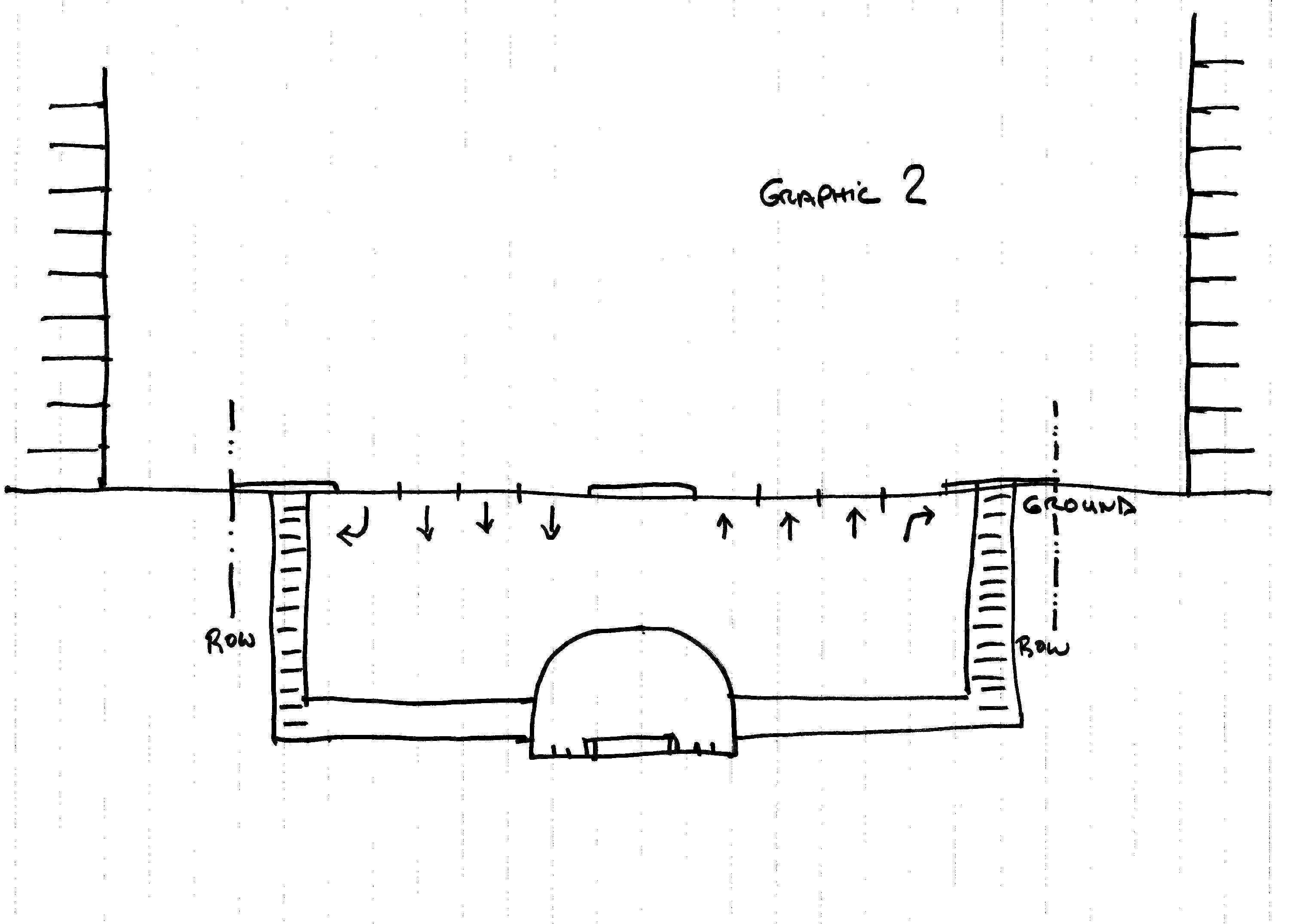
is time for more sketches: We provide our own
version of these sketches in Graphic
2, Graphic 3 and Graphic
4
in the Gallery at the end of the End Notes but
it is much more effective if readers do the
sketches themselves.
| Step
One: |
Take
out three pieces of lined tablet paper.
A legal pad works well for this exercise.
On the first sheet draw a vertical line
down the middle of the page, then turn the
paper to the landscape orientation
and label this line ground.
|
|
|
| Step
Two: |
Select
a scale for your sketch 30 feet to the
inch works well because the distance
between the lines on a legal pad are about
10 feet at 30 feet-to-the-inch. This is
also the nominal distance from one floor
to another. Do not have a scale? Make one
by marking off the tablet lines widths on
a 3X5 card to create a 30-scale ruler in
10-foot increments.
|
|
|
| Step
Three: |
On
your first sheet, scale off 150 or 250
feet the right of way for VA Route 123
and VA Route 7 varies through the Centre
of Tysons Corner. Now, in the middle of
the street go down 30 feet and draw an
archway representing the METRO tunnel at a
station with platforms.
|
|
|
| Step
Four: |
Next,
assume the same station design criteria
for underground stations as the existing
stations in the Rosslyn Ballston
Corridor. (The streets in the R-B Corridor
are far narrower but we will get to that
in a moment.) Because most folks want to
exit the station on a sidewalk, not in the
median, draw tunnels to within 10 or 15
feet of the edge of the right-of-way and
then add escalators. Pause to envision the
fun one has walking in the pedestrian
tunnel under the street. (Hint, it is
similar to the walk from the station
platform to the plaza at the Courthouse
station.)
|
|
|
| Step
Five: |
Finally,
on this first sketch, go outside the right
of way five or 10 feet and sketch in the
buildings at 10 or 20 stories. Now, set
sketch aside for a moment.
|
|
|
| Step
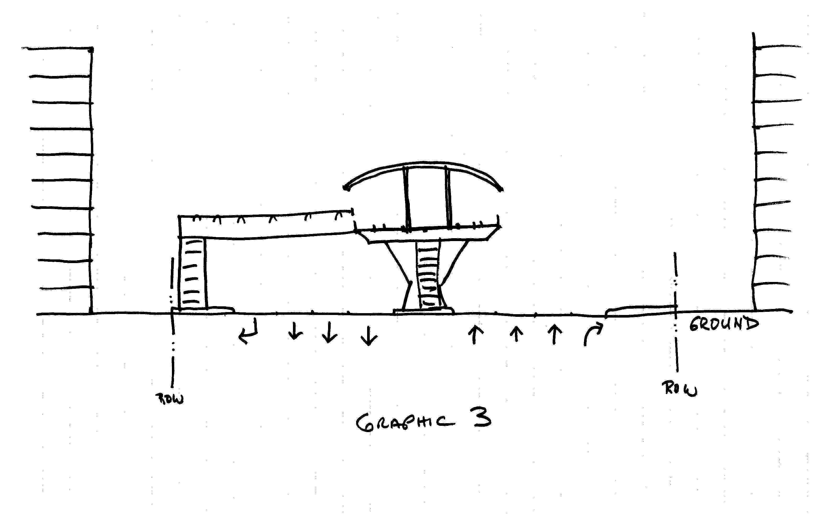
Six: |
On
the second sheet draw in the vertical
line, turn the paper to landscape
orientation and put in the roadway
right-of-way. Next locate the track level
30 feet in the air. Now sketch in the
track and station platform based on the
photo simulation that WaPo has published.
Next, add the stairs/ escalators over or
under the tracks to get from one platform
to the other and the cross-walks or
pedestrian bridges to get to the
sidewalks. Next, add the buildings. If you
want to be fancy, put in both ground and
elevated level entrances to the
buildings.
|
|
|
| Step
Seven: |
We
are almost done. Take the third sheet of
paper and follow the same steps as in Step
Six up to the track and station platform.
Next, draw horizontal lines every 10 feet
to represent the floors of a structure
built on air-rights over the right of way.
The lines can go all the way to the edge
of the paper. Now take an eraser and
create atria, walkways and plazas where
ever they will work well. The level
between the street and the platform can be
a service level for deliveries, storage,
and utilities.
(Parking
for the buildings, greatly reduced thanks
to METRO access, would be located off the
drawing in locations convenient to
surrounding streets, not from the arterial
that conflicts with the pedestrian
movements.) |
Now, let us assume you have a 10 a.m. meeting in
the building closest to the Tysons 123"
station platform. Which sketch works best for
you? When citizens get on a shared-vehicle
system, it is not to joy ride but to get to
where they want or need to be. We know that the
closer to the car door the destination is, the
more likely citizens are to ride a
shared-vehicle system.
In
your diagrams, which scheme has the greatest
access to origins and destinations for
shared-vehicle system riders in the buildings
closest to the station platform?
If
one assumes a station-area pyramid of land-use
flux, which of the station area cross section
sketches serves the most riders and eliminates
the most need for Autonomobiles?
The
Magic One Quarter Mile
When
discussing station-area planning, one frequently
hears that .25 miles is a magic number and the
limit of shared-vehicle system impacts. Others
say some will walk farther but that no-one
will walk more than .50 miles. These arbitrary
numbers are silly. Distance and other barriers
of pedestrian travel in the station-area are
psychological as well as physical.
The
key to pedestrian travel is interest and
ability. Most will cross a street to be in
contact with their love interest. A few look
forward to a walk from Springer Mt., Ga., to Mt.
Katahdin, Me.
How
far a person is willing to walk depends on
interest, time, resources, and health/mobility.
The key for most walkers is to make the
station-area travel diverse, complex,
stimulating, but above all
interesting/satisfying and safe. For some that
requires higher levels a security/ safety, for
others higher levels of diversity, interest and
excitement. That is why a functional station
area must have a network of pathways that
provide a variety of alternative experiences and
a minimum of obstacles like wide streets, long
tunnels, long empty bridges, abrupt changes in
level, etc.
The
word willing in the phrase willing to
walk is also critical. In our years living
and working on small Caribbean islands, we
seldom found workers who would rather walk to
town, regardless of the spectacular scenery.
When they did, there was always someone or
something they hoped to encounter along the way.
The
same parameters, as we will see in Exercise Two,
apply to above or below ground. As with other
parameters we call The Natural Laws of Human
Settlement Pattern, the exact radial distance
from the station platform is not the issue. The
design of the station area should rely on three
factors. Functional station-area strategy is a
matter of:
-
Scale
-
Intensity
and Flux
-
Balance
Scale.
With respect to scale, if one uses a .50-mile
radii, then the Village Scale station-area is a
mile from edge to edge. It is not the station
platform alone that should be accessible but the
entire station area.
Intensity.
If there are 500 acres in the station-area (.50
mile radii) then one spreads out the uses and
there is a loss of connectivity, adjacency and
synergy. In terms of form for a large
station-area, think mesa rather than a
pyramid. A station-area of 500 acres at
higher intensity (2.5 vehicle trip ends per
square foot of ground) requires three system
stations with METRO capacity (or two stations
serving different systems) such as the Centre of
Paris served by Metro and RER.
Balance.
The big issue is Balance. The station area needs
to be large enough to have Alpha Village scale
diversity and small enough to have functional
access to the destinations needed to assemble a
quality life.
Mystique
of the Grid
Yes,
pedestrian spaces for strolling and sitting
along urbane boulevards can be attractive
in good weather. These amenities can be
accommodated in the Pyramid Strategy but they
would be on streets running perpendicular
to the METRO line. Before going whole hog for
sidewalk cafes, however, consider how many
people really like to sit along a boulevard
carrying as much traffic as VA Route 7,
especially when it is cold, hot or wet?
When
planning to introduce a new shared-vehicle
system, a grid is fine if the grid already
exists. The street and ownership pattern
provides an historical and psychological
orientation to the redevelopment that will
result from added access and mobility provided
by the public investment in a shared-vehicle
system as happened in the RosslynBallston
Corridor.
A
grid of streets is not a cure-all to solve
Tysons Corner access and mobility dysfunction.
What is important is a web of pedestrian
access, not streets to accommodate
Autonomobiles or roadways that are dominated
by Autonomobiles. (See comments in the
Bacon's Rebellion Blog Ballston
on the Half Shell.)
Public
Way Rights and Pyramid Strategy development can
create a grid of pedestrian access but it will
not be simple to design or cheap to build. Yes,
there can be tree-lined boulevards with sidewalk
cafes in some locations and, yes, ventilation
and sound deadening will be more expensive, and,
yes, views can be provided... (For further
exploration of the shortcomings of the grid, See
Myth of the Grid Sec X, # 5 in Handbook,
First Edition.)
The
bottom line is citizens are spending $4 billion
to build a system to get as many citizens as
possible from where they are to where they
want or need to go. It is clear that Public
Way Rights and Pyramid Strategy are the way to
go, be the rail line tunneled or elevated.
Unfortunately,
despite many examples of this sort of
development, these ideas will never see the
light of day in MainStream media because none of
those who have staff, hire consultants and
public relations spinners and write press
releases are interested in solutions that
are anything beyond Business As Usual.
Prize-Winning
Illustration
Exploration
of a fundamentally different station-area design
strategy brings out the dissenters just like air
rights and Henry George. (See End
Note Eleven.)
The
discussion of the Fundamental Changes to the
tunnel and the grid raises
many questions, among them are:
Given
what you have learned from these two exercises,
how does one illustrate the wisdom of using the
land that citizens already own to support
evolution of functional settlement patterns
supported by the extended METRO system?"
How
does one illustrate the shortsightedness of
insisting that a tunnel and a grid of streets is
the only solution?
The
recent award of the coveted Pritzker Prize in
Architecture to British architect Richard Rogers
inspired a possible way to put these questions
in context. The series of three sketches
outlined above were a first step.
Those
who have been to London (Lloyds of London
Building) or Paris (Georges Pompidou Centre) and
have seen Richard Rogers most highly regarded
buildings may guess where we are going. The
Lloyds of London Building which was designed to
fit an irregular lot in the heart of the
financial district in The City is the best
example for this illustration. In this
structure, Rogers pulled the elevators and the
stairwells out to the corners of the building
footprint. Pulling the elevators, stairs and
services to the corners rather than putting them
in core (center) of the floor plates, leaves the
entire floor open for an atrium and for maximum
flexibility of floor planning.
To
illustrate the silliness of a METRO of stilts
but with no Public Way Rights development,
assume that the Lloyds of London building was
located on a typical Tysons Corner building pad
and that Rogers had put the elevators, stairs
and other core functions not at the
building corners but in the middle of the
surrounding roadways. That is exactly what
putting METRO in a tunnel or on stilts without
Public Way Rights would do.
Think
of METRO as a express horizontal elevator. It
needs to have its stops near where the riders
want to be.
The
alternative is to put the station platform where
it looks best to the shared-vehicle system
architects and the system operators and serves
best the private land owners but leaves out
those who use and pay for the system, the METRO
riders and the general public. The current
trajectory will waste the $4 billion it will
cost to build the METRO extension because it
will leave the Autonomobile as the preferred way
to access buildings, goods and service in the
Centre of Greater Tysons Corner.
The
"Fixed Price" Is a Mirage
Other
issues need to be mentioned briefly in context
of Rail to Dulles.
The
idea that the negotiating fixed price is a
real fixed price is frightening. The facts
of the Dulles Transit Partners LLC fixed
price discussion
reminds us of a conversation we had in an
airport lounge with a well-to-do, 30-something
from Hollywood a few years ago. This is a
paraphrase of a 10 minute conversation about a
new house he was having built:
We
have a fixed price with our builder. He will
charge us $1,273.95 for the front doors. We are
working with the builder and others as we go
along to tie down the other costs of our 5,900-square-foot-house
on an adobe hillside covered with manzanita
overlooking the ocean.
The
Public Needs Help
There
is a long ways to go to get rail to Tysons and
then on to Dulles. Everyone must get on
the same train if there is to be any train, any
time soon. There is every reason for all to
agree. With Pyramid/Public Way Rights strategy, even
the adjacent land owners who will not make quite
as much money in the short run, will be much
better off in the long run. Bickering will
result in the demise of the Rail-to-Tysons and
Rail-to-Dulles efforts.
By
laying out the two sketch exercises, we hope to
have outlined a prototype tool for citizen
understanding and participation in the evolution
of human settlement pattern. Creation of these
tools requires time and effort that does not
forward the specific short-term interest of any
existing enterprise, agency or institution.
Preparation of such tools and carrying forward a
participatory public process is an important
role for a public architect / urban designer.
Most
regional and large municipal governance entities
in Europe have staffs to do this work. Most of
the large municipal governments in the US of A
do not have a public architect or an urban
design staff that focuses on the public interest
issues. Planners push paper and words.
They rely on private architects and designers
who are working for private or public clients to do the design work. Both have
similar I want my structure or facility to be
seen, or better yet, to dominate the urbanscape
perspectives. (See The
Role of Municipal Planning in Creating
Dysfunctional Human Settlement Patterns.)
Where
to From Here?
Politics
is broken and there is a critical need for
Fundamentally Change in governance structure.
This will happen only by getting politics and
governance out of the grasp of special interests
and political contributions, and by freeing
governance from the influence of widely held
Myths.
There
is also a critical need for Fundamental Change
in human settlement patterns. This will happen
only by getting the evolution of these patterns
out of the grasp of special interests and
political contributions, and by freeing
settlement patterns from the influence of widely
held Myths.
Freedom
of movement is not free, it comes at a cost.
Travel
takes interest and health for the short haul.
Travel
takes time and resources for longer
destinations. The farther you go and the faster
you want to travel the more resources it takes.
If wishes were horses, beggars would ride.
In
large New Urban Regions reliance on private
vehicles (Autonomobility) for more than a small
percentage of the trips is
an economic and ecological dead end. Autonomobility as expressed by
The Private Vehicle Mobility Myth violates the
laws of physics and economics and is the obverse
of reality.
The
word Balance
in Balanced human settlement patterns
means a configuration that suits the largest
number of citizens with the least expenditure of
time and resources.
Those
who live in a fantasy land and/or make money
from dysfunction hope citizens will not come to
understand reality before that make as much as
they can.
Citizens
are running out of time to make changes. An
intelligent strategy for Rail to Tysons and Rail
to Dulles would be a good place to start.
EMR
As
always, special thanks to all those who reviewed
and commented on the draft of this column.
--
April 16, 2007
End
Notes
(1).
The current proposal is for METRO to be extended
in Phase 1 from east of West Falls Church to the
Centre of Greater Tysons Corner and on to Wiehle
Avenue in Greater Reston. In Phase 2,
METRO is to be extended from Wiehle Avenue to
Dulles International Airport and on to Greater
Ashburn / Broadlands in eastern Loudoun
County.
(2).
In June 2004 we wrote Rail-to-Dulles
Realities concerning the inappropriate
boundaries of the then-proposed tax district to
support construction. We also examined the
interests of property owners, the benefits of
Public-Way-Rights and alternative shared-vehicle
systems.
In October 2004 in Rethinking
METRO we provided a new foreword to
round out a decade of analysis contained in It
is Time to Fundamentally Rethink METRO,
which was republished as a Backgrounder at the
same time.
In January 2005 we examined the
use of METRO and Commuter Rail as ways to solve
The
Commuting Problem and suggested that
there is no solution for commuting.
In May of 2006 we considered the alternatives to
traditional heavy rail and why
alternatives are not being seriously considered
in The
Problem with Mass Transit.
Finally,
in September 2006 we castigated Governor Kaine
(Two
Steps Backward) for abandoning support
for the tunnel and what we believed at that time
to be the only way to ensure a functional
future of Greater Tysons Corner. We have now
reconsidered this position.
(3).
The press release (but not the WaPo
coverage) notes a 2,100 foot tunnel.
In all likelihood this tunnel goes under the
highest point in the Centre of Greater Tysons
Corner where VA Route 123 and VA Route 7
interchange and this tunnel is not
associated with any station. A full Tysons
Corner tunnel would be about 3.5 miles (18,480
feet) long.
An earlier 9 March 2007 WaPo
Metro Section lead story set the stage.
The headline reads: Tunnel at Tysons Would be
Costly Risk, Study Says: State-ordered Analysis
a Setback to Fairfax County Group Opposed to an
Aboveground Line. This story, by Bill
Turque and Lena Sun, includes a rendering of an
elevated track in Greater Tysons Corner , which
will be the subject of the second phase of the
self-help design process outlined in this
column.
(4).
The original plan for METRO in the 1960s
considered ending the Orange Line at Tysons
Corner rather than at Vienna / Fairfax / GMU.
After review, Tysons Corner was considered to be
so auto-dominated that it had no potential to
become a supportive context for a shared-vehicle
system terminal. On the other hand, at the Vienna / Fairfax /
GMU site there were 800 acres of vacant and
underutilized land that could evolve into a
supportive Orange Line terminal station-area.
This decision was reconsidered and reaffirmed in
the 70s before the Orange line extension from
Ballston to Vienna / Fairfax / GMU was
started.
(5).
Former Fairfax Board member and current Virginia
Delegate Jim Scott as well as former Fairfax
Board member and later Chairperson and now
Secretary of the Commonwealth Kate Hanley
derailed METRO-supportive development in the
Vienna / Fairfax / GMU station area in the mid
80s. See End
Note Nine in The Problem with Mass
Transit, and METRO West 22 Years too
Late at the Bacons Rebellion Blog.
(6).
Richard L. Thornton, AIAs drawing is included
as Graphic 5 in the Gallery at the end of the
End Notes. Rich called his drawing The Urban
Village. (See Graphic 5.)
The term Urban Village became a
frequently used word in the late 1970s and early
80s, at the time we were planning the Fair Lakes
and participating in the 50 / 66 Fairfax Center
planning process. Richard is now practicing in
Talking Rock, Ga., and he was kind enough to
send along copy of the drawing that I recalled
from the early 70s.
When
I saw it again last week for the first time in
three decades, I was surprised that I had
recalled the perspective as being from a greater
distance. In the full-scale drawing, at the far left edge one can see the
pyramid of the next station-area. Many
similar drawings zoom in too close to show overall massing of the
pyramid form we discuss later. Designers
like to space out buildings for light and
air because clients want visibility.
Light and air is good but there needs to be a
balance with connectivity when station-area
planning is the issue.
I
am not the only person to recall Richs
drawings. In 1976, I left RBA to establish my
own firm and Rich left soon afterwards. He
went to work for the City of Atlanta on contract
while he earned a masters in city planning.
A primary focus of his work was to prepare the
urban design plans for the Midtown section of
Atlanta. His designs had the flavor of The
Urban Village drawing. The main building
in Midtown was the Bell South building over a
MARTA station, perhaps Atlantas best early
example of pyramid station area design.
The surrounding area was low-rise and seedy, as
we recall. Now, almost 30 years later
Midtown is part of Downtown Atlanta.
Rich
left the Atlanta area for 18 years and on return
was surprised to see development had followed
his early urban design sketches. Most of
the buildings shown on the urban design sketches
were hypothetical footprints. The architects who
designed the high-rise offices and apartments in
Midtown designed the real buildings to match
Richs footprints.
Rich
received an even greater surprise about two years
ago. There was a tract of land on the west side
of the Downtown Expressway just north of Georgia
Tech, which in the 1970s was occupied by
Atlantic Steel. The City of Atlanta wanted
the plant out of the Downtown area since it
produced a lot of toxic fumes. Officials asked
Rich to illustrate a mixed use - mid-rise
development in its place. Since his
contract was about to expire when they made the
request, he slightly modified The Urban Village
conceptual drawing to fit the Atlantic Steel
property. During the time he was away from
Atlanta, Atlantic Steel moved to Cartersville,
Ga., and the site sat empty for many years. In
the early part of this century, a consortium of
Atlanta interests redeveloped the Atlantic Steel
site and named it Atlantic Station. The finished project is easily recognized
from the drawing Rich did for RBA down to the
townhouses in the foreground with 1970s-style
architecture.
(7).
There are many station areas on high-capacity
shared vehicle systems such as Tunnelbanan,
Underground, Metro, U-Bahn and METRO that meet
some, but not all of the criteria for well
conceived Pyramid Strategy station-area design.
Here are a few which we recall off the top of
our head from 30 years of riding the
rails:
The
Tunnelbanan stations serving the Centres of
Planned New Communities in the Stockholm New
Urban Region such as Farstra, Vallingby and
Kiska exhibit many useful attributes.
The
Post WWII Planned New Communities in Great
Britain are beyond London Underground service
area but the 19th Century suburban village"
Hampstead is a good example of the timeless
potential for urban-fabric regeneration in shared-vehicle station
areas.
The
Kaisermuhlen Station on the Wien U-Bahn serves a
pyramid of international agencies in the Vienna
International Centre but the station platform
itself is off set from the pyramid.
The
RER stations serving the planned expansion of
Paris in Marne La Valle are pyramid examples
that are visible from Tour Eiffel.
Scale
is an issue at both ends of the spectrum.
There are numerous examples of lower-capacity
systems (commuter-rail, trolleys,
light-rail, strassenbahns, etc.) serving
lower intensity areas that do not create
critical a mass of activity to result in
Balance.
At the other extreme, a good example of
over-sized station area development is La
Defense on the Paris Metro system. From a
distance, say the Arc de Triomphe, it seems to
be a pyramid but upon arrival one finds a huge
plaza and ground level that looks like a
set from a Start Wars movie not yet released.
The
Docklands in London is another bigger than one
station example. There is just one station on
the new Jubilee Line of the Underground but
there is also a horizontal elevator (Docklands
Light Railway) that connects Greenwich on the
south side of the Thames with four Docklands
stations and continues on to tie in with the
Underground near the Tower of London and St Mary
Stratford Bow church.
There
are examples in the US of A from which ideas
could be gleaned: The park in public-way-rights
over I-5 in Seattle. The elevated monorail
station attached to the multi-story Seattle
Center shopping and eating emporium built by the
Rouse Company.
Public
Way Rights
are used over Mass Pike in Boston. All of
Park Avenue in New York is over rail lines and
rail yards. There is a monorail station in
the lobby of the Contemporary Hotel at Disney
World. The list goes on and on and
includes examples of public-way-rights
development in Bethesda and plans for
development in the Rail-to-Dulles corridor.
Because of the enormous width of the Dulles
Airport Access Road (DAAR) right-of-way and the
fact that Reston was conceived of, designed and
viewed by residents as a single community on two
sides of an already existing limited access
highway, Reston has attracted a plethora of
public-way-rights schemes. We have
collected these over the years and two stand
out. One is by Patrick Kane, Guy Rando and
others and one by the architectural firm of
Davis and Carter. Both have strong points
but neither is a good example of a station-area
pyramid.
The
Kane / Rando scheme has buildings along the DAAR
from end to end, not concentrated at the
stations. The station platforms are in an
atrium and, in cross-section, the rail line is in the
bottom of a canyon with buildings terraced up
some distance away on both sides. One
drawing shows
a parking garage with parked cars having the
best view of the atrium. The drawings
illustrate 20 or
more buildings with from 4 to 6 million square
feet of built space but not focused on the
station platform.
The
Davis and Carter drawing depicts a cluster of
buildings at the Reston Avenue station area
directly over
the rail line and the public rights of way but
to show
off the buildings has the project surrounded by
looping ramps and access roads that would
isolate the mesa of buildings from the
surrounding land uses.
In
Tysons Corner itself, drawings by Davis and
Carter for the Tytran- sponsored exploration of
shared-vehicle oriented development by Patrick
Kane and others provides insight. Here the
intent is to show how infill could enhance a
site that is already among the most intensely developed
sections of Tysons
Corner just west of the Tysons II Mall. The
drawings illustrate an elevated elevator people
mover, perhaps assuming that METRO would be
located in the median of the DAAR.
The
best example off the top of our head is the
Nordwestzentrum station-area on the U-Bahn in
the Frankfurt Am Main New Urban Region (NUR).
Nordwestzentrum is on an extension of the
NURs U-Bahn. But this is an extension
with a twist. Instead of expanding
mindlessly into the periphery of the urban area,
this line takes a U turn and heads back toward
the Centroid to serve an area in a gore
between diverging radial U-Bahn lines.
Nordwestzentrum is an island of more intensive
urban land uses serving an already existing area
of lower intensity. The U-Bahn extension
runs in the median of a limited access roadway
but swings off the right-of-way to place a
station under a large superstructure that forms
the base of a pyramid of more intensive use.
Conceptually
Nordwestzentrum is first rate. In the
early execution it was not. When we were
working on the plans for Virginia Center, a
multi-use station-area development at what is
now the Vienna / Fairfax / GMU terminal station
of the METRO Orange Line, the Fairfax County
Planning Director, Sid Steele suggested that our
field work include a visit to Nordwestzentrum.
We
have slides from two visits in November 1984 and
December 1985. The combination of gray, New
Brutalist architecture, gray skies and dirty
snow recall frigid, uninspiring experiences.
When we were later in Frankfurt Am Main we did
not bother to visit. Through the wonders
of the Internet, you can Google
Nordwestzentrum and see what 20-plus years
of prosperity, new structures and sunny weather
can do to enhance the reality of a great idea.
(8).
When readers have completed reading this column
and the two-step sketch processes, they will be
able to critique the WaPo story of 18
February and identify why comparing Tysons
Corner and the Rosslyn Ballston Corridor is a
red herring.
(9).
Public Way Rights are a good idea in many
places. Over the past five decades
Autonomobility advocates and their facilitators
have rammed over-designed limited access
highways and wide primary arterials through
thousands of Neighborhoods. (See "Interstate
Crimes," 28 February, 2005.) These roadways
have shattered Beta Neighborhoods into
dysfunctional Beta Clusters and Beta Dooryards
instead of uniting them into Alpha Neighborhoods
and Alpha Villages. These disaggregated
Beta Neighborhoods are home to millions of
citizens in Beta Communities with 100s of
millions of citizens. Instead of wasting
$Billions rebuilding Iraq, why not use a
carbon tax to build strategically located
air-rights platforms to reconnect the urban
fabric of the US of A in locations where access
and existing fabric create the market and
support for revitalization and reaggregation of
the settlement pattern?
(10).
Some have suggested that a
benefit of the elevated line would be the
view from a train. However, not many
shared-vehicle riders are thrilled by views from
a car window on an elevated line. Shared-
vehicle system riders are, in general, in a
hurry to get somewhere. Occasionally, there
exceptional views, such as those from the
bridges on Stockholms Tunnelbanan. To
the extent views are desirable, even with
Pyramid Strategy development, views could be
incorporated. But the view from the train
should not be used as makeup for the porker.
(11).
During a recent multi-party mass email exchange
on the deplorable state of the recovery
efforts following hurricane Katrina, we
witnessed the rejection of mild support for
Fundamental Change offered by Paul Spreigegen
the author of the landmark 1965 book, Urban
Design: The Architecture of Towns and Cities.
See "Down
Memory Lane With Katrina.
Gallery
Graphic
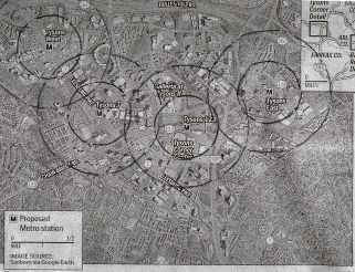
1: WaPo Air photo of the Centre
of Tysons Corner showing the four METRO stations
with .25 and .50 radii around each station
superimposed.
Graphic
2: Underground
rail scenario
Graphic
3: Above ground
scenario
Graphic
4: Pyramid Strategy with Public Way
Rights scenario. 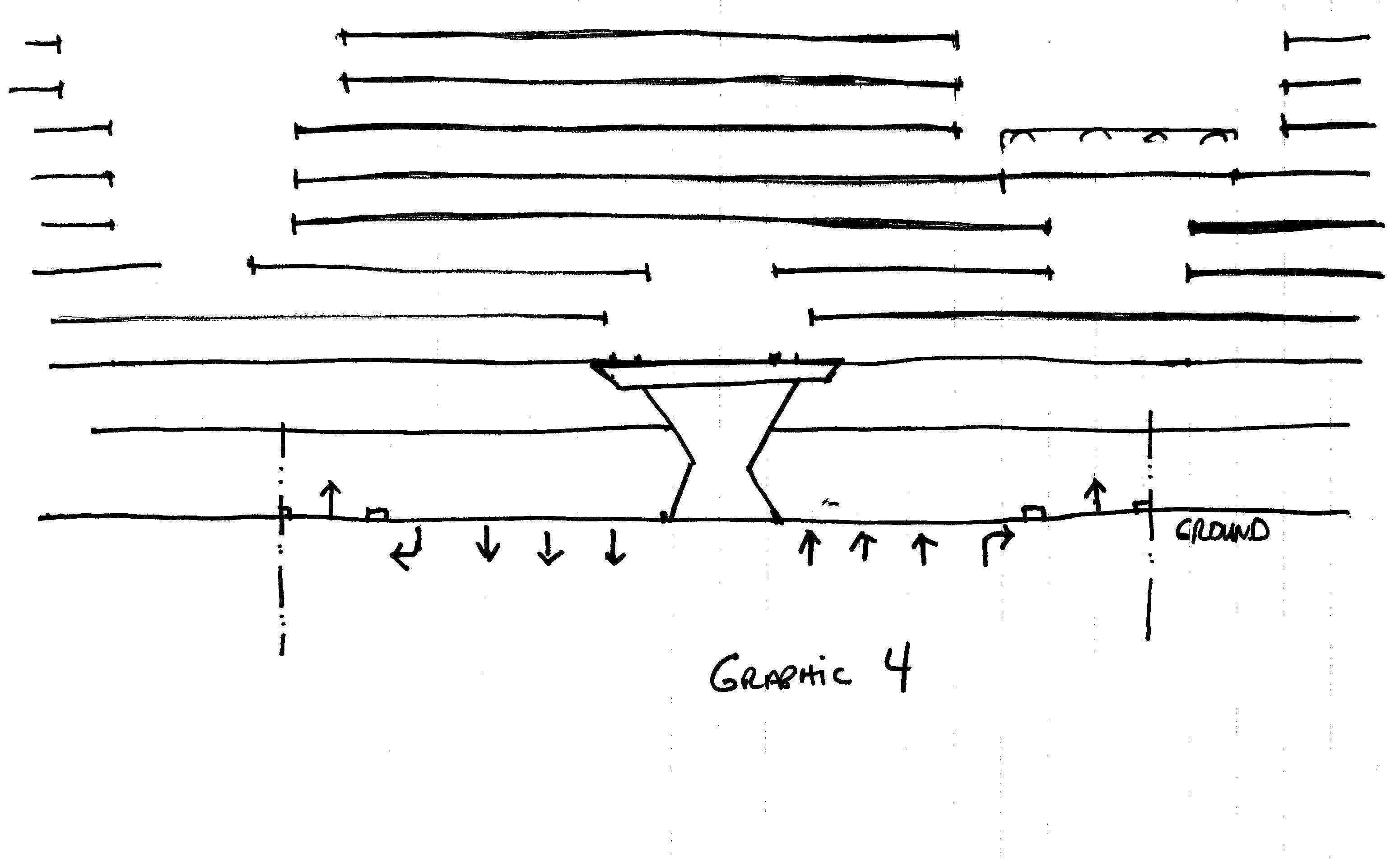
Graphic
5: Richard L. Thornton rendering
|